Aim
In this module you will gain a detailed understanding of the advantages and challenges of Earth observation using Light Detection and Ranging (LiDAR) systems. Compared to other types of remote sensing data, the data from active Light Detection and Ranging (LiDAR) systems is of particular importance for local studies, where the 3D component (height) of objects is of relevance. Commonly LiDAR data is applied it in the field of digital terrain modelling, in forestry – e.g. for canopy height assessment, or urban structure applications. LiDAR embraces a range of active remote sensing systems mounted on different platforms, which provide valuable information for characterization of horizontal and vertical structure of the earth surface by measuring the travel time of laser pulses in visible and near-infrared spectral domains. The quality of scanning depends on the nature of the LIDAR system (discrete-return or full waveform) as well as on a set of other terrain- and data-driven factors. This course provides you with an overview on the theory and applications of LiDAR data, with a particular focus on airborne laser scanning. Following the initial theoretical sections on the principles and basic characteristics of LiDAR data, diverse practical steps and exercises will be implemented to provide real-world examples to illustrate how the LiDAR point clouds can be applied to extract information on terrain, surface and vegetation. These information will be further employed to model vegetation structural attributes on multiple spatial scales ranging from single trees to landscape levels.
Content
Block 1: Introduction to LiDAR (how does laser scanning work?)
- Reminder on general remote sensing issues: difference between active and passive sensing
- History of LiDAR measurements
- Basics of LiDAR data measurements (platforms, sensors)
- Airborne vs. spaceborne LiDAR: history, applications and data access
- Measurement of travel time of laser light (pulsed time of flight)
- On the concept of “structure”: why a third dimension is crucial?
Block 2: Principles of LiDAR measurements
- Platform navigation, orientation and positioning
- Difference between types of data acquisitions: discrete return and echo waveform
- The recorded parameters: elevation, height, signal intensity and co.
- The concept of „single-pulse“ vs. „multiple-pulse“
- How are the incoming returns recorded? first come- first served!
- Terrestrial LiDAR measurement: one position, rotating scanner
- Data formats and big data-management: each byte matters!
Block 3: Elevation models:
- General thoughts: why are the elevation models essential?
- Digital terrain models
- Digital surface models
- Normalized DSM (Canopy height models)
- Application fields: Forest, landscape and habitat representations
- Magnified focus on Forest (basic and derived parameters): Diameter at breast height, height, tree type proportions, tree type mapping, crown closure, stem count, growing stock und aboveground biomass
- Single tree measurements
- Urban: City models, roof top and building footprints
Block 4: Exercises in Open-Source domain of LiDAR data processing (Fusion/LDV, LASTools, R)
- Exercises on point cloud processing
- Import, export, visualizations and rendering
- Sample measurements, single tree measurements and associated tasks
- Elevation models
- Data trimming, cropping, smoothing and generalizing
- Catalog and descriptive communication
- Extraction of metrics for modeling purposes
- Thoughts on metrics
- Intensity: yes or no?
- Multi-scale metric extraction
- Multi-source metric extraction
- Class works and workshops (CIP-Pool/Homework)
- Literature review, discussion groups and public presentations
Coding
Coding examples and individual work will be covered
Software
Various software programs will be used, but mainly OpenSource software such as R.
Techniques
Different techniques will be introduced and practically applied.
Content
The content of scientific with regard to the audience will be discussed.
General Course News and Updates

Master Thesis Defense: “Assessing Air Pollution in Urban Environments: A Comprehensive Analysis Using Earth Observation and In Situ Measurements” on Friday, March 08 at 13:00
On Friday, March 08, at 13:00, Andreas Bury will present his master thesis on "Assessing Air Pollution in Urban Environments: A Comprehensive Analysis Using Earth Observation and In Situ Measurements" in seminar room 3, John-Skilton-Str. 4a. From the...

High alpine and snow training
In collaboration with the German Alpine Club (DAV), Laura, one of our EAGLE students and Clara, a student assistant at our institute, recently participated in avalanche rescue training aimed at equipping individuals with essential skills and knowledge to respond...

semester wrap-up by our latest EAGLE generation
Our latest generation of EAGLEs just wrote a nice blog post summarizing their first months within the EAGLE program, outlining how they bonded and formed a group plus how they experienced their first earth observation courses within our international M.Sc. program:...

Internship Report by Sharmin Shara Mim on February 27 at 12:30 p.m.
On Tuesday, February 27 at 12:30 Sharmin Shara Mim will present her internship report on global aquaculture production (seminar room 3, John-Skilton-Str. 4a). From the abstract: Global aquaculture production has been increasing recently. Asia has a positive...

Internship Presentation on February 27 at 12:00 p.m.
On Tuesday, February 27 at 12:00 Luisa Pflumm will present her innolab report on developing a processing pipeline to produce photogrammetry products in UAS acquired imagery using Agisoft Metashape software (seminar room 3, John-Skilton-Str. 4a). The work of the...

International Day of Women and Girls in Science
We would like to celebrate the International Day of Women and Girls in Science with you! It is celebrated annually on February 11th. This day aims to promote full and equal access to science for women and girls, as well as to recognize the achievements of women in...

GRASS GIS introduced in our EAGLE MSc
The very powerful and versatile spatial analysis program, GRASS, is introduced today within our EAGLE spatial data software course. GRASS provides a wide variety of functions, but just a few possibilities such as VI calculation, time-series or Python programming in...

Introduction to Whitebox software
The Whitebox geospatial software offers a wide range of functionality which are partly also not available in other packages, such as hydrological analysis or Lidar processing. Our earth observation EAGLE students are learning diverse geospatial software packages in...

Internship Networking event
Our EAGLEs have to conduct two internship and like to do them in quite diverse fields. Their research interests range from dry ecosystems to mountains, from conservation to agriculture, from the Arctic to Africa and from Earth Observation companies to large research...
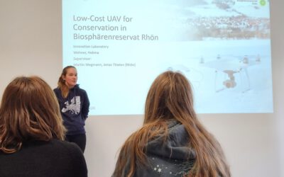
UAS application in a biosphere reserve
Our EAGLE Helena Wehner presented her work in the Rhoen biosphere reserve where she tested the potential of low cost consumer drones for conservation. She aimed at mapping animal tracks using photogrammetry approaches in snowy landscapes. The structure through...