this Friday, 22nd of April, at 9am we will have one inno lab and one M.Sc. defense, both by Jakob Wachter.
inno lab: “Assessment of climate-induced drought impact on crop types in bavaria” (Tobias Ullmann)
M.Sc. defense: “Potential of webcam Imagery as reference data for Earth Observation Snow Cover products in mountainous areas” supervisors: PD Dr. Tobias Ullmann, Dr. Mattia Rossi (EURAC Research), from the abstract:
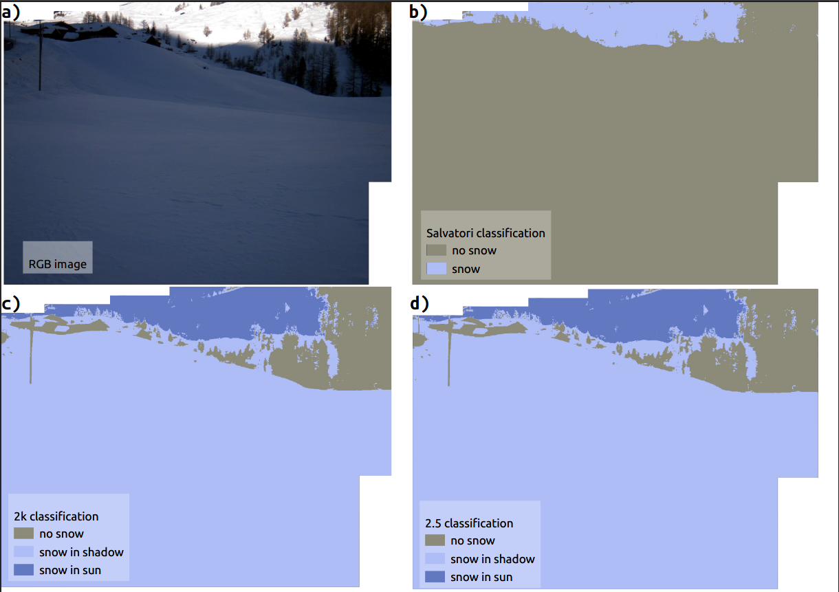
“Snow cover in mountainous areas is an important variable for a wide range of ecological and societal factors. Extensive monitoring of Fractional Snow Cover (FSC) and snow related processes has been performed with active and passive satellite earth observation data sources. However, there are limitations to using satellite data, such as their temporal and spatial resolution or cloud coverage. At the same time reliable in-situ information is a key factor to validate snow cover products. To enhance the temporal and
spatial information on ground, openly accessible webcam data show great potential by continuously providing information in many locations. Additional challenges emerge from the use of this data source such as the different view angle compared to satellites, the location of the station or weather influences near the ground. This thesis presents a novel approach to automatically and effectively derive snow cover from webcam images. We use an RGB image timeseries from two different webcams in the Italian Autonomous Province of South Tyrol covering the years of 2019 and 2020 respectively. First the webcam images are filtered to exclude unfavorable weather conditions. On the filtered timeseries three snow extraction models are compared: (1) state-of-the-art simple thresholding method, (2) K-means unsupervised clustering into bright and shadow areas followed by thresholding for each cluster to account for brightness differences and (3), a hybrid approach choosing the state-of-the-art method (1) in case of homogenous illumination (little shadows) and choosing the clustering method (2) in case of heterogenous illumination (many shadows). This is implemented in order to deal with classification errors due to pronounced illumination differences between shadowed and non-shadowed areas within an image. The detected snow cover information can finally be compared to satellite-derived snow cover products. Regions of Interest (ROIs) have been delineated on the webcam image and manually matched to the corresponding Sentinel-2 pixels to gain a more detailed insight. The validation of the workflow is done through visual inspection and classification into the presented classes of 9-14 example images per webcam. FSC can be automatically detected over the course of one year for each image timestep (Figure 3). The accuracies from the confusion matrix of the model results compared to visual inspection are 0.76 and 0.81 in average for the model (1), 0.86 and 0.74 averagely for the model (2) and 0.98 and 0.81 in average for the model (3). Measurements from Sentinel-2 based snow cover products and the webcam measurements show an R² between 0.0025 and 0.51 at the model (1), between 0.12 and 0.56 for the model (2) and between 0.17 and 0.72 for the model (3). Root Mean Square Error (RMSE) values range between 0.46 and 0.17 for the model (1), between 0.37 and 0.2 at the model (2), and for the model (3) between 0.33 and 0.19. The novel approach allows a more-in-depth analysis of relevant phases in mountain snow dynamics such as the melting in spring or new snow events. The approaches (2) and (3) have shown, with slight differences depending on the webcam, better performances when compared to the current state-of-the-art method, with an increased R² value for most examples.”


