
 The Bavarian Forest and the Bohemian Forest together form the largest contiguous forest area in central Europe, which is of an extraordinary importance for the protection and maintenance of biological diversity. Since 1970, a large area of the forest is protected as a National Park, in which “nature can be nature”. Bark beetle outbreaks control large forest areas, lynx and wolves roam the forest, and carrion beetles consume the remains of dead vertebrates. Therefore, the national park it is one of the few places, where scientist can study natural processes and their impacts.
The national park was also the destination of this winter´s course in Forest Ecology offered by Prof. Dr. Jörg Müller, Professor for Animal Ecology at the University of Würzburg and Deputy Head of the Bavarian Forest National Park. The research of Prof. Dr. Müller links field observations and ecological questions with remote sensing to understand species habitat requirements and assemblages at larger spatial scales. The project work during the course also combined field work and spatial analysis using high resolution LIDAR data.
For the field work, 24 plots in the forest were set up along a gradient of different bark beetle infestation intensities. The projects goal was the assessment of the ecological and monetary value of these different forest areas, which involved the mapping of birds and mammals, the characterization of the plots including the wood-value per plot and the student´s personal aesthetic assessment via questionnaires. Using snow-shoes, the students visited and assessed the plots and experts with experience in ornithology and the identification of animal tracks were helping along the way.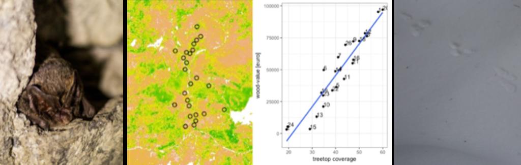
The results indicate a shrinking aesthetic value and a decreased willingness-to-pay for forest areas with higher percentages of dead-wood. Using the LIDAR data, individual trees were recognized and the total wood-value per plot was calculated. The evaluation of this dataset showed that the wood-value per plot was positively correlated with the treetop coverage. Because of a thick snow-cover within the national park, only a few bird species could be mapped and statements on their habitat preference were therefore not possible. However, the abundance of oldcrests (Regulus regulus) and coal tits (Parus ater) was positively correlated with an increasing percentage of coniferous wood in the forest areas. Even though, the students were not able to statistically prove the importance of dead wood as a landscape component, mainly because of the low abundance of winter birds, the pure presence of rare bird species like the three-toed woodpecker (Picoides tridactylus) indicates the high ecological value of the bark-beetle areas in the park.
Beside the interesting project work, the course also offered informative presentations on different animal groups within the national park, the parks management and future challenges. Additionally, the students had the possibility to participate in different excursions, e.g. to identify bats in their winter roost, map owls during night and to visit a red deer carcass.
Thanks to Dr. Martin Wegmann and Prof. Dr. Jörg Müller and his team for enabling the interdisciplinary course, for encouraging the exchange among students and the good time in the Bavarian Forest!
text and photos: Anna-Lena Hendel


