Internship, Innovation Lab and MSc idea presentations

The following students presented their innovation labs, internships and ideas for MSc. thesis:
Ahmed: ‎
Innovation Lab at DLR (team of Ursula Gessner) and Master Thesis Idea:
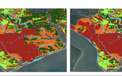
Title: Status of Agricultural Lands in Egypt using Earth Observation
Maninder (at DLR, Demmin):
Internship: To find a best fit model by comparing various Evapotranspiration  models using the weather station data for Toitz station, Germany
Thesis idea: comparing the performace of different crop growth models using synthetic remote sensing data at Demmin, Germany
Pilar:
Thesis idea: Time series analysis of flooding and vegetation patterns in wetlands of Colombian Orinoco Basin

read more news:

High alpine and snow training

High alpine and snow training

In collaboration with the German Alpine Club (DAV), Laura, one of our EAGLE students and Clara, a student assistant at our institute, recently participated in avalanche rescue training aimed at equipping individuals with essential skills and knowledge to respond...

semester wrap-up by our latest EAGLE generation

semester wrap-up by our latest EAGLE generation

Our latest generation of EAGLEs just wrote a nice blog post summarizing their first months within the EAGLE program, outlining how they bonded and formed a group plus how they experienced their first earth observation courses within our international M.Sc. program:...

International Day of Women and Girls in Science

International Day of Women and Girls in Science

We would like to celebrate the International Day of Women and Girls in Science with you! It is celebrated annually on February 11th. This day aims to promote full and equal access to science for women and girls, as well as to recognize the achievements of women in...

GRASS GIS introduced in our EAGLE MSc

GRASS GIS introduced in our EAGLE MSc

The very powerful and versatile spatial analysis program, GRASS, is introduced today within our EAGLE spatial data software course. GRASS provides a wide variety of functions, but just a few possibilities such as VI calculation, time-series or Python programming in...

Introduction to Whitebox software

Introduction to Whitebox software

The Whitebox geospatial software offers a wide range of functionality which are partly also not available in other packages, such as hydrological analysis or Lidar processing. Our earth observation EAGLE students are learning diverse geospatial software packages in...