M.Sc. thesis presentation by Ahmed Saadallah

Ahmed Saadallah will defend his M.Sc. thesis “The Potential of Earth Observation for Monitoring Agricultural Lands in Egypt (1984-2017)” on Wednesday 10th of April at 2pm in the student working room JMW 52.

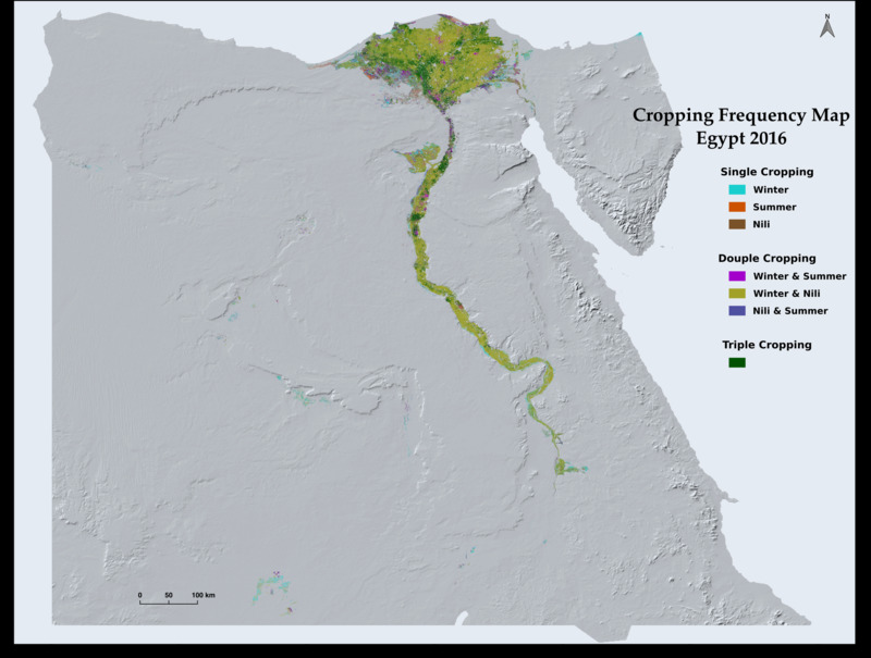
The need for accurate and timely information on the extent and the use-intensity of agricultural lands is growing with the increasing pressure on agricultural systems to increase production, in order to narrow the food gap, while maintaining at the same time the sustainability of the agricultural resources and reducing the negative impacts on the environment. In Egypt, such information is urgently needed for generating effective policies and improving management practices in order to promote the agricultural sector to address current and future challenges. Over the past four decades, it has been proven through the use of Earth Observation (EO) applications that remote sensing data can provide this information accurately, quickly, and at low cost. In this study, the extent and the use-intensity of the agricultural land in Egypt were mapped on an annual basis from 1984 to 2017 using Landsat time series data. Pixel-based supervised classification approach, using Random Forest algorithm, was used to map the extent of cultivated land area annually. Harmonic analysis was used for smoothing and filling the gaps in the time series data of Landsat derived Normalized Difference Vegetation Index (NDVI) in order to identify the Peak of Season (POS) phenological parameter, which was used later to map cropping frequency and estimate Multiple Cropping Intensity (MCI) on annual basis. The overall average classification accuracy was 89%. In addition, the results indicate that the cultivated area in Egypt expanded from 25760 km2 in 1984 to 32539 km2 in 2017, with an overall average increase of 185 km2 per year. Moreover, 86% of the total cultivated area in Egypt on average was multi-cropped. The overall average MCI at the national level for the last 34 years since 1984 is 214%. 

read more news:

High alpine and snow training

High alpine and snow training

In collaboration with the German Alpine Club (DAV), Laura, one of our EAGLE students and Clara, a student assistant at our institute, recently participated in avalanche rescue training aimed at equipping individuals with essential skills and knowledge to respond...

semester wrap-up by our latest EAGLE generation

semester wrap-up by our latest EAGLE generation

Our latest generation of EAGLEs just wrote a nice blog post summarizing their first months within the EAGLE program, outlining how they bonded and formed a group plus how they experienced their first earth observation courses within our international M.Sc. program:...

International Day of Women and Girls in Science

International Day of Women and Girls in Science

We would like to celebrate the International Day of Women and Girls in Science with you! It is celebrated annually on February 11th. This day aims to promote full and equal access to science for women and girls, as well as to recognize the achievements of women in...

GRASS GIS introduced in our EAGLE MSc

GRASS GIS introduced in our EAGLE MSc

The very powerful and versatile spatial analysis program, GRASS, is introduced today within our EAGLE spatial data software course. GRASS provides a wide variety of functions, but just a few possibilities such as VI calculation, time-series or Python programming in...

Introduction to Whitebox software

Introduction to Whitebox software

The Whitebox geospatial software offers a wide range of functionality which are partly also not available in other packages, such as hydrological analysis or Lidar processing. Our earth observation EAGLE students are learning diverse geospatial software packages in...

Internship Networking event

Internship Networking event

Our EAGLEs have to conduct two internship and like to do them in quite diverse fields. Their research interests range from dry ecosystems to mountains, from conservation to agriculture, from the Arctic to Africa and from Earth Observation companies to large research...