MSc defense by Larissa Gorzawski

On Wednesday 5th of October at 2pm Larissa will present her M.Sc. thesis “Deep transfer learning on street-level imagery for classification of seismic building types in Lima, Peru”.

From the abstract: “Comprehensive exposure models for seismic risk assessment require accurate building inventories in the endangered areas. The learning capabilities of Deep Learning (DL) can be combined with street-level imagery to categorize buildings in an automated way. Since the training of a DL model requires large amounts of data, in this thesis, a transfer learning approach will be employed to adapt an already trained model to a new study area and a different image dataset while minimizing the labeling requirements. The used model was trained by Aravena Pelizari, et al. (2021) with Google Street View (GSV) images in Santiago de Chile and will be adapted to the Peruvian capital Lima and to street-level imagery of the open-source platform Mapillary.

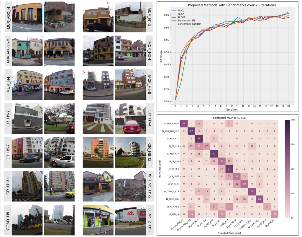
Three data-driven active learning (AL) strategies are designed and implemented with a pre-labeled pool of images: an initial cluster-based sampling with subsequent margin sampling and two additional augmentation strategies exploring the impact of either the most similar source domain images or secondly the addition of high-confidence semi-labeled target domain images.

The methods could achieve an improvement of the F1 accuracy score from 0.31 to 0.67 with a comparatively small amount of labeled images. Though the methods did all per-form similarly, the initial clustering and the semi-labeling of additional target domain images were the most promising approaches. The class accuracies indicate that the class differences between the domains could be learned at least partly quite successfully, while the performance of the data-driven AL methods was presumably limited by the noisiness of the dataset. The methods provided promising first results and could be further improved with diversity-based batch sampling as well as an extension of the semi-supervised learning approach.”

supervisors: Hannes Taubenböck and Christian Geiss

read more news:

High alpine and snow training

High alpine and snow training

In collaboration with the German Alpine Club (DAV), Laura, one of our EAGLE students and Clara, a student assistant at our institute, recently participated in avalanche rescue training aimed at equipping individuals with essential skills and knowledge to respond...

semester wrap-up by our latest EAGLE generation

semester wrap-up by our latest EAGLE generation

Our latest generation of EAGLEs just wrote a nice blog post summarizing their first months within the EAGLE program, outlining how they bonded and formed a group plus how they experienced their first earth observation courses within our international M.Sc. program:...

International Day of Women and Girls in Science

International Day of Women and Girls in Science

We would like to celebrate the International Day of Women and Girls in Science with you! It is celebrated annually on February 11th. This day aims to promote full and equal access to science for women and girls, as well as to recognize the achievements of women in...

GRASS GIS introduced in our EAGLE MSc

GRASS GIS introduced in our EAGLE MSc

The very powerful and versatile spatial analysis program, GRASS, is introduced today within our EAGLE spatial data software course. GRASS provides a wide variety of functions, but just a few possibilities such as VI calculation, time-series or Python programming in...

Introduction to Whitebox software

Introduction to Whitebox software

The Whitebox geospatial software offers a wide range of functionality which are partly also not available in other packages, such as hydrological analysis or Lidar processing. Our earth observation EAGLE students are learning diverse geospatial software packages in...

Internship Networking event

Internship Networking event

Our EAGLEs have to conduct two internship and like to do them in quite diverse fields. Their research interests range from dry ecosystems to mountains, from conservation to agriculture, from the Arctic to Africa and from Earth Observation companies to large research...