Malin Fischer will present her MSc thesis “Remote sensing and machine learning for irrigation mapping in complex landscapes: a case study in Mozambique” on Wednesday, 10th of November at 9 am.
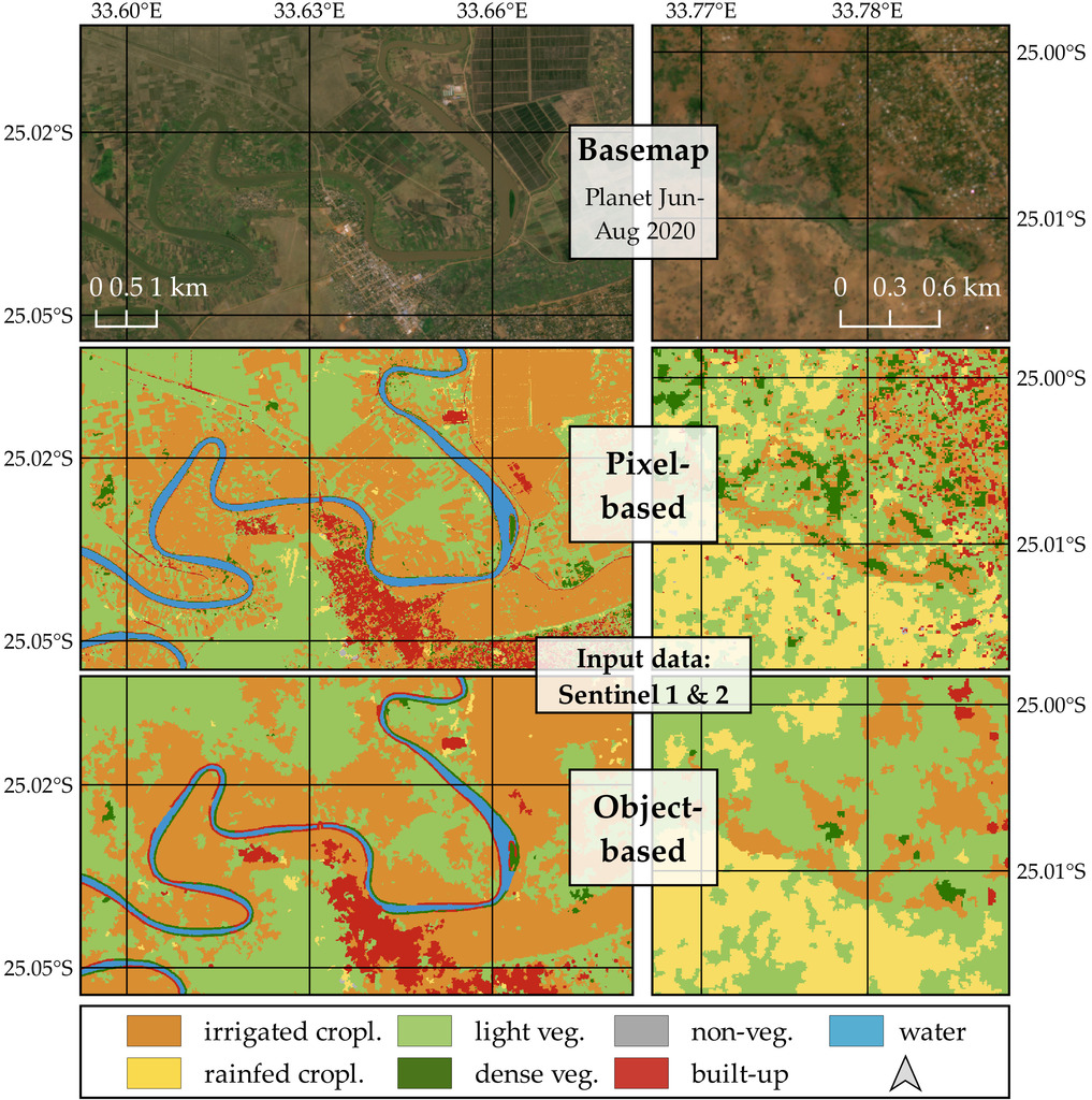
From her abstract: “Analyzing the spatio-temporal distribution of irrigated agriculture is essential for informed decision-making to sustainably manage limited freshwater resources. The increasing availability of satellite data, in combination with Machine Learning techniques, provides new opportunities to map this multi-faceted, dynamic land use class. This study investigates respective methodological challenges, and how a workflow design can be optimized to mitigate them. Therefore, a modular, customizable supervised classification method was developed using a Random Forest classifier, instead of following a rule-based, hardly generalizable approach, as most previous studies did. It allows for modifications of input datasets and feature extraction methods, which were identified as relevant design choices. Several experimental runs were conducted in a complex Mozambican landscape with large-scale as well as smallholder farming and irrigation. Temporally aggregated features of dense dry season time-series were generated. The combined use of radar and optical data proved beneficial, unlike the addition of ancillary topographic and aggregated precipitation data. Single-source optical classification outperformed purely radar-based models. The latter benefits from an object-based feature extraction, contrary to all other runs. Here, a segmentation without object vectorization was a limiting factor. However, sample selection had the strongest impact on classification accuracy, emphasizing the need for larger, more representative reference datasets at higher thematic detail. This would be particularly useful for distinguishing rainfed fields and light vegetation, which proved to be more challenging than identifying irrigation. A partial mitigation of the less-than-ideal reference data was achieved using class-representative sampling and cross-validation aggregations. Combined radar-optical models were transferred to another region with differing landscape characteristics. Identifying previously unrepresented land forms and differing irrigation practices proved difficult. The overall good result still encourages future transferability assessments, and emphasizes the demonstrated potential of Machine Learning-based remote sensing studies to close irrigation data gaps.”
supervisors: Martin Wegmann and Ursula Gessner (DLR) in cooperation with Timon Weitkamp (Wageningen University & Research)


