Aim
In this lecture you will gain a broad overview of the applications of remote sensing. Examples from different disciplines and applied Earth Observation projects will provide your with a comprehensive understanding of if, where and how remote sensing can contribute to qualitative and quantitative assessments of the cryosphere, forest ecosystems, agro-ecosystems, the coastal zone and urban ecosystems; amongst others. We will evaluate the potential of passive and active sensor systems and adress the advantages and shortcomings of existing sensors in the optical / mutlsispectral, thermal and microwave domain.
Content
This lecture provides knowledge on applications of Earth Observation with a focus on remote sensing of the land surface. Which research questions of different disciplines can be answered by the means of Earth Observation? What are the main approaches? The module links up remote sensing measurements to geo- and biophysical parameters required for further geoanalysis. Commonly used methodological approaches for the derivation of the different parameters are presented. Examples include amongst others applications in geography, environmental planning, ecology, biology, oceanology, soil science, geology, atmospheric science, but also e.g. pollution control (monitoring) and natural resource management. In addition, the module outlines selected examples, how remote sensing technology can be transferred to the workplace of professionals also beyond science, e.g. via the use of geoinformation systems.
General Course News and Updates
EAGLE Internship Presentation: Remote sensing for Ecological Applications in the High Arctic
On April 13, 2026, Clara Vydra will present her internship results on " Remote sensing for Ecological Applications in the High Arctic" at 15:30 in seminar room 3, John-Skilton-Str. 4a. From the abstract: This internship focused on supporting Master students in their...
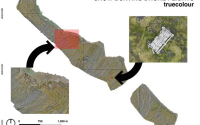
EAGLE MSc Defense: Current Status, Trends, and Future Challenges of the Alpine Cryosphere, Illustrated by an Example from the Hohe Tauern National Park
On April 27, 2026 Clara Vydra will present her Master Thesis on "Current Status, Trends, and Future Challenges of the Alpine Cryosphere, Illustrated by an Example from the Hohe Tauern National Park" at 14:00 in seminar room 3, John-Skilton-Str. 4a. From the abstract:...

🦅 Don’t Miss the EAGLE M.Sc. Application Deadline – May 15
The deadline to apply for the EAGLE M.Sc. “Applied Earth Observation and Geoanalysis of the Living Environment” program is approaching quickly - applications must be submitted before midnight May 15th (CEST) for a winter term start in October. Located at our EORC at...

EAGLE social ski retreat
To recharge their batteries after an intense semester, some EAGLE students went skiing together in the Austrian Alps, taking the opportunity to experience cold-region environments themselves. Beyond the thrill of the slopes, the trip allowed students to observe snow...

EAGLE Internship Presentation: Geomorphological Monitoring at Askja Caldera: Field Observations of Subsurface Instability
On April 28, 2026, Hanna Zoë Schulten will present her internship results on " Geomorphological Monitoring at Askja Caldera: Field Observations of Subsurface Instability" at 12:30 in seminar room 3, John-Skilton-Str. 4a. From the abstract: Volcanic calderas are...

From Data to Impact: Viktoria Veith’s Internship at WWF
Understanding the environmental consequences of conflict is one of the most pressing challenges in contemporary Earth observation. During her internship at WWF, EAGLE MSc student Viktoria Veith has been working at the intersection of remote sensing, policy, and...

EAGLE MSc Defense: Developing a Farmland Habitat Biodiversity Indicator for Bavaria (in line with OECD Guidelines)
On March 31, 2026, Suriya Elango will present his Master Thesis on " Developing a Farmland Habitat Biodiversity Indicator for Bavaria (in line with OECD Guidelines)" at 12:00 in seminar room 3, John-Skilton-Str. 4a. From the abstract: Farmland Biodiversity is...

Successful MSc Defense: Advancing Synthetic High-Resolution Remote Sensing
We are pleased to congratulate Georg Starz on the successful defense of his MSc thesis within the EAGLE programme. His work, titled “Synthetic High-Resolution Remote Sensing Image Generation – A Comparative Study of Model Training, Surface Data Variability and...

EAGLE Innolab Presentation: Very high-resolution UAV-based Weed Segmentation: Data Processing, Modelling, and Exploration of Vision-Language Models for Agriculture
On April 28, 2026, Hanna Schulten will present her Innolab results on "Very high-resolution UAV-based Weed Segmentation: Data Processing, Modelling, and Exploration of Vision-Language Models for Agriculture" at 12:00 in seminar room 3, John-Skilton-Str. 4a. From the...

EAGLE MSc Defense: Assessing the potential of multispectral UAS and PlanetScope imagery for estimating vegetation structure and biodiversity metrics in urban green spaces
On March 27, 2026, Max Merzdorf will present his Master Thesis on " Assessing the potential of multispectral UAS and PlanetScope imagery for estimating vegetation structure and biodiversity metrics in urban green spaces" at 12:30 at the meeting room 01.B03 (first...