Surface model creation from multi-source remote sensing data

Surface_model_creation

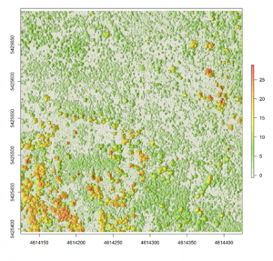
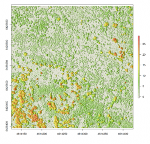
A canopy height model (CHM) overlaid on a hillshade product based on LiDAR point cloud

Nowadays there are plenty of 3D data sources which offer the possibility to model and monitor structural attributes of the landscape via the derivation of terrain, surface and canopy models. The core idea of this research project within an innovation laboratory is to leverage different sources of space- and airborne remote sensing data sources to derive digital surface models (DSMs) from forest stands. This can further provide the necessary database to compare their horizontal/vertical error as well as develop an error budget model by which the propagated error can be characterized. The remote sensing data sources which will be used here represent both landscape- and local scales, with airborne LiDAR and stereo SPOT data representing the landscape and unmanned aerial vehicle (UAV) data representing the local level. The methods include the state of the art as implemented in the available open-source software (FUSION, SAGA) as well as commercial photogrammetric suites (ERDAS Imagine).



read more news:

Summer School of Alpine Research

Summer School of Alpine Research

Last week, Laura, an 8th gen EAGLE Student, participated in the Summer School of Alpine Research, conducted by the University of Innsbruck, in the beautiful location of the Austrian Oetztal in Obergurgl. The focus of the Summer School was on Close Range Sensing...

EAGLE M.Sc. thesis in the Arctic

EAGLE M.Sc. thesis in the Arctic

Our EAGLE student Ronja Seitz is conducting her field work for her Master thesis in the Arctic, on Svalbard. She started collecting her data in June to build up a timeseries with UAS multispectral data to investigate disturbances like rain on snow (ROS) events and...

Our EAGLE Clara is doing her internship in the Arctic

Our EAGLE Clara is doing her internship in the Arctic

Clara, an 8th gen EAGLE, is currently doing her internship in the Arctic. She spends 2 months in Longyearbyen on Svalbard where she works with colleagues from UNIS who are already collaborating with our EORC scientists, namely Dr. Bevanda. Clara works at the Arctic...

Master Defense: Comparing the suitability of remote sensing and wildlife camera time series for deriving phenological metrics of understory vegetation in temperate forests of Upper Franconia, Bavaria

Master Defense: Comparing the suitability of remote sensing and wildlife camera time series for deriving phenological metrics of understory vegetation in temperate forests of Upper Franconia, Bavaria

On September 18, Sarah Schneider will present her master thesis "Comparing the suitability of remote sensing and wildlife camera time series for deriving phenological metrics of understory vegetation in temperate forests of Upper Franconia, Bavaria" at 14:00 in...