M.Sc. defense by Michael Wang

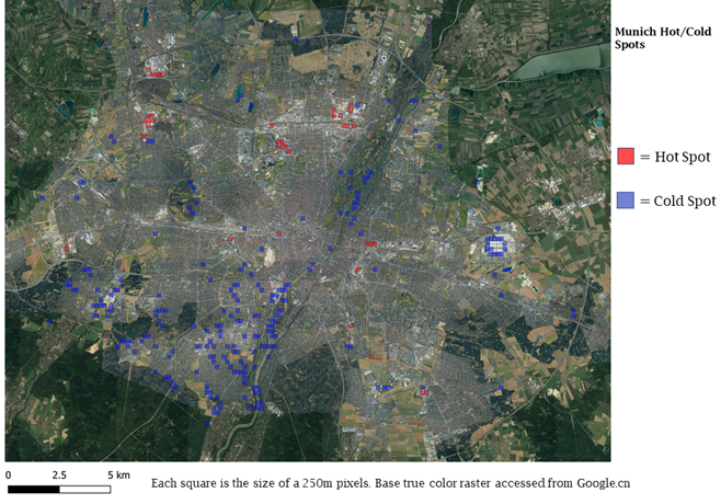
Michael Wang will present his thesis “Comparison of Surface Urban Heat Islands Using the World Settlement Footprint Imperviousness Layer” on Sept. 17th at 10am. From the abstract: “In the growing field of surface urban heat island (SUHI) analysis, impervious surface area (ISA) has been shown to have a strong relationship with land surface temperatures (LST) in cities. Using a globally available high-resolution imperviousness data set, the SUHI intensities (SUHII) of 18 cities of various regions and climates have been derived using three different imperviousness related metrics. The distance to the weighted center of the city provides the most intuitive quantification, however, it is least statically robust, unlike using ISA directly, whose lack of intuitive spatiality must be made up for in other ways. The distance to perviousness offers a compromise between the two, although its synthesis is completely idiosyncratic to its city due to differing urban landscapes. By decomposing the distance intensity into the pervious and impervious components, cities can be categorized into four groups based on combination of cooling and heating effects of each. Further, the ISA intensities can be categorized more broadly as those driven by the urban fabric vs by the industrial zone. Over all the cities, summer dryness is associated with lower or even negative SUHII.”

read more news:

EAGLE summer dialogue

EAGLE summer dialogue

Our annual EAGLE summer dialogue was a great success again even though the weather was quite challenging. The EAGLEs organized a fantastic event with fun activities, great images reviving the last months and years and of course a BBQ, drinks and an outstanding...

new publication by our EAGLE student Clara Vydra

new publication by our EAGLE student Clara Vydra

Our EAGLE student Clara just published an article about snow cover variability in Central Asia - great to see our young EAGLE MSc students being on a good track for their scientific career. from the abstract: "Climate change is affecting the snow cover conditions on a...

UAS team – meme

UAS team – meme

The UAS (UAV or drone) team was quite busy the last months to collect data in Europe, Africa or Arctic and the group spend plenty of hours traveling and collecting Lidar, multispectral, thermal or hyperspectral data in various ecosystems. Of course in many cases faced...

scientific graphics course

scientific graphics course

Beside the various remote sensing courses such as radar, cloud computing, terrain analysis, urban analysis etc. we do also offer courses on softskills such as scientific writing, presentations as well scientific graphics and maps. Within our scientific graphics course...

EAGLE students introduce locust spatio-temporal modeling

EAGLE students introduce locust spatio-temporal modeling

Our EAGLE students Leonie, Sonja and Clara presented methods to model the spatial and temporal distribution of locust in France using statistical modelling approaches within R and the flexSDM package. The elaborated for two hours how the complex data preparation,...