M.Sc. defense by Nina Gnann

Nina Gnann will present her M.Sc. thesis “Identification of anthropogenic debris assisted by unmanned aerial vehicles and deep learning” on September 8th 12pm.

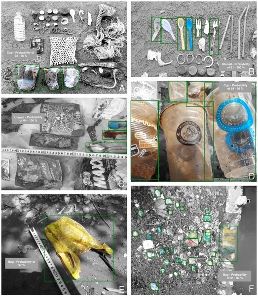
From the abstract: Due to anthropogenic actions, plastic and other debris are distributed in the environment widely. In Cambodia, a country with a weak waste management system, this is particularly evident, when looking at canals, rivers and beaches. In order to generate information about lot sizes of different plastic categories within these environments, a deep learning method is applied and tested on high and low altitude imagery. The data was acquired in October 2019. As applied method, the Mask R-CNN framework was chosen, because of its high accuracy of detection, classification and instance segmentation. Results show that the task of counting lot sizes of different debris items in various complex pictures is feasible. At present time, it can be concluded that objects closer to the observer are detected with higher probability, as objects further away. Though, the potential of improvement by optimizing hyper-parameters, or increasing the number of object masks is given. The existing approach is evaluated with support of a simple hold-out validation. An averaged TPR of 36,6 % for drone and smartphone imagery, and 71,5 % for smartphone images only was yielded. The findings of the confusion matrices are attached. Moreover, the advantages and disadvantages of the methodology are discussed.

read more news:

EAGLE summer dialogue

EAGLE summer dialogue

Our annual EAGLE summer dialogue was a great success again even though the weather was quite challenging. The EAGLEs organized a fantastic event with fun activities, great images reviving the last months and years and of course a BBQ, drinks and an outstanding...

new publication by our EAGLE student Clara Vydra

new publication by our EAGLE student Clara Vydra

Our EAGLE student Clara just published an article about snow cover variability in Central Asia - great to see our young EAGLE MSc students being on a good track for their scientific career. from the abstract: "Climate change is affecting the snow cover conditions on a...

UAS team – meme

UAS team – meme

The UAS (UAV or drone) team was quite busy the last months to collect data in Europe, Africa or Arctic and the group spend plenty of hours traveling and collecting Lidar, multispectral, thermal or hyperspectral data in various ecosystems. Of course in many cases faced...

scientific graphics course

scientific graphics course

Beside the various remote sensing courses such as radar, cloud computing, terrain analysis, urban analysis etc. we do also offer courses on softskills such as scientific writing, presentations as well scientific graphics and maps. Within our scientific graphics course...

EAGLE students introduce locust spatio-temporal modeling

EAGLE students introduce locust spatio-temporal modeling

Our EAGLE students Leonie, Sonja and Clara presented methods to model the spatial and temporal distribution of locust in France using statistical modelling approaches within R and the flexSDM package. The elaborated for two hours how the complex data preparation,...