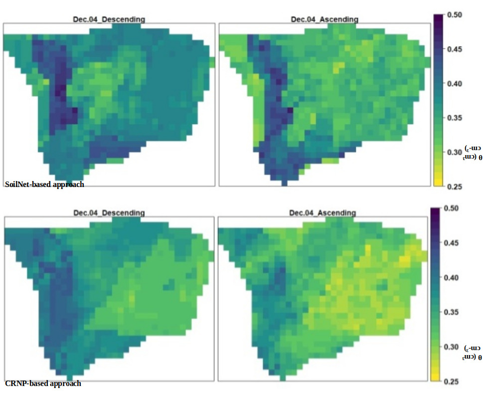
Aida Taghavi will present her M.Sc. thesis “Potentials of Cosmic-Ray Neutron Probes for Assessing and Mapping SAR-based Soil Moisture in a Mediterranean agro-forestry ecosystem” on Dec. 15th at 1pm. From her abstract: “Accurate near-surface soil moisture (~ 5cm, SM5cm) estimation at high temporal and spatial resolutions is one of the most critical challenges in agricultural management and hydrological studies. In recent years, the availability of consistent time series of Synthetic Aperture Radar (SAR) measurements retrieved from Sentinel-1 (S1) provides the opportunity to obtain SM at regular time steps in a wide variety of land surface conditions. The present study aims to estimate and map SM5cm in a small-scale agroforestry experimental site (~ 30 ha) in Southern Italy from November 2018 until March 2019 at high spatial-temporal resolution (17 m × 17 m, 6 days temporal interval). To achieve this study’s aim, the random forest (RF) regression analysis is used by incorporating different input data. The input data includes S1 SAR-based, continuous soil moisture (SM) data at various depths from a cosmic-ray neutron probe (CRNP), distributed in-situ SM data at a depth of 15 cm (SM15cm) and 30 cm (SM30cm) from a wireless sensor network (SoilNet), topographic attributes derived from a Digital Elevation Model (DEM), and SM5cm simulated in Hydrus-1D. Two approaches with different input data combinations are tested. In the first approach, the simplified neutron transport model COsmic-ray Soil Moisture Interaction Code (COSMIC) (SHUTTLEWORTH ET AL., 2013) is implemented in Hydrus-1D (BRUNETTI ET AL., 2019) to provide SM5cm simulations comparable to S1 sensing depth. The RF relies on S1 SAR data, DEM-based attributes, and a single time series of SM5cm simulated in Hydrus-1D, calibrated through inverse modeling at field-scale over the CRNP measurement footprint. The field-scale SM5cm is downscaled to obtain sparse point-scale supporting SM5cm over the same twenty positions using the physical-empirical Equilibrium Moisture from Topography (EMT) model. The second approach is based on S1 SAR parameters, DEM-based features, and twenty time-series SM5cm derived from the inverse modeling of SoilNet data with Hydrus-1D. Validation of the derived SM5cm estimations is accomplished using in-situ SM5cm data from survey campaigns conducted during the S1 satellite overpasses over the experimental area. For decreasing computational effort, the most important S1 SAR and DEM variables are identified through dimension reduction analysis, i.e., variable importance. The CRNP-based approach performed similarly to the one based on SoilNet data. This study highlights the enormous potential for modeling reliable SM5cm maps by integrating S1 SAR-based measurements, topographic information, and CRNP data that has the advantage of being non-invasive and easy to maintain.” supervised by Dr. Sarah Schoenbrodt-Stitt


