Lecturer
Julia Rieder
ECTS
5 ECTS
Aim
The course provides a practical introduction to LiDAR technology and point cloud analysis. Students gain hands-on experience with LiDAR data, from acquisition principles to processing and interpretation, and learn how LiDAR supports applications such as terrain modelling, forestry, and others. The course emphasizes critical understanding of data quality, limitations, and real-world use cases
Content
This course provides an overview of the scientific field surrounding LiDAR as a key technology for three-dimensional Earth observation. The course covers the fundamentals of LiDAR remote sensing, point cloud data structures, and processing methodologies across platforms ranging from spaceborne and airborne systems to terrestrial and mobile laser scanning. Furthermore, the course highlights current developments and emerging analytical possibilities enabled by advanced point cloud analysis and discusses future potential as LiDAR technologies and methodologies continue to evolve and converge with related disciplines.
Coding
Software
Techniques
Content
General Course News and Updates

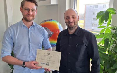
DGPF award for our EAGLE MSc Luisa Wagner
We are very happy to congratulate our former EAGLE student Luisa Wagner for the 2nd prize of the Karl‐Kraus‐Nachwuchsförderpreis 2024. Luisa received this award for her M.Sc. thesis which she handed in early last year on "Analysis of ice shelf front dynamics in Pine...

Master Thesis Defense: “Modelling the Spatio-Temporal Suitability of Urban Environments for Aedes Aegypti Mosquitoes based on their Bio-Ecological Characteristics in Rio de Janeiro “
On Friday, March 22, at 12:00 Rutendo Mukaratirwa will present her master thesis on " Modelling the Spatio-Temporal Suitability of Urban Environments for Aedes Aegypti Mosquitoes based on their Bio-Ecological Characteristics in Rio de Janeiro " in seminar room 3,...
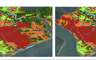
Master Thesis Defense: “Development of Caribbean Seagrass Ecosystem Accounts fusing Earth Observation with Biophysical Modeling of Coastal Carbon” on Tuesday, March 19, 2024
On Tuesday, March 18, at 15:00 Andrea Cárdenas Reyes will present her master thesis on "Development of Caribbean Seagrass Ecosystem Accounts fusing Earth Observation with Biophysical Modeling of Coastal Carbon" in seminar room 3, John-Skilton-Str. 4a. ...
Andreas Bury successfully defended his MSc thesis
Andreas Bury successfully defended his MSc thesis "Assessing Air Pollution in Urban Environments: A Comprehensive Analysis Using Earth Observation and In Situ Measurements" at the EAGLE colloquium on the 8th of March 2024. His research offers an approach to...
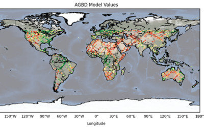
Master Thesis Defense: “CNN-based Global Aboveground Biomass Estimation using Sentinel-2 and GEDI” on Tuesday, March 12, 2024
On Tuesday, March 12, at 12:00 Ka Hei Chow will present her master thesis on " CNN-based Global Aboveground Biomass Estimation using Sentinel-2 and GEDI" in seminar room 3, John-Skilton-Str. 4a. Abstract: Accurate global estimation of aboveground biomass...
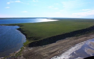
Master Thesis Defense: “Assessing the Mangrove Ecosystem in Eastern Obolo, Niger Delta” on Monday, March 18 at 11:30
On Monday, March 18, at 11:30 Hyeonmin Kang will present her master thesis on "Assessing the Mangrove Ecosystem in Eastern Obolo, Niger Delta" in seminar room 3, John-Skilton-Str. 4a. From the abstract: This study focuses on assessing the mangrove ecosystem in Eastern...

Master Thesis Defense: “Assessing Air Pollution in Urban Environments: A Comprehensive Analysis Using Earth Observation and In Situ Measurements” on Friday, March 08 at 13:00
On Friday, March 08, at 13:00, Andreas Bury will present his master thesis on "Assessing Air Pollution in Urban Environments: A Comprehensive Analysis Using Earth Observation and In Situ Measurements" in seminar room 3, John-Skilton-Str. 4a. From the...

High alpine and snow training
In collaboration with the German Alpine Club (DAV), Laura, one of our EAGLE students and Clara, a student assistant at our institute, recently participated in avalanche rescue training aimed at equipping individuals with essential skills and knowledge to respond...

semester wrap-up by our latest EAGLE generation
Our latest generation of EAGLEs just wrote a nice blog post summarizing their first months within the EAGLE program, outlining how they bonded and formed a group plus how they experienced their first earth observation courses within our international M.Sc. program:...

Internship Report by Sharmin Shara Mim on February 27 at 12:30 p.m.
On Tuesday, February 27 at 12:30 Sharmin Shara Mim will present her internship report on global aquaculture production (seminar room 3, John-Skilton-Str. 4a). From the abstract: Global aquaculture production has been increasing recently. Asia has a positive...