Aim
Aim of this course is to provide you with an overview on geographic processes of urbanization, the related demographic and structural changes of cities, and data analyses methods using remote sensing data for applications in urban geography.
Content
Humankind is within its largest migration ever: from rural areas into cities. The drivers of this global process of urbanization from demographic to economic and the related structural changes cities are facing will be discussed in this course. Remote sensing is one crucial data source in this dynamic transformation and its products are highly relevant for urban planning, as well as environmental management. Within this course different approaches and techniques are covered focusing on deriving relevant information about urbanized areas on different levels of detail. Uni-temporal-, multi-temporal-, and time series based image classification, segmentation, the analyses of point patterns, GIS analyses to assess spatial context and dependencies, as well as analyses in the 3D domain will be addressed in this course. This will be done providing and discussing example applications from different regions globally (e.g. urban sprawl analysis of megacities, the development of new dimensions of urban landscapes such as mega-regions, the rearrangement of business districts within the urban landscape, etc.). You will learn what capabilities Earth observation data, methods and products have for urban research and applications and how to design remote sensing based urban analysis, how to avoid caveats, troubleshoot errors and interpret the results.
General Course News and Updates
EAGLE MSc Defense: “Assessing the potential of thermal UAS for spatio-temporal Arctic snow monitoring – A pilot study in Bjørndalen, Svalbard”
On February 24, 2026, Lena Jäger will present her Master Thesis on "Assessing the potential of thermal UAS for spatio-temporal Arctic snow monitoring - A pilot study in Bjørndalen, Svalbard" at 12:00 in seminar room 3, John-Skilton-Str. 4a. From the abstract: The...
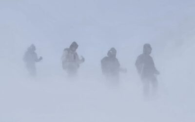
Learning Earth Observation Data Acquisition in Real-World Conditions
As part of our course on Earth Observation data acquisition, EAGLE students experience first-hand that even the best planning is ultimately shaped by the weather. While flight plans, measurement strategies, and schedules can be carefully prepared in advance, field...
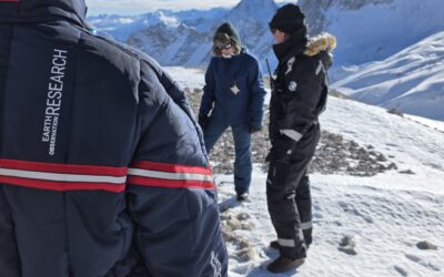
Snow Research at Schneefernerhaus, Zugspitze
Recently, our team carried out another successful field campaign at the Schneefernerhaus research station on the Zugspitze in the Alps. Together with our EAGLE students, we collected UAS-based environmental data alongside detailed in-situ measurements of snow...
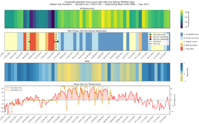
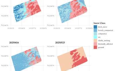
EAGLE MSc Defense: “Detecting Snow Phases and Runoff Using Sentinel-1 SAR and Multispectral–Optical Data”
On December 09, 2025, Daria Ushakova will present her Master Thesis on " Detecting Snow Phases and Runoff Using Sentinel-1 SAR and Multispectral–Optical Data " at 13:00 in seminar room 3, John-Skilton-Str. 4a. From the abstract: Snow is a crucial component of the...
EAGLE Internship Presentation “Detecting Wildfires in Brandenburg, Germany”
On November 18, 2025, Angie Torres will present her internship at " Detecting Wildfires in Brandenburg, Germany" at 12:00 in seminar room 3, John-Skilton-Str. 4a. From the abstract: Wildfires have become an increasing concern in Germany, particularly in the region of...
EAGLE MSc Defense “Modeling Urban Heat Exposure and Vulnerability Integrating Citizen Science and VHR Remote Sensing”
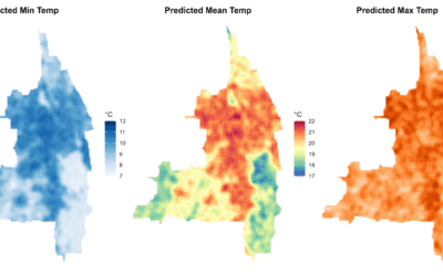
On October 22, 2025, Ariana Sofía Argüello Cordero will present her Master Thesis on " Modeling Urban Heat Exposure and Vulnerability Integrating Citizen Science and VHR Remote Sensing" at 10:15 at the EORC Meeting Room (1st floor), John-Skilton-Str. 4a From the...
EAGLE Internship Presentation “Gobabeb Namib Research Institute”
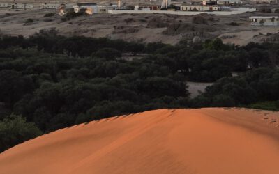
On October 21, 2025, Farimah Abdolzadeh will present her internship at " Gobabeb Namib Research Institute " at 12:30 in seminar room 3, John-Skilton-Str. 4a. Farimah has just completed her internship at the Gobabeb Namib Research Institute, located in the heart of...
EAGLE Innolab Presentation “Modeling Tree-Level Beech Leaf Loss in Bavaria Under Climate Stress with Multimodal Deep Learning Architectures”
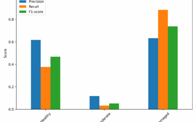
On October 21, 2025, Henning Riecken will present his Innolab results on " Modeling Tree-Level Beech Leaf Loss in Bavaria Under Climate Stress with Multimodal Deep Learning Architectures " at 12:00 in seminar room 3, John-Skilton-Str. 4a. From the abstract: European...

Welcome to our new EAGLEs – Embarking on an Earth Observation Journey
As the autumn term begins and the leaves turn golden across Europe, we are pleased to welcome a fresh cohort of EAGLEs—our new MSc students in Earth Observation and Geoinformatics. This year’s group brings together curious minds from diverse academic and cultural...
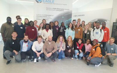
New EAGLEs take off into the Winter Term 2025/26
As in previous years, the next generation of EAGLE Master's students from around the world gathered at the Earth Observation Research Center (EORC) on the first day of the winter term to begin their studies at the University of Würzburg. Prof. Dr. Tobias Ullmann...