
Mandatory courses (40 ECTS)
mandatory courses in the 1st and 2nd semester cover basic skills for Earth Observation research
Theoretical basics (15 ECTS)
No Results Found
The page you requested could not be found. Try refining your search, or use the navigation above to locate the post.
Methodological Basics (15 ECTS)
No Results Found
The page you requested could not be found. Try refining your search, or use the navigation above to locate the post.
Practical Applications (10 ECTS)
No Results Found
The page you requested could not be found. Try refining your search, or use the navigation above to locate the post.
Compulsory elective area (50 ECTS)
Overarching Methods and Applications in Earth Observation (10-20 ECTS)
the application courses offer a more in-depth study of various Earth Observation applications:
No Results Found
The page you requested could not be found. Try refining your search, or use the navigation above to locate the post.
Fokus Area Environment or Urban Methods and Applications
these courses aim to deepen you knowledge in the Urban or Environment field of Earth Observation:
No Results Found
The page you requested could not be found. Try refining your search, or use the navigation above to locate the post.
Soft Skills (5-15 ECTS)
courses to learn about scientific writing, presentation, project management and other topics relevant for Earth Observation research:
No Results Found
The page you requested could not be found. Try refining your search, or use the navigation above to locate the post.

Exemplary course syllabus for different focus areas
some suggestions for optional courses for different focus areas are listed on the EAGLE specialization page

Recent News
Learn about EAGLE updates and general news
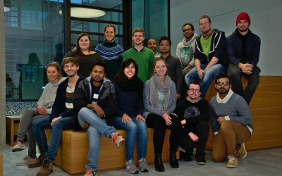
The 2016 EAGLEs
Our EAGLEs in 2016: Johannes Löw. Sarah Nolting, Marcus Groll, Bharath Selvaraj, Sebastian Roersch, Ahmed Saadallah, Marina Reiter, Pilar Endara Pinillos, Sazu Shahjahan, Ahmed Fowad, Jakob Schwalb-Willmann, Julia Sauerbrey, Louis Freytag, Karten Wiertz, Kamrul Islam...

EAGLE 2016 welcome
On Monday 17th of October we welcomed our new EAGLE students. The EAGLEs in 2016 are from Afghanistan, Bangladesh, Columbia, Egypt, India, Iran, Pakistan, Sweden and Germany. After the official welcome by all lecturer and the study program coordinator Christopher Conrad and the head of the remote sensing department and director of the DLR-DFD, Stefan Dech,
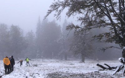
field course on remote sensing in the Bavarian Forest NP
The course on remote sensing for biodiversity analysis covered 10 days of field work, R coding, testing field methods such as UAVs and lots of hiking in the National Park Bavarian Forest. This year we had sunny and rainy weather and on the peaks also snow which made...