
Mandatory courses (40 ECTS)
mandatory courses in the 1st and 2nd semester cover basic skills for Earth Observation research
Theoretical basics (15 ECTS)
No Results Found
The page you requested could not be found. Try refining your search, or use the navigation above to locate the post.
Methodological Basics (15 ECTS)
No Results Found
The page you requested could not be found. Try refining your search, or use the navigation above to locate the post.
Practical Applications (10 ECTS)
No Results Found
The page you requested could not be found. Try refining your search, or use the navigation above to locate the post.
Compulsory elective area (50 ECTS)
Overarching Methods and Applications in Earth Observation (10-20 ECTS)
the application courses offer a more in-depth study of various Earth Observation applications:
No Results Found
The page you requested could not be found. Try refining your search, or use the navigation above to locate the post.
Fokus Area Environment or Urban Methods and Applications
these courses aim to deepen you knowledge in the Urban or Environment field of Earth Observation:
No Results Found
The page you requested could not be found. Try refining your search, or use the navigation above to locate the post.
Soft Skills (5-15 ECTS)
courses to learn about scientific writing, presentation, project management and other topics relevant for Earth Observation research:
No Results Found
The page you requested could not be found. Try refining your search, or use the navigation above to locate the post.

Exemplary course syllabus for different focus areas
some suggestions for optional courses for different focus areas are listed on the EAGLE specialization page

Recent News
Learn about EAGLE updates and general news
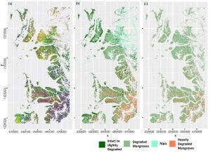
MSc handed in on impact of remote sensing for biodiversity monitoring
Anna Stephanie handed in her MSc thesis on “Impact of remote sensing characteristics for biodiversity monitoring”. Very impressive study on multi-scale, multi-model and multi-variable analysis of mangroves in Myanmar. She was supervised by Martin Wegmann. While...
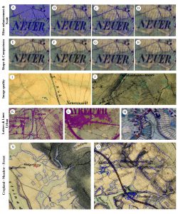
MSc handed in on object-oriented classification of historical maps for ecosystem services
Yrneh Ulloa handed in her MSc “Land change in the Main catchment with an Object Based approach using eCognition” within GCE which dealt with classifying landcover in historical maps (1810+) automatically using object oriented approaches. She was supervised by Martin...
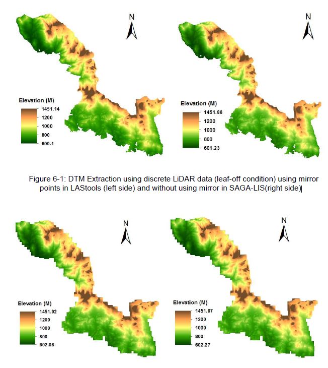
MSc: Analysis of Airborne LiDAR Data for Deriving Terrain and Surface Models
The M.Sc thesis by Raja Ram Aryal has been handed in (supervision of Dr. Hooman Latifi and Prof. Michael Hahn). The thesis focused on a comparative study on the variations of an adaptive TIN ground filtering algorithm to extract DTM from discrete LiDAR point cloud...