
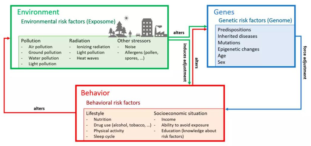
Congratulations to our EAGLE student Patrick Sogno who published together with Prof. Claudia Kuenzer a review article on “Earth Observation Data Supporting Non-Communicable Disease Research: A Review”. From the abstract: “A disease is non-communicable when it is not transferred from one person to another. Typical examples include all types of cancer, diabetes, stroke, or allergies, as well as mental diseases. Non-communicable diseases have at least two things in common—environmental impact and chronicity. These diseases are often associated with reduced quality of life, a higher rate of premature deaths, and negative impacts on a countries’ economy due to healthcare costs and missing work force. Additionally, they affect the individual’s immune system, which increases susceptibility toward communicable diseases, such as the flu or other viral and bacterial infections. Thus, mitigating the effects of non-communicable diseases is one of the most pressing issues of modern medicine, healthcare, and governments in general. Apart from the predisposition toward such diseases (the genome), their occurrence is associated with environmental parameters that people are exposed to (the exposome). Exposure to stressors such as bad air or water quality, noise, extreme heat, or an overall unnatural surrounding all impact the susceptibility to non-communicable diseases. In the identification of such environmental parameters, geoinformation products derived from Earth Observation data acquired by satellites play an increasingly important role. In this paper, we present a review on the joint use of Earth Observation data and public health data for research on non-communicable diseases. We analyzed 146 articles from peer-reviewed journals (Impact Factor ≥ 2) from all over the world that included Earth Observation data and public health data for their assessments. Our results show that this field of synergistic geohealth analyses is still relatively young, with most studies published within the last five years and within national boundaries. While the contribution of Earth Observation, and especially remote sensing-derived geoinformation products on land surface dynamics is on the rise, there is still a huge potential for transdisciplinary integration into studies. We see the necessity for future research and advocate for the increased incorporation of thematically profound remote sensing products with high spatial and temporal resolution into the mapping of exposomes and thus the vulnerability and resilience assessment of a population regarding non-communicable diseases.” and read more here:


