About
Dr. Martin Bachmann is research scientist with the Applied Spectroscopy Group at the German Remote Sensing Data Center, German Aerospace Center (DLR), Wessling, Germany. He has over 10 years of experience in the fields of hyperspectral data analysis and data pre-processing. For 8 years he was in charge of the data pre-processing chain of DLR’s Optical Airborne Remote Sensing and Calibration Facility (OpAiRS). He leads the work package on “Data Quality Control’ within the EnMAP ground segment, and is involved in the FP7 EUFAR Joint Research Activity on Data Quality Control for airborne hyperspectral and LiDAR pre-processing. In addition, he is also involved in the pre-processing of NOAA AVHRR time series within DLR’s TIMELINE project, and was involved within ESA CCI “fire” within the same field of activity. His research interests also include the development and application of spectral unmixing approaches, and algorithm developments towards the derivation of soil parameters using field, laboratory and airborne spectroscopy. His teaching and training experience is focusing on field and imaging spectroscopy, and includes courses at the Universities of Wuerzburg and Jena, within FP6 Marie Curie Project “Hyper-I-Net”, for Carl-Cranz-Gesellschaftand within DLR capacity building activities.
Courses

Recent News

Internship Report by Sharmin Shara Mim on February 27 at 12:30 p.m.
On Tuesday, February 27 at 12:30 Sharmin Shara Mim will present her internship report on global aquaculture production (seminar room 3, John-Skilton-Str. 4a). From the abstract: Global aquaculture production has been increasing recently. Asia has a positive...

Internship Presentation on February 27 at 12:00 p.m.
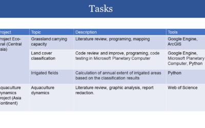
On Tuesday, February 27 at 12:00 Luisa Pflumm will present her innolab report on developing a processing pipeline to produce photogrammetry products in UAS acquired imagery using Agisoft Metashape software (seminar room 3, John-Skilton-Str. 4a). The work of the...
Inno Lab Report by Helena Wehner on January 23rd at 12:30 p.m.
On Tuesday, January 23rd at 12:30 Helena Wehner will present her inno lab report "Low-Cost UAV for Conservation in the Conservation area „Biosphärenreservat Rhön"" (seminar room 3, John-Skilton-Str. 4a). Hosting Institution: Biosphärenreservat Rhön Supervisors: Jonas...
Internship Report by Luis David Almeida Famada
On Tuesday, January 23rd at 12:00 a.m. Luis David Almeida Famada will present his internship report at DLR " "Land Use and Resource Management" Hosting Institution: DLR – Deutsches Zentrum für Luft- und Raumfahrt Supervisors: Dr. Soner Üreyen, Deutsches Luft- und...
Deep Neural Network Regression for Normalized Digital Surface Model Generation with Sentinel-2 Imagery
Our EAGLE student Konstantin Müller published together with our chairholder of the Deparment of Global Urbanization and Remote Sensing, Hannes Taubenboeck an article about DL for surface model generation. The article explores methods to extract high-resolution...
MSc defense by Joy Giovanni Matabishi
On Tuesday, October 31, 2023 at 12 a.m Joy-Giovanni Matabishi will present his Msc Thesis “Modelling Bat Distribution and Diversity with Artificial light as a Focal Predictor in South Tyrol” in the seminar room 3 in John-Skilton-Str. 4a/ground floor. Modelling Bat...
MSc defense by Vanessa Rittlinger
On Tuesday, October 24, 2023 at 12:00 a.m. Vanessa Rittllinger will present her master thesis on “Detection of landslides in space and time using optical remote sensing data – A case study in South Tyrol” in seminar room 3 in John-Skilton-Str. 4a/ground floor From the...
MSc defense by Moritz Rösch
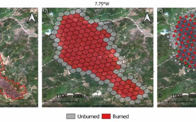
On Tuesday, November 27 at 12:00 a.m., 2023 Moritz Rösch will present his MSc defense “Daily spread prediction of European wildfires based on historical burned area time series from Earth observation data using spatio-temporal graph neural networks” in the seminar...
Internship Report
On Tuesday, December 12, 2023 at 12:00 a.m. Sunniva McKeever, Maximilian Merzdorf, and Isabella Metz will present their internship report on their internship at the Kruger National Park, South Africa in seminar room 3 in John-Skilton-Str. 4a/ground floor Subject: "Our...
Internship Report by Christobal Tobbin
On Tuesday, November 28, 2023 at 13:00 Christobal Tobbin will present his internship report on his internship at DLR “The CONCERT Project” in seminar room 3 in John-Skilton-Str. 4a/ground floor. From the abstract: The CONCERT project with the Agriculture and...