
On October 29, 2024 Subarno Shankar will present his master thesis ” Discovering Hydrographic Parameters of HydroSHEDS and TanDEM-X Digital Elevation Model through Exploratory Data Analysis” at 12:00 seminar room 3, John-Skilton-Str. 4a.
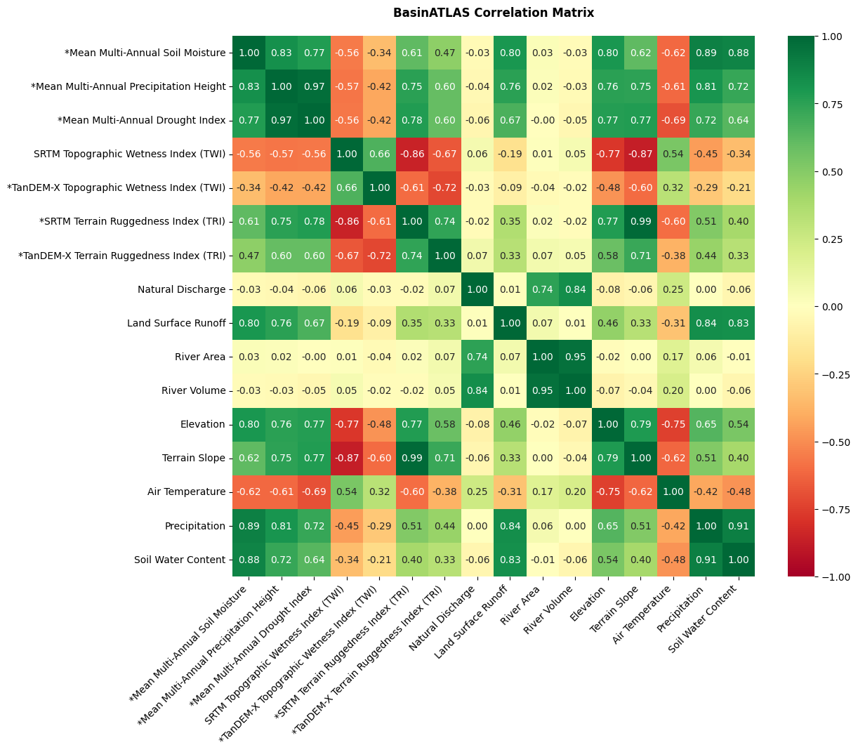
From the abstract: Climate change and anthropogenic factors, including groundwater pumping, deforestation, urbanization, and agriculture, impact the fluvial systems and cause degradation of the ecosystem. This study demonstrates the development and incorporation of geomorphometric parameters, including the Topographic Wetness Index (TWI), Terrain Ruggedness Index (TRI), and Geomorphons from the SRTM and TanDEM-X digital elevation models (DEM) into a hydro-environmental dataset termed HydroSHEDS by leveraging a hybrid workflow of QGIS and Python at a catchment scale. Additionally, the relationship of geomorphometric parameters with multi-annual environmental variables, including Soil Moisture, Precipitation Height, and Drought Index obtained from DWD and various hydro environmental features from HydroSHEDS based on environmental variables is investigated utilizing the Exploratory Data Analysis (EDA) techniques such as Descriptive Statistics, Correlation, Multiple Regression, and Clustering. The correlation analysis of environmental variables with geomorphometric parameters and hydro-environmental variables at a catchment scale indicates a moderate to strong relationship for most attributes, where SRTM exhibits a higher correlation with environmental variables than TanDEM-X. The multiple regression prediction scores for Soil Moisture (R2 = 0.94, RMSE = 0.03), Precipitation Height (R2 = 0.88, RMSE = 86.61), and Drought Index (R2= 0.86, RMSE = 6.83) indicate a strong relationship with geomorphometric parameters and BasinATLAS hydro-environmental variables. The clustering analysis using k-means clustering a silhouette score (0.52) indicates the moderate grouping of predicted catchments based on their hydrographic features. Overall, the results indicate favourable workflow compatibility for deriving and incorporating geomorphometric parameters in HydroSHEDS at a catchment scale.
1st supervisor: Prof. Dr. Tobias Ullmann 2nd supervisor: Leena Julia Warmedinger, DLR
From the abstract: Climate change and anthropogenic factors, including groundwater pumping, deforestation, urbanization, and agriculture, impact the fluvial systems and cause degradation of the ecosystem. This study demonstrates the development and incorporation of geomorphometric parameters, including the Topographic Wetness Index (TWI), Terrain Ruggedness Index (TRI), and Geomorphons from the SRTM and TanDEM-X digital elevation models (DEM) into a hydro-environmental dataset termed HydroSHEDS by leveraging a hybrid workflow of QGIS and Python at a catchment scale. Additionally, the relationship of geomorphometric parameters with multi-annual environmental variables, including Soil Moisture, Precipitation Height, and Drought Index obtained from DWD and various hydro environmental features from HydroSHEDS based on environmental variables is investigated utilizing the Exploratory Data Analysis (EDA) techniques such as Descriptive Statistics, Correlation, Multiple Regression, and Clustering. The correlation analysis of environmental variables with geomorphometric parameters and hydro-environmental variables at a catchment scale indicates a moderate to strong relationship for most attributes, where SRTM exhibits a higher correlation with environmental variables than TanDEM-X. The multiple regression prediction scores for Soil Moisture (R2 = 0.94, RMSE = 0.03), Precipitation Height (R2 = 0.88, RMSE = 86.61), and Drought Index (R2= 0.86, RMSE = 6.83) indicate a strong relationship with geomorphometric parameters and BasinATLAS hydro-environmental variables. The clustering analysis using k-means clustering a silhouette score (0.52) indicates the moderate grouping of predicted catchments based on their hydrographic features. Overall, the results indicate favourable workflow compatibility for deriving and incorporating geomorphometric parameters in HydroSHEDS at a catchment scale.
1st supervisor: Prof. Dr. Tobias Ullmann 2nd supervisor: Leena Julia Warmedinger, DLR




![[Spotlight] Lecturer Spotlight: Julian Faeth](https://eagle-science.org/wp-content/uploads/2026/10/Julian_Faeth_EORC_EAGLE_2026-400x250.jpg)



