Annika will present her M.Sc. thesis “Analysis of alpine grassland management dynamics based on webcam and optical remote sensing time series” on Friday 9th of September at 9am. From the abstract:
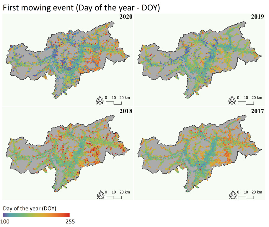
“The aim of this study is to detect relationships between environmental parameters, the mowing frequency and timing of the mowing events over the years 2017 to 2020. The approach is based on an automated detection of mowing events for the alpine region, using South Tyrol as a study area. As a data basis, a dataset derived from webcam and Sentinel-2 and Landsat-8 data is used.
The assumption is that climate fluctuations cause changes in terms of mowing frequency and timing as part of the grassland management. In relation to these fluctuations, the drivers that cause them are analysed to show that grassland management is influenced by environmental parameters. This question is of interest, because climatic change heavily affects the alpine region, which is strongly characterized by grasslands. Furthermore, grasslands fulfill many ecosystem services and are therefore of importance.
In the first step, a method for the detection of mowing events is transferred to the alpine region and validated. It is shown that especially for the first and second mowing event the method can be transfer and achieves even better results than the analysis in the initial region. However, the deviations for further mowing events are very high. By further optimizing of the parameters and the extension of the data sources, the result could be optimized in a follow-up study.
Through the next step of the analysis, relations between the mowing frequency, the timing of the first mowing and the derived environmental parameters could be revealed. For all years a correlation between elevation, temperature and mowing activities is shown. Further weather fluctuations between the years lead to changes in the composition of the important variables for the timing and frequency of mowing events.”
supervisors: Dr. Ruth Sonnenschein (EURAC), Dr. Martin Wegmann