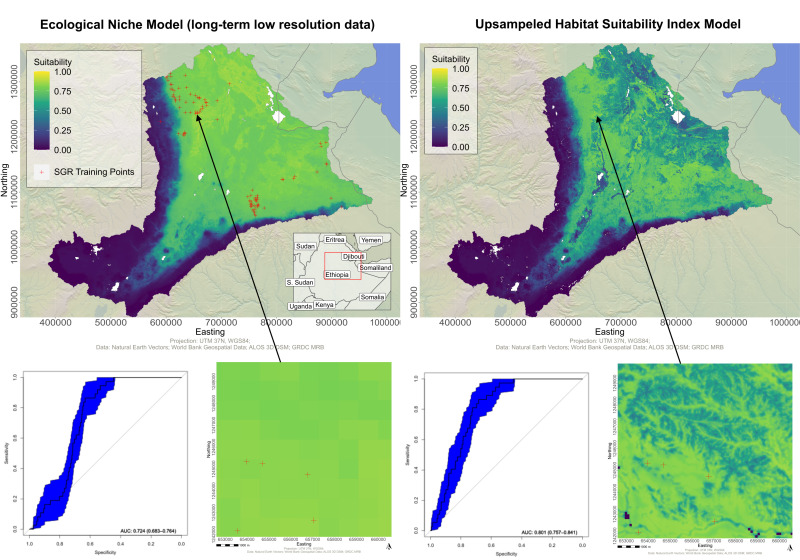
Frederic Schwarzenbacher will defend his M.Sc. thesis on Monday 6th at 3pm. The title is “Habitat suitability modeling for Desert Locust in the Awash River basin: Estimation of the breeding probability based on remote sensing, climatology and environment data” and more details in the abstract: ” Desert Locust outbreaks in Africa and at the Arabian Peninsula are a recurring threat to humans, the economy, and the environment. Over the last century, an increased knowledge about the species allowed to develop frameworks to counterfight the episodic invasion phases. Since the 1980s, remote sensing data is operatively used to monitor and forecast Desert Locust breeding and migration. The availability of high resolution satellite sensors has led to an increased effort in research to derive habitat descriptors, such as vegetation coverage or soil moisture, from remote sensing data. However, long-term geospatial ecological data usually have a low spatial resolution. In this work, the breeding habitat of Desert Locust is mapped by a two-step procedure. At first, several Ecological Niche Models (ENMs) algorithms are used to create a low to medium resolution map of areas that are suitable for Desert Locust breeding. In a following procedure, the results from the ENMs are jointly integrated in a Habitat Suitability Index (HSI) together with additional high resolution data, including yearly Perpendicular Vegetation Index (PVI) composites. A sensitivity analysis in this work showed that the PVI outperforms other more commonly used vegetation indices in arid and semiarid areas which characterize the Desert Locust habitat. Furthermore, the integration of high resolution data to a HSI has led to an increased model accuracy (AUC: 0.801) compared to the ENM results (AUC: 0.724) on the spatial scale of the study area. The improvement of the evolution metric is very significant (P<0.0025).”
1st Supervisor: Dr. Martin Wegmann
2nd Supervisor: Dr. Felix Bachofer (DLR)
Mentor: Igor Klein (DLR)