Aim
Modern exploration for georesources is based on the spatial quantification of all those geological parameters relevant to the formation of mineral deposits. The students will obtain knowledge of the methods that can be applied to the formulation of mineral potential maps for a given region.
Content
Mineral deposits are considered products of complex mineral systems, which can be described by a number of parameters that vary in space and time. Various methods of spatially quantifying these parameters and integrating them into mineral potential maps will be discussed and applied with the help of conventional GIS software.
Coding
Coding examples and individual work will be covered
Software
Various software programs will be used, but mainly OpenSource software such as R.
Techniques
Different techniques will be introduced and practically applied.
Content
The content of scientific with regard to the audience will be discussed.
General Course News and Updates
Research by Jannis Midasch presented at Archaelogy conference
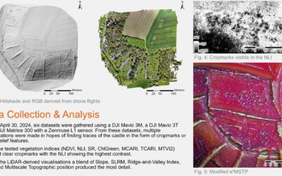
Our EAGLE student Jannis Midasch presented his work on "Rediscovering a lost medieval castle using GIS and UAS-based remote sensing" at the Annual Meeting of the Aerial Archaelogy Research Group in York, UK this September. Jannis used various UAS/drone based...
Summer School of Alpine Research
Last week, Laura, an 8th gen EAGLE Student, participated in the Summer School of Alpine Research, conducted by the University of Innsbruck, in the beautiful location of the Austrian Oetztal in Obergurgl. The focus of the Summer School was on Close Range Sensing...
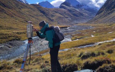
EAGLE M.Sc. thesis in the Arctic
Our EAGLE student Ronja Seitz is conducting her field work for her Master thesis in the Arctic, on Svalbard. She started collecting her data in June to build up a timeseries with UAS multispectral data to investigate disturbances like rain on snow (ROS) events and...
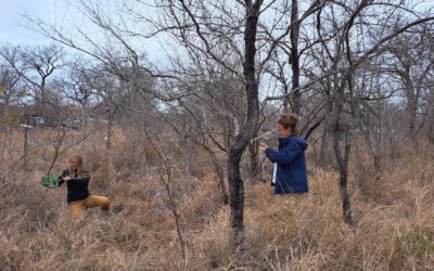
Our Earth Observation students doing their internship with SANparks, South Africa
Our EAGLE M.Sc. students Marlene Bauer and Anna Bischof are currently doing their internship at SANparks, in the Kruger National Park, South Africa. After some intense months of preparation guided by their EORC supervisor Dr. Mirjana Bevanda and supported by the PhD...
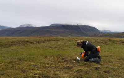
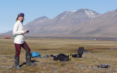
Our EAGLE Clara is doing her internship in the Arctic
Clara, an 8th gen EAGLE, is currently doing her internship in the Arctic. She spends 2 months in Longyearbyen on Svalbard where she works with colleagues from UNIS who are already collaborating with our EORC scientists, namely Dr. Bevanda. Clara works at the Arctic...
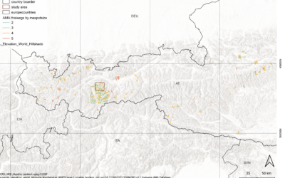
Master Defense: Towards a quantitative terrain-based avalanche size classification: a case study based on Avalanche Modelling Atlas Thalweg data
On September 18, Magdalena Fischer will present her master thesis " Towards a quantitative terrain-based avalanche size classification: a case study based on Avalanche Modelling Atlas Thalweg data" at 13:00 in seminar room 3, John-Skilton-Str. 4a. From the...
Master Defense: Comparing the suitability of remote sensing and wildlife camera time series for deriving phenological metrics of understory vegetation in temperate forests of Upper Franconia, Bavaria
On September 18, Sarah Schneider will present her master thesis "Comparing the suitability of remote sensing and wildlife camera time series for deriving phenological metrics of understory vegetation in temperate forests of Upper Franconia, Bavaria" at 14:00 in...
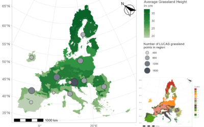
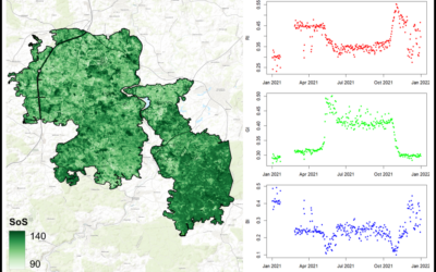
Master Defense: Regionalisation and Characterisation of Grasslands in the EU based on Remote Sensing Data
On September 17, Daniel Gruschwitz will present his master thesis " Detection of hedgerows and copses in the agricultural landscape of Lower Franconia (Germany) using earth observation data" at 13:30 in seminar room 3, John-Skilton-Str. 4a. From the abstract: In the...
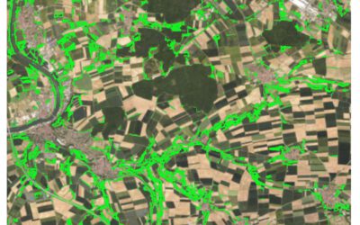
Master Defense: Detection of hedgerows and copses in the agricultural landscape of Lower Franconia (Germany) using earth observation data
On September 17, Verena Stegmaier will presenter her master thesis " Detection of hedgerows and copses in the agricultural landscape of Lower Franconia (Germany) using earth observation data" at 12:30 in seminar room 3, John-Skilton-Str. 4a. From the abstract:...
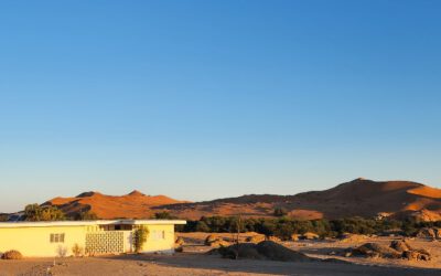
Cooperation with Namib desert Research Institute Gobabeb
The Namib desert research station Gobabeb (www.gobabeb.org) is involved in diverse research projects and is hosting various students and researchers from a wide range of backgrounds and nationalities. They are also already involved in remote sensing and very...