Aim
The module addresses methods on how Earth Observation and the use of geoinformation can support different fields of land and water management. The students will be guided to gain knowledge in selected practical examples.
Content
A general introduction on the subject, which strongly integrates large fields of environmental sciences and studies, is given. The students select topics in which remote sensing and geoinformation can significantly contribute parameters for answering relevant management questions. The topics include the derivation and use of parameters for monitoring land and/or water resources and examples how they can actually implemented in analytical or predictive models, or in indicator systems. The examples may include the management of the resources in rangelands, croplands, irrigation and drainage systems, river catchments, urban areas, or others. Focus may be set on special geographical settings. Depending on the selected topics and scale relevant Earth Observation parameters can include land cover and land use mapping, biophysical variables (LAI/FPAR/Chlorophyll, evapotranspiration , etc.), biomass or crop yields, soil moisture, phenological metrics and other dynamic parameters.
Coding
Software
Techniques
Content
General Course News and Updates
MSc defense by Salim Soltani
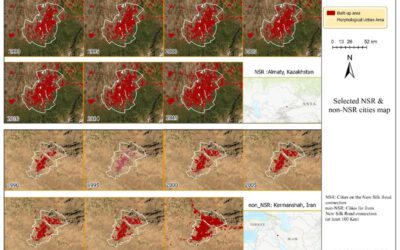
Selected map of NSR and non_NSR cities from 1990-2019, NSR cities represent the cities located directly on the New Silk Road , and non_NSR cities represent cities located far from( at least 100 Km) the New Silk Road. Salim Soltani will defend his M.Sc. thesis...
New EAGLEs in 2020
we are finally through all 140 interviews of eligible EAGLE applications. We had again very good and highly suitable candiates and in total 25 applicants passed the interviews and are accepted to the EAGLE program. Our new EAGLEs are from various countries (15...
M.Sc. Defense by Felix Glasmann
Felix Glasman will defend his M.Sc. thesis "The FireBIRD Mission: Potential for the Detection of Gasflaring" on Thursday 30th of July at 11am. From his abstract: "The controversial but widespread process of gas flaring has received growing attention over the recent...
Internship presentations
On Thursday 30th at 10 am the following EAGLE students will present their internships or inno labs: Tobias Gutzmann: 'Aerial Image Analysis for WW2 Warfare Material Detection' at Luftbilddatenbank Henrik Fisser: 'Sentinel-2 Truck Detection - Sensing Trade from Space...
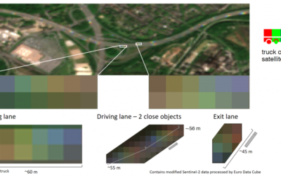
EAGLE student Henrik Fisser won ESA competition
Congratulations to Henrik Fisser, whose Sentinel-2 analysis on truck detection has been awarded the first prize for the European Data Cube COVID-19 contest! He uses the reflectance patterns of long moving vehicles in Sentinel-2 images. Please see the ESA webpage for...
MSc defense by Katrin Hasenbein
Katrin Hasenbein will defend her M.Sc. thesis on Thursday 12am on "The potential to enhance land use mapping by leveraging processing methods of time series data". from the abstract: "With the launch of the twin satellites of Sentinel-2 time series data with a high...
2020 applications
We received again a high number of very good applicants and are currently working through all application files. We will invite all eligible applicants in the next weeks for an interview. In total we received 137 eligible applications from the EU as well as North and...

MSc idea presentation by Aida Taghavi
Aida will present on Friday, May 22nd at 2:30pm her MSc idea "Potentials of Cosmic-Ray Neutron Probes for Assessing and Mapping SAR-based Soil Moisture in a Mediterranean agro-forestry ecosystem by developing an integrated ground- and space-based Modelling Framework"....
Sebastian Buchelt successfully presented his MSc thesis
Sebastian Buchelt successfully presented his MSc thesis - congratulations! Read more about his research project here.
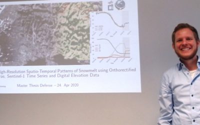
MSc defense by Sebastian Buchelt
Sebastian Buchelt will present his M.Sc. thesis "Analysis of High-Resolution Spatio-Temporal Patterns of Snowmelt using Orthorectified Photo Cameras, Sentinel-1 Time Series and Digital Elevation Data" in a virtual course room. From the abstract: " Snow is one of the...