Aim
In this lecture you will gain a broad overview of the applications of remote sensing. Examples from different disciplines and applied Earth Observation projects will provide your with a comprehensive understanding of if, where and how remote sensing can contribute to qualitative and quantitative assessments of the cryosphere, forest ecosystems, agro-ecosystems, the coastal zone and urban ecosystems; amongst others. We will evaluate the potential of passive and active sensor systems and adress the advantages and shortcomings of existing sensors in the optical / mutlsispectral, thermal and microwave domain.
Content
This lecture provides knowledge on applications of Earth Observation with a focus on remote sensing of the land surface. Which research questions of different disciplines can be answered by the means of Earth Observation? What are the main approaches? The module links up remote sensing measurements to geo- and biophysical parameters required for further geoanalysis. Commonly used methodological approaches for the derivation of the different parameters are presented. Examples include amongst others applications in geography, environmental planning, ecology, biology, oceanology, soil science, geology, atmospheric science, but also e.g. pollution control (monitoring) and natural resource management. In addition, the module outlines selected examples, how remote sensing technology can be transferred to the workplace of professionals also beyond science, e.g. via the use of geoinformation systems.
General Course News and Updates
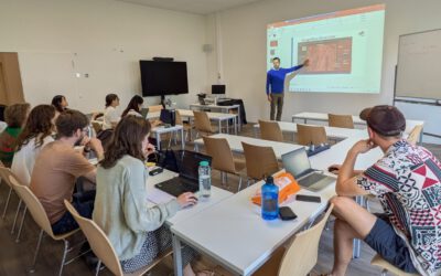
Course on Object-based image analysis
Dr. Michael Wurm from the German Aerospace Center (DLR) gave a class about Object-based image analysis (OBIA) using the eCognition Software for the EAGLE students. The course gives an insight into the theoretical basis of OBIA and using different datasets and tasks...

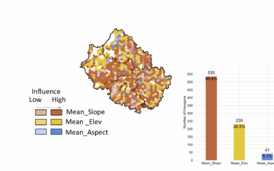
EAGLE Innolab Presentation “Earth observation data cube for the Volcanoes National Park, Rwanda”
On July 15, 2025, Jean de Dieu Tuyizere will present his Innolab results on " Earth observation data cube for the Volcanoes National Park, Rwanda" at 12:00 in seminar room 3, John-Skilton-Str. 4a. From the abstract: The increasing availability of Earth...

EAGLE Innolab Presentation “Earth observation data cube for the Volcanoes National Park, Rwanda”
On July 15, 2025, Jean de Dieu Tuyizere will present his Innolab on " Earth observation data cube for the Volcanoes National Park, Rwanda" at 12:00 in seminar room 3, John-Skilton-Str. 4a. From the abstract: The increasing availability of Earth observation (EO)...

WG: EAGLE Innolab Presentation “Automated Basement Identification in SVI: A Two-Stage Learning Framework”
On July 15, 2025, Gökce Budak will present her Innolab results on " Automated Basement Identification in SVI: A Two-Stage Learning Framework" at 13:00 in seminar room 3, John-Skilton-Str. 4a. From the abstract: The presence of a basement, a structural attribute not...
EAGLE Master Thesis Presentation “Ability of Random Forest Model to Predict the Mean and Standard Deviation of Winter Wheats Biomass in Bavaria: A case study”
On July 08, 2025, Sharmin Mim will defend her master thesis on "Ability of Random Forest Model to Predict the Mean and Standard Deviation of Winter Wheats Biomass in Bavaria: A case study " at 13:00 in seminar room 3, John-Skilton-Str. 4a. From the abstract:...
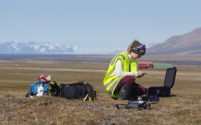
EAGLE Innolab Presentation “Ecology fieldwork in the high Arctic – A drone, tundra and reindeer”
On July 08, 2025, Ronja Seitz will present her Innolab on " Ecology fieldwork in the high Arctic - A drone, tundra and reindeer" at 12:00 in seminar room 3, John-Skilton-Str. 4a. From the abstract: Spitsbergen is the biggest island of the Svalbard archipelago,...
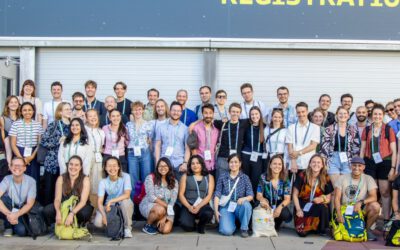
EORC Staff and EAGLE Students at ESA Living Planet Symposium 2025
This week, our EORC team and EAGLE MSc students are joining the global Earth observation community at the ESA Living Planet Symposium (LPS) 2025 — one of the most important gatherings for Earth system scientists, remote sensing experts, and space agencies worldwide....
EAGLE Master Defense: Quantification of Plant Functional Groups and Disturbances of Tundra Vegetation in the High Arctic Using High-Resolution UAV Timeseries Data
On July 01, 2025Ronja Seitz will present her Master Thesis on Quantification of Plant Functional Groups and Disturbances of Tundra Vegetation in the High Arctic Using High-Resolution UAV Timeseries Data " at 12:00 in seminar room 3, John-Skilton-Str. 4a. From...

Alpine Earth Observation: Learning Remote Sensing Where Science Meets Nature
Last week, our Alpine Earth Observation course brought a group of EAGLE students high into the Bavarian Alps, immersing them in a landscape where science and the raw beauty of high Alpine nature meet. Nestled at the Schneefernerhaus research station, the course...
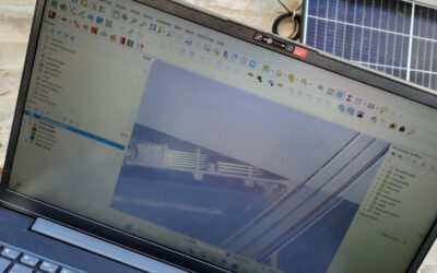
EAGLE Innolab: Development of a QGIS Plugin for the Planning of Ground-Mounted Photovoltaic Systems
On June 16, 2025, Georg Starz will present his Innolab results on " Development of a QGIS Plugin for the Planning of Ground-mounted Photovoltaic Systems " at 10:00 in seminar room 3, John-Skilton-Str. 4a. From the abstract: After a decline in the mid-2010s, the...