Aim
This course provides detailed knowledge of programming or coding using spatial data, especially for remote sensing and GIS tasks.
Content
Different spatial programming approaches are covered using actual remote sensing and GIS data to enable the students to apply a variety of methods in a semi-automatic manner for remote sensing data analysis. All methods will be practically applied during the course using the programming language R and maybe other programs such as GRASS, SAGA, QGIS or OTB. This course continues where the “Programming and Geostatistics” courses stopped and is considered a prerequisite. Both courses are tightly linked
Coding
Software
Techniques
Content
General Course News and Updates

MSc defense Camilo Zamora
On Friday 11th of February at 9am Camilo Zamora will present his M.Sc. thesis "Deforestation dynamics in the Dry Chaco ecoregion: a three decades of change detection and fragmentation study analysis". From the abtract: "Tropical forests represent 52% of global forests...
MSc idea and interesting presentations
on Friday 18th of February at 9am we will have the following presentations: Jakob Rieser - Thesis Idea: "A Synergistic Use of Optical and SAR Remote Sensing Data for the Long-term Evolution of Biocrusts and their Activity across diverse Dryland Ecosystems"....
Internship, inno lab and MSc. idea
On Monday 17th of January at 9am we will have the following presentations: Luisa Pflumm (MSc. idea presentation): "Assess silver-backed chevrotaindistribution in Nui Chua NP (Vietnam).", supervisors: Insa Otte, Andreas Wilting (IZW) Christopher Chan (Msc. idea...
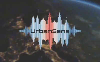
Our EAGLEs featured on the University page
Our EAGLEs Sofia, Annika, Antonio, Andreas and Nils are featured on the University webpage with their UrbanSens idea of combining mobile IoT sensors and Earth Observation data for urban climate monitoring. Their success winning the DLR Copernicus challenge rewarded...
MSc defense by Yomna Eid
Yomna will present her M.Sc. thesis "Assessment of ESA CCI+ and NASA MODIS-LST in Ecological Transects of Australia" on January 14th 2022 at 10am. From the abstract: "Identifying the best-performing MODIS LST products available for scientific analysis is instrumental...
MSc defense by Marius Witt
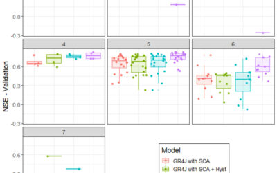
Marius Witt will present his M.Sc. thesis "Investigating discharge dynamics at catchment level usingremote sensing timeseries" on Friday 14th of January 2022 at 9am. From the abstract: The anthropogenic induced climate change is one of the foremost challenges of the...
Our students won the DLR Copernicus challenge 2021!
Great to see again our EAGLE students winning the DLR Copernicus challenge. Last year Henrik Fisser won with his truck detection approach, this year our EAGLE students Sofia Garcia, Annika Ludwig, Nils Karges, Andreas Bury and Antonio Castaneda won the DLR Copernicus...

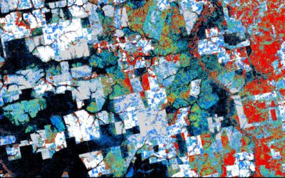
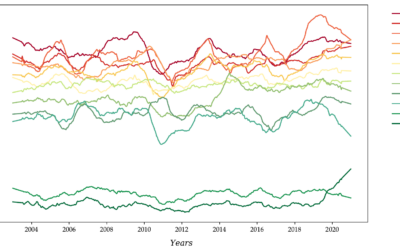
Great dashboard by our EAGLE students
our EAGLE students created various informative remote sensing and spatial environmental data dashboards and learned a lot how to communicate their Earth Observation research in an interactive online platform. One example by our student Ronald Okoth is shown below and...
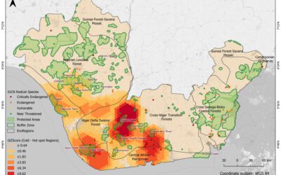
MSc defense by Christabel Ansah
Christabel will present her M.Sc. thesis "ASSESSING THE ENVIRONMENTAL IMPACT OF OIL SPILLS IN THE NIGER DELTA, NIGERIA" on Monday 20th of December at 10am. From the abstract: "The Niger Delta region of Nigeria has been battling with an unprecedented number of oil...
M.Sc. idea presentation by Giovanni Matabishi
On Friday 26th of November at 10am Giovanni will present his M.Sc. idea on "Applying Artificial Light as a Focal Predictor to Model Bat Distribution in South Tyrol". His M.Sc. research is done in collaboration with EURAC research in Bolzano, South Tyrol, Italy. The...