Lecturer
Julia Rieder
ECTS
5 ECTS
Aim
The course provides a practical introduction to LiDAR technology and point cloud analysis. Students gain hands-on experience with LiDAR data, from acquisition principles to processing and interpretation, and learn how LiDAR supports applications such as terrain modelling, forestry, and others. The course emphasizes critical understanding of data quality, limitations, and real-world use cases
Content
This course provides an overview of the scientific field surrounding LiDAR as a key technology for three-dimensional Earth observation. The course covers the fundamentals of LiDAR remote sensing, point cloud data structures, and processing methodologies across platforms ranging from spaceborne and airborne systems to terrestrial and mobile laser scanning. Furthermore, the course highlights current developments and emerging analytical possibilities enabled by advanced point cloud analysis and discusses future potential as LiDAR technologies and methodologies continue to evolve and converge with related disciplines.
Coding
Software
Techniques
Content
General Course News and Updates
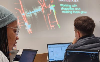
Blender GIS introduction
Within out EAGLE Earth Observation M.Sc. we also cover software applications which might not be used on a regular basis within our field of research but are sometimes highly useful to display our spatial data in a visually appealing way - and also potentially provides...
EAGLE presentation by Gökçe Yağmur Budak
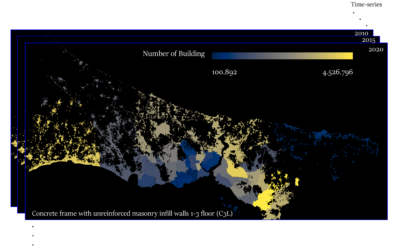
On November 26, 2024, Gökçe Yağmur Budak will present her internship results on " Leveraging Data-Driven Approaches for Seismic Risk Assessment in Istanbul " at 12:30 in seminar room 3, John-Skilton-Str. 4a. From the abstract: This internship aims to create time...
Internship presentation by Jean de Dieu Tuyizere: Mapping leaf area index in Ghana and Senegal using Gaussian process regression and Sentinel-2 Imagery
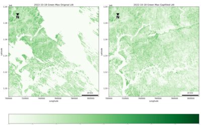
On November 26, 2024, Jean de Dieu Tuyizere will present his internship results on " Mapping leaf area index in Ghana and Senegal using Gaussian process regression and Sentinel-2 Imagery" at 12:00 in seminar room 3, John-Skilton-Str. 4a. From the abstract: This study...
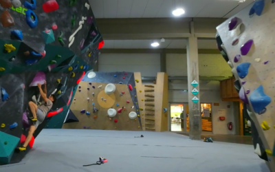
social bouldering event
Last Friday did we organize again a social event for all staff members and EAGLEs to get to know the new students, meet and chat with old students and just have a nice time outside the office for all staff members. We spend 4 hours together in the Rock In boulder gym...
Innolab presentation: Deep Learning-driven Image Super-Resolution for TerraSAR-X
On November 05, 2024, Jannik Hoffmann will present his InnoLab results on " Deep Learning-driven Image Super-Resolution for TerraSAR-X" at 12:00 in seminar room 3, John-Skilton-Str. 4a. From the abstract: High-resolution satellite Synthetic Aperture Radar (SAR) data...
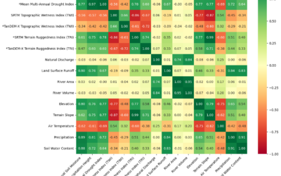
Master Defense: Discovering Hydrographic Parameters of HydroSHEDS and TanDEM-X Digital Elevation Model through Exploratory Data Analysis” at 12:00 seminar room 3, John-Skilton-Str. 4a.
On October 29, 2024 Subarno Shankar will present his master thesis " Discovering Hydrographic Parameters of HydroSHEDS and TanDEM-X Digital Elevation Model through Exploratory Data Analysis" at 12:00 seminar room 3, John-Skilton-Str. 4a. From the abstract: Climate...
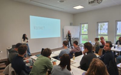
Welcome of new EAGLEs
The EAGLEs from the last generation welcomed our new earth observation students to the EAGLE M.Sc. program and gave them a glimpse of their last 12 months - from coding to socialising, pub crawls to joint hikes and also a lot of best wishes from all the other EAGLEs...
Research by Jannis Midasch presented at Archaelogy conference
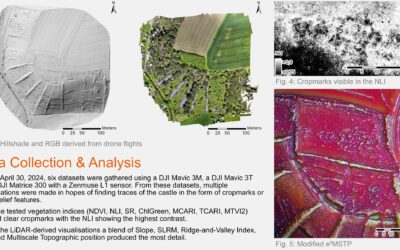
Our EAGLE student Jannis Midasch presented his work on "Rediscovering a lost medieval castle using GIS and UAS-based remote sensing" at the Annual Meeting of the Aerial Archaelogy Research Group in York, UK this September. Jannis used various UAS/drone based...
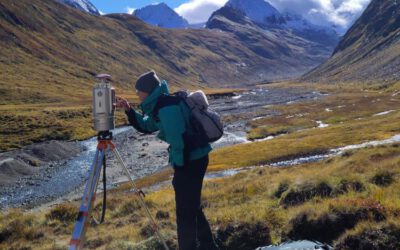
Summer School of Alpine Research
Last week, Laura, an 8th gen EAGLE Student, participated in the Summer School of Alpine Research, conducted by the University of Innsbruck, in the beautiful location of the Austrian Oetztal in Obergurgl. The focus of the Summer School was on Close Range Sensing...
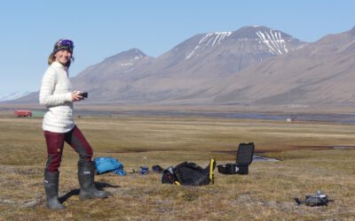
EAGLE M.Sc. thesis in the Arctic
Our EAGLE student Ronja Seitz is conducting her field work for her Master thesis in the Arctic, on Svalbard. She started collecting her data in June to build up a timeseries with UAS multispectral data to investigate disturbances like rain on snow (ROS) events and...