Aim
Managing scientific projects as well as project proposals and developing them towards successful science is a common task for scientists as well as practitioner. In this course different approaches will be introduced and discussed.
Content
Research does mean much more than identifying crucial research question, finding appropriate data, developing algorithms and deriving new findings. While this course will contain all mentioned issues it will beyond highlight the challenges for raising money for research, writing proposals, building up networks, writing papers and doing presentations. All topics will be introduced by the examples of currently running research projects.
General Course News and Updates
Master Thesis Defense: Unmasking the Shadow Economy in Ghana: Mapping The Distribution of Umbrella Covered Informal Vendors In Kumasi
On Tuesday, April 30, at 13:00 Prince Lartey Lawson will present his master thesis on " Unmasking the Shadow Economy in Ghana: Mapping The Distribution of Umbrella Covered Informal Vendors In Kumasi " in 01.B.03 Meeting Room 1st Floor, John-Skilton-Str. 4a. From the...
Master Thesis Defense: “Flood susceptibility mapping using remote sensing and geospatial data in West Africa “
On Tuesday, April 30, at 12:00 Wilmer Fabián Montién Tique will present his master thesis on " Flood susceptibility mapping using remote sensing and geospatial data in West Africa " in 01.B.03 Meeting Room 1st Floor, John-Skilton-Str. 4a. Abstract: Floods in West...

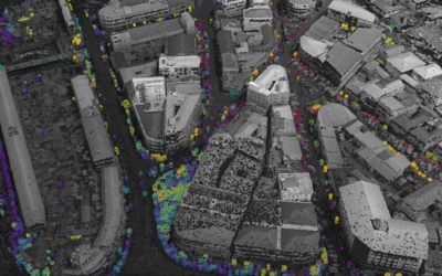
EAGLE workshop on Earth Observation application
Our first EAGLE workshop on Earth Observation applications covered various topics. After a heartily welcome by Tobias Ullmann did more than 50 participants listen to the following talks: Ása Aðalsteinsdóttir: “SAR Monitoring in Iceland” Katrin Wernicke:...

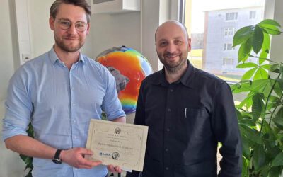
DGPF award for our EAGLE MSc Luisa Wagner
We are very happy to congratulate our former EAGLE student Luisa Wagner for the 2nd prize of the Karl‐Kraus‐Nachwuchsförderpreis 2024. Luisa received this award for her M.Sc. thesis which she handed in early last year on "Analysis of ice shelf front dynamics in Pine...

Master Thesis Defense: “Modelling the Spatio-Temporal Suitability of Urban Environments for Aedes Aegypti Mosquitoes based on their Bio-Ecological Characteristics in Rio de Janeiro “
On Friday, March 22, at 12:00 Rutendo Mukaratirwa will present her master thesis on " Modelling the Spatio-Temporal Suitability of Urban Environments for Aedes Aegypti Mosquitoes based on their Bio-Ecological Characteristics in Rio de Janeiro " in seminar room 3,...
Master Thesis Defense: “Development of Caribbean Seagrass Ecosystem Accounts fusing Earth Observation with Biophysical Modeling of Coastal Carbon” on Tuesday, March 19, 2024
On Tuesday, March 18, at 15:00 Andrea Cárdenas Reyes will present her master thesis on "Development of Caribbean Seagrass Ecosystem Accounts fusing Earth Observation with Biophysical Modeling of Coastal Carbon" in seminar room 3, John-Skilton-Str. 4a. ...
Andreas Bury successfully defended his MSc thesis
Andreas Bury successfully defended his MSc thesis "Assessing Air Pollution in Urban Environments: A Comprehensive Analysis Using Earth Observation and In Situ Measurements" at the EAGLE colloquium on the 8th of March 2024. His research offers an approach to...
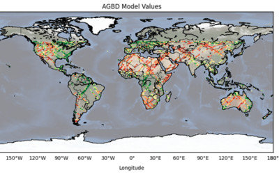
Master Thesis Defense: “CNN-based Global Aboveground Biomass Estimation using Sentinel-2 and GEDI” on Tuesday, March 12, 2024
On Tuesday, March 12, at 12:00 Ka Hei Chow will present her master thesis on " CNN-based Global Aboveground Biomass Estimation using Sentinel-2 and GEDI" in seminar room 3, John-Skilton-Str. 4a. Abstract: Accurate global estimation of aboveground biomass...
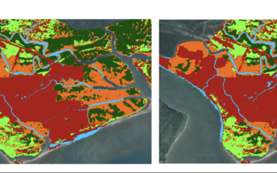
Master Thesis Defense: “Assessing the Mangrove Ecosystem in Eastern Obolo, Niger Delta” on Monday, March 18 at 11:30
On Monday, March 18, at 11:30 Hyeonmin Kang will present her master thesis on "Assessing the Mangrove Ecosystem in Eastern Obolo, Niger Delta" in seminar room 3, John-Skilton-Str. 4a. From the abstract: This study focuses on assessing the mangrove ecosystem in Eastern...

Master Thesis Defense: “Assessing Air Pollution in Urban Environments: A Comprehensive Analysis Using Earth Observation and In Situ Measurements” on Friday, March 08 at 13:00
On Friday, March 08, at 13:00, Andreas Bury will present his master thesis on "Assessing Air Pollution in Urban Environments: A Comprehensive Analysis Using Earth Observation and In Situ Measurements" in seminar room 3, John-Skilton-Str. 4a. From the...