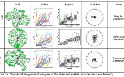
Aim
The students will learn to design scientifically relevant presentations.
Presentations, approaches and layouts as well as programs will be discussed with regard to its scientific content and goal to ensure high quality presentations and dissemination of relevant information.
Content
Visual scientific presentation skills will be taught. Existing presentations will be discussed and evaluated with regard to visual appearance, scientific content and dissemination. Moreover design and appearance of presentations and poster will be discussed and guidelines provided. Individual training of presentations using a variety of programs will be part of it as well. Alternative presentation methods will be introduced (e.g. knitr, beamer).
Coding
Visual as well as coding approaches for presentations are covered
Software
Various software programs will be used, but mainly R with knitr, markdown, slidify etc. or Latex Beamer
Techniques
Different visualisation, oral presentation as well as preparation techniques will be introduced and practically applied.
Content
Theoretical and practical background of scientific presentations and their underlying assumptions and software are covered
General Course News and Updates

M.Sc. thesis presentation by Karsten Wiertz
Karsten Wiertz will present his M.Sc. thesis on Wednesday 14th at 11am in room 0.004 KW 86 with the title "Development of a semi-automatic remote sensing approach for change- detection of forest structures in Bialowieza Forest." From the abstract: The diversity of...

M.Sc. thesis defense by Sebastian Roersch
Sebastian Roersch will defend his thesis "Development of a semi-automated method to measure solar potential" next Wednesday (14th) at 10 am in 0.004 OKW 86. From his abstract: "In the second half of the 21st century, it will be decided how big the impact of climate...
M.Sc. presentation by Marina Reiter
Marina Reiter will present her M.Sc. thesis "Comparing Urban Green Spaces in German Cities Using Remote Sensing Data" on Thursday 8th of August at 11am in OKW 86, 0.004. Looking forward to a great presentation and lively discussion afterwards. From her abstract: "The...
EAGLE presentations
A wide range of internships, innovation labs and M.Sc. idea presentations will take place next Monday (July 29th) in room 0.004, OKW 86. Everybody is invited to join the presentations and discussions: Morning session (10am - 12pm): Katrin Hasenbein (internship)...
M.Sc. defense by Bharath Selvaraj
Bharath Selvaraj will defend his M.Sc. thesis on August 8th at 10am in room 0.004. From the abstract of his thesis: "Over the centuries, humanity made immeasurable progress in both technological innovation and medicine. This progress comes at the cost of environmental...
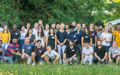
EAGLE Summer Dialogue 2019
Our 2019 EAGLE Summer Dialogue was a great success again and thanks a lot to all our EAGLE students who organised it. More than 100 participants enjoyed talks by Sandra Lohberger (RSS GmbH) and Alfred Schumm (WWF) who covered beside the technical aspects of their work...
Field Work Course 2019
Within the EAGLE program many Earth Observation applications and techniques are introduced and practically executed with quite some computer work. However, remote sensing research also requires a sound understanding of the study area. Field work is therefore a crucial...
Internship and Innovation Lab presentations
on Monday 15th of July at 10 a.m. in room 0.009 (OKW 86) we will have another series of internship and innovation lab presentations plus on M.Sc. idea presentation: (Internship) Marius Philipp -- "Mono Delta Monitoring System (MODES)" (Internship) Silvan...
Innovation Lab and thesis presentation
On Thursday 27th of June at 10am in room 0.004 (OKW 86) the following students will present their M.Sc. idea and their innovation lab outcome: Thesis idea presentation by Johni Miah:"Detecting and Assessing Ground Subsidence of Dhaka City, Bangladesh, using Synthetic...
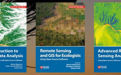
textbooks on remote sensing
Our already published textbook on "Remote Sensing and GIS for Ecologists - using Open Source software" was very well perceived and we got very positive feedback. However, either an introduction or more advanced methods and data was asked for as well. Hence, we decided...