Aim
Designing scientific graphics that provide all necessary information without being too packed, focusing on the essential message and being able to actually create such graphics will be covered In this class. All necessary tools and and approaches to create adequate figures and maps will be covered.
Content
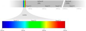
figure from the book “Remote Sensing and GIS for Ecologists” by Wegmann, Leutner and Dech, created with tikz
General guidelines of scientific graphics and maps will be covered based on e.g. Tufte and followed by practical implementation of graphic ideas, as well as critical evaluation of the results. Only open source program will be used such as R or tikz/pgf and students will have the opportunity to work specifically on certain scientific graphics or maps using e.g. ggplot2 and explore the potential and limits of good scientific graphs. Good map designs will be discussed as well and common mistakes will be pointed out. After this course you will be capable to create your own graphics for a specific scientific purpose e.g. your M.Sc. thesis.
Coding
Software
Techniques
Content
General Course News and Updates
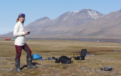
EAGLE M.Sc. thesis in the Arctic
Our EAGLE student Ronja Seitz is conducting her field work for her Master thesis in the Arctic, on Svalbard. She started collecting her data in June to build up a timeseries with UAS multispectral data to investigate disturbances like rain on snow (ROS) events and...
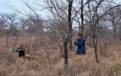
Our Earth Observation students doing their internship with SANparks, South Africa
Our EAGLE M.Sc. students Marlene Bauer and Anna Bischof are currently doing their internship at SANparks, in the Kruger National Park, South Africa. After some intense months of preparation guided by their EORC supervisor Dr. Mirjana Bevanda and supported by the PhD...
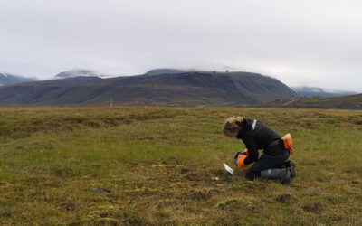
Our EAGLE Clara is doing her internship in the Arctic
Clara, an 8th gen EAGLE, is currently doing her internship in the Arctic. She spends 2 months in Longyearbyen on Svalbard where she works with colleagues from UNIS who are already collaborating with our EORC scientists, namely Dr. Bevanda. Clara works at the Arctic...
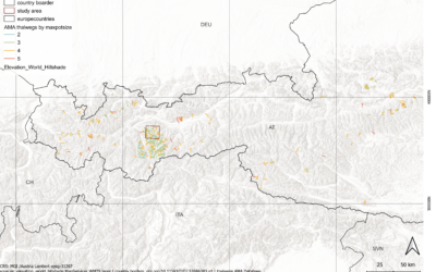
Master Defense: Towards a quantitative terrain-based avalanche size classification: a case study based on Avalanche Modelling Atlas Thalweg data
On September 18, Magdalena Fischer will present her master thesis " Towards a quantitative terrain-based avalanche size classification: a case study based on Avalanche Modelling Atlas Thalweg data" at 13:00 in seminar room 3, John-Skilton-Str. 4a. From the...
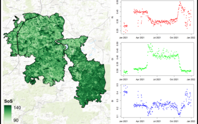
Master Defense: Comparing the suitability of remote sensing and wildlife camera time series for deriving phenological metrics of understory vegetation in temperate forests of Upper Franconia, Bavaria
On September 18, Sarah Schneider will present her master thesis "Comparing the suitability of remote sensing and wildlife camera time series for deriving phenological metrics of understory vegetation in temperate forests of Upper Franconia, Bavaria" at 14:00 in...
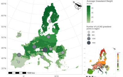
Master Defense: Regionalisation and Characterisation of Grasslands in the EU based on Remote Sensing Data
On September 17, Daniel Gruschwitz will present his master thesis " Detection of hedgerows and copses in the agricultural landscape of Lower Franconia (Germany) using earth observation data" at 13:30 in seminar room 3, John-Skilton-Str. 4a. From the abstract: In the...
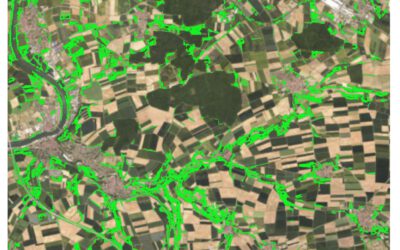
Master Defense: Detection of hedgerows and copses in the agricultural landscape of Lower Franconia (Germany) using earth observation data
On September 17, Verena Stegmaier will presenter her master thesis " Detection of hedgerows and copses in the agricultural landscape of Lower Franconia (Germany) using earth observation data" at 12:30 in seminar room 3, John-Skilton-Str. 4a. From the abstract:...
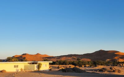
Cooperation with Namib desert Research Institute Gobabeb
The Namib desert research station Gobabeb (www.gobabeb.org) is involved in diverse research projects and is hosting various students and researchers from a wide range of backgrounds and nationalities. They are also already involved in remote sensing and very...
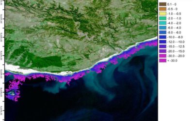
Innolab Presentation: Enhancing Satellite Data Processing for Global Shallow Water Bathymetry at EOMAP
On September 10, 2024, Isabella Metz will present her Inno Lab results on " Enhancing Satellite Data Processing for Global Shallow Water Bathymetry at EOMAP" at 12:00 in seminar room 3, John-Skilton-Str. 4a. From the abstract: About 75% of the oceans have not yet been...
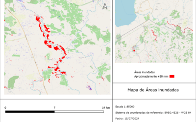
Internship Presentation: Application of synthetic aperture radar (SAR) data: Case study in flood mapping in Costa Rica and technical capacity building of the PRIAS team
On October 01, 2024, Ariana Sofía Argüello Cordero will present her internship " Application of synthetic aperture radar (SAR) data: Case study in flood mapping in Costa Rica and technical capacity building of the PRIAS team" at 12:00 in seminar room 3,...