Aim
The potential and challenges of Unmanned Aerial Vehicles for monitoring our environment is covered using theoretical as well as practical approaches.
Content
In recent years, the use of small Unmanned Aerial Vehicles (UAV, UASs or also called Drones) inceased to map and monitor our environment at unprecedented detail. The development of new multispectral instruments on UAVs have given the remote sensing community exciting opportunities to acquire new data. With these new opportunities also new challenges such as sensor calibration, georeferencing as well as processing workflows, calibration/validation, and derivation of relevant land cover information. The course will cover theory and practice to apply UAVs in environmental research and its use for remote sensing analysis.
Coding
Software
Techniques
Content
General Course News and Updates
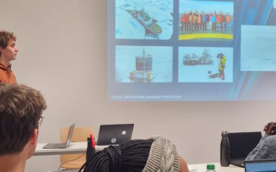
EAGLE alumnus Henrik Fisser presenting polar research
Our EAGLE alumnus Henrik Fisser recently visited us after a research stay in the United States. He is now pursuing his PhD at UiT The Arctic University of Norway, specifically in the Earth Observation Department. UiT is renowned for its cutting-edge research in Earth...
Orfeo Toolbox covered in our courses
As part of our international EAGLE MSc courses, we include comprehensive training on the powerful Orfeo Toolbox (OTB) software. OTB is an open-source library for processing remote sensing imagery, offering advanced algorithms for tasks such as image segmentation,...
EAGLE Internship Presentation ” Research and development of data strategies for disaster management, early warning systems, and refugee data analysis”
On January 07, 2025, Sarah Schneider will present her internship " Research and development of data strategies for disaster management, early warning systems, and refugee data analysis" at 14:00 in seminar room 3, John-Skilton-Str. 4a. From the abstract: The...
Master Thesis Presentation “Animal Path Segmentation and Analysis via Deep Neural Network Regression”
On January 14, 2025, Konstantin Müller will defend his master thesis " Animal Path Segmentation and Analysis via Deep Neural Network Regression " at 12:00 in seminar room 3, John-Skilton-Str. 4a. From the abstract: Animals play a vital role for well-functioning...
Internship network fair
Today, we provided our international Eagle MSc students with access to the professional network of our EORC to assist them in finding suitable internships or MSc thesis topics. Several individuals offered their networks, including Hannes Taubenboeck for georisk and...
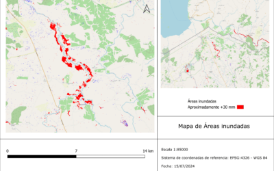
Internship Presentation: Application of synthetic aperture radar (SAR) data: Case study in flood mapping in Costa Rica and technical capacity building of the PRIAS team
On December 17, 2024, Ariana Sofía Argüello Cordero will present her internship " Application of synthetic aperture radar (SAR) data: Case study in flood mapping in Costa Rica and technical capacity building of the PRIAS team" at 12:00 in seminar room 3,...
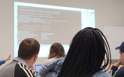
GRASS software for Earth Observation
In our international EAGLE MSc program, we go beyond the limitations of a single programming language or software environment. Our goal is to empower students to leverage a wide range of scientific tools effectively. They gain insight into the strengths and...
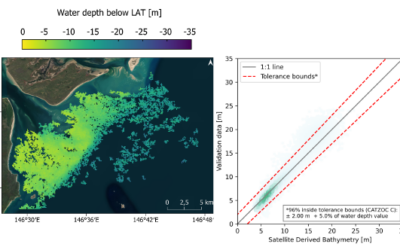
Master Defense by Isabella Metz: ” Analysis of Uncertainties for Error Detection and Quantification of Bathymetry Data from Multispectral Sentinel-2 Imagery
On January 07, 2025, Isabella Metz will defend her master thesis on " Analysis of Uncertainties for Error Detection and Quantification of Bathymetry Data from Multispectral Sentinel-2 Imagery" at 13:00 in seminar room 3, John-Skilton-Str. 4a. From the abstract: In...
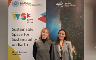
EAGLES rock(et) the World Space Forum 2024
Laura - 8th gen EAGLE and in the last week of her internship at UN-SPIDER - and Sunniva - 7th gen EAGLE and working as a student assistant at the DLR's space agency - together happen to help organize the World Space Forum (WSF) 2024 in Bonn. Surrounded by...
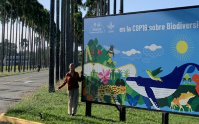
EAGLE internship at CIAT in Colombia
Leonie, an 8th generation EAGLE, is currently doing her internship at CIAT (International Center of Tropical Agriculture) in South America, Colombia. She is part of the Multifuncional Landscapes group, which investigates about soil organic carbon sequestration in...