Aim
The potential and challenges of Unmanned Aerial Vehicles for monitoring our environment is covered using theoretical as well as practical approaches.
Content
In recent years, the use of small Unmanned Aerial Vehicles (UAV, UASs or also called Drones) inceased to map and monitor our environment at unprecedented detail. The development of new multispectral instruments on UAVs have given the remote sensing community exciting opportunities to acquire new data. With these new opportunities also new challenges such as sensor calibration, georeferencing as well as processing workflows, calibration/validation, and derivation of relevant land cover information. The course will cover theory and practice to apply UAVs in environmental research and its use for remote sensing analysis.
Coding
Software
Techniques
Content
General Course News and Updates

Where Learning Meets Friendship
At EAGLE, studying together is only part of the story. Our students are more than classmates — they’re hiking buddies, party companions, and the kind of people who show up to lectures with birthday cakes 🎂. Today was a perfect example. Our EAGLE student...
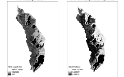
EAGLE Innolab Presentation: “Gap-Filling Optical NDVI Using SAR-Derived Indices and Machine Learning”
On February 10, 2026, Mahnoor Nadeem will present her Innolab results on " Gap-Filling Optical NDVI Using SAR-Derived Indices and Machine Learning" at 12:00 in seminar room 3, John-Skilton-Str. 4a. From the abstract: Normalized Difference Vegetation Index (NDVI) is...
EAGLE Internship Presentation: “Internship at Helmholtz Zentrum Munich”
On February 03, 2026, Agnes Zwick will present her internship "Internship at Helmholtz Zentrum Munich" at 12:00 in seminar room 3, John-Skilton-Str. 4a. From the abstract: From September to October 2025, the internship was completed at the Helmholtz Zentrum München...
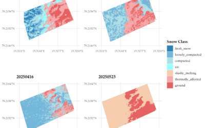
EAGLE MSc Defense: “Assessing the potential of thermal UAS for spatio-temporal Arctic snow monitoring – A pilot study in Bjørndalen, Svalbard”
On February 24, 2026, Lena Jäger will present her Master Thesis on "Assessing the potential of thermal UAS for spatio-temporal Arctic snow monitoring - A pilot study in Bjørndalen, Svalbard" at 12:00 in seminar room 3, John-Skilton-Str. 4a. From the abstract: The...
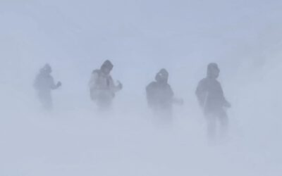
Learning Earth Observation Data Acquisition in Real-World Conditions
As part of our course on Earth Observation data acquisition, EAGLE students experience first-hand that even the best planning is ultimately shaped by the weather. While flight plans, measurement strategies, and schedules can be carefully prepared in advance, field...
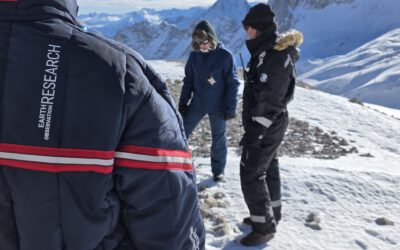
Snow Research at Schneefernerhaus, Zugspitze
Recently, our team carried out another successful field campaign at the Schneefernerhaus research station on the Zugspitze in the Alps. Together with our EAGLE students, we collected UAS-based environmental data alongside detailed in-situ measurements of snow...
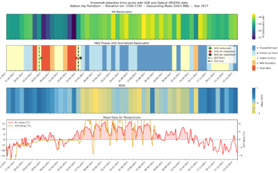
EAGLE MSc Defense: “Detecting Snow Phases and Runoff Using Sentinel-1 SAR and Multispectral–Optical Data”
On December 09, 2025, Daria Ushakova will present her Master Thesis on " Detecting Snow Phases and Runoff Using Sentinel-1 SAR and Multispectral–Optical Data " at 13:00 in seminar room 3, John-Skilton-Str. 4a. From the abstract: Snow is a crucial component of the...
EAGLE Internship Presentation “Detecting Wildfires in Brandenburg, Germany”
On November 18, 2025, Angie Torres will present her internship at " Detecting Wildfires in Brandenburg, Germany" at 12:00 in seminar room 3, John-Skilton-Str. 4a. From the abstract: Wildfires have become an increasing concern in Germany, particularly in the region of...
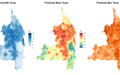
EAGLE MSc Defense “Modeling Urban Heat Exposure and Vulnerability Integrating Citizen Science and VHR Remote Sensing”
On October 22, 2025, Ariana Sofía Argüello Cordero will present her Master Thesis on " Modeling Urban Heat Exposure and Vulnerability Integrating Citizen Science and VHR Remote Sensing" at 10:15 at the EORC Meeting Room (1st floor), John-Skilton-Str. 4a From the...
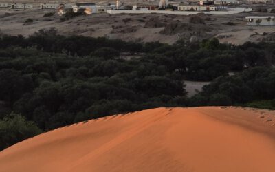
EAGLE Internship Presentation “Gobabeb Namib Research Institute”
On October 21, 2025, Farimah Abdolzadeh will present her internship at " Gobabeb Namib Research Institute " at 12:30 in seminar room 3, John-Skilton-Str. 4a. Farimah has just completed her internship at the Gobabeb Namib Research Institute, located in the heart of...