Aim
The potential and challenges of Unmanned Aerial Vehicles for monitoring our environment is covered using theoretical as well as practical approaches.
Content
In recent years, the use of small Unmanned Aerial Vehicles (UAV, UASs or also called Drones) inceased to map and monitor our environment at unprecedented detail. The development of new multispectral instruments on UAVs have given the remote sensing community exciting opportunities to acquire new data. With these new opportunities also new challenges such as sensor calibration, georeferencing as well as processing workflows, calibration/validation, and derivation of relevant land cover information. The course will cover theory and practice to apply UAVs in environmental research and its use for remote sensing analysis.
Coding
Software
Techniques
Content
General Course News and Updates
🚀 Hats Off to Janik Hoffmann for His Successful MSc Defense! 🛰📈
A big congratulations to Janik Hoffmann, who successfully defended his Master thesis today on the cutting-edge topic: “Deep Learning-driven SAR Image Super-Resolution.” Supervised by Prof. Dr. Tobias Ullmann and Dr. Wolfgang Koppe (Airbus Defence and Space GmbH),...
Behind the Lens: EAGLE Students Marlene & Anna Took Over Uni Würzburg’s Instagram!
What happens when two passionate Earth Observation students take the reins of the University of Würzburg’s Instagram account? A few days full of inspiration, insights, and a whole lot of drone footage! 🌍🚁 EAGLE MSc students Marlene and Anna recently...
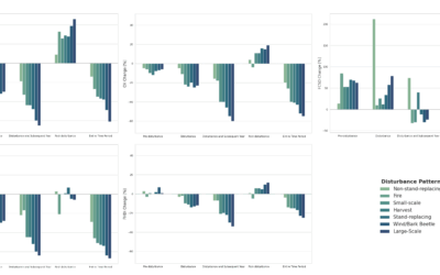
Spatial R Packages Showcase by our EAGLE students
We are very proud to share the diverse submissions of spatial R packages within the EAGLE M.Sc. course of Ariane Droin and Martin Wegmann aiming at advancing our students' knowlege about programming for environmental analysis, geospatial visualization, and ecological...
EAGLE Master Defense: Deep Learning-driven SAR Image Super-Resolution
On May 20, 2025, Janik Hoffmann will present his Master thesis on Deep Learning-driven SAR Image Super-Resolution" at 13:00 in seminar room 3, John-Skilton-Str. 4a. From the abstract: Synthetic Aperture Radar (SAR) is a microwave remote sensing system that is used for...
EAGLE Master Defense: Spatio-temporal Forest Structure Dynamics in Germany: A Synthesis of Remote Sensing Products
On May 20, 2025, Sunniva McKeever will present her Master thesis on " Spatio-temporal Forest Structure Dynamics in Germany: A Synthesis of Remote Sensing Products" at 12:00 in seminar room 3, John-Skilton-Str. 4a. From the abstract: Germany’s forests have experienced...
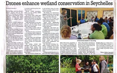
News article: EAGLEs Use Drones for Innovative Conservation Efforts in Seychelles
The work by our interns Anna and Marlene was covered in Seychelles Newspaper. The articles covers how Anna and Marlene successfully utilized drone technology to monitor and assess wildlife and environmental health across the archipelago. Their efforts, supervised by...
Unlock the Power of Earth Observation: Join Our MSc Program to Understand and Protect Our Planet
Are you passionate about understanding the planet's complex systems? Do you want to learn how to apply cutting-edge Earth Observation technologies to address some of the most pressing environmental and societal challenges of our time? If so, our EAGLE MSc in Applied...
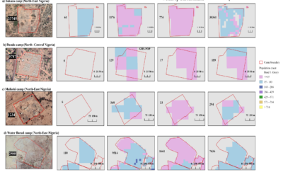
EAGLE Master Theses defense “Revealing Inconsistencies in Population Datasets in Refugee and IDP Camps”
On April 03, 2025, Lallu Nikerthil Prathapan will present her Master Thesis " Revealing Inconsistencies in Population Datasets in Refugee and IDP Camps " at 15:00 in seminar room 3, John-Skilton-Str. 4a. From the abstract: Accurate population estimates are crucial for...
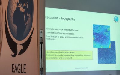
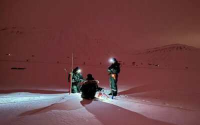
EAGLE MSc Students Present UAS-Based Snow Research at Zugspitze
EAGLE MSc students recently showcased their research findings on snow depth and its driving factors at the Schneefernerhaus Environmental Research Station on Zugspitze, Germany’s highest peak. Their work, conducted under the supervision of PhD students Elio Rauth and...
EAGLE Students Marlene Bauer and Anna Bischof to Participate in ISRSE 2025
We are very pleased to share that two of our students, Marlene Bauer and Anna Bischof, will be actively contributing to the International Symposium on Remote Sensing of Environment (ISRSE) 2025 in the UK next week. As part of their involvement with talks and posters,...