Aim
Aim of this course is to provide you with an overview on geographic processes of urbanization, the related demographic and structural changes of cities, and data analyses methods using remote sensing data for applications in urban geography.
Content
Humankind is within its largest migration ever: from rural areas into cities. The drivers of this global process of urbanization from demographic to economic and the related structural changes cities are facing will be discussed in this course. Remote sensing is one crucial data source in this dynamic transformation and its products are highly relevant for urban planning, as well as environmental management. Within this course different approaches and techniques are covered focusing on deriving relevant information about urbanized areas on different levels of detail. Uni-temporal-, multi-temporal-, and time series based image classification, segmentation, the analyses of point patterns, GIS analyses to assess spatial context and dependencies, as well as analyses in the 3D domain will be addressed in this course. This will be done providing and discussing example applications from different regions globally (e.g. urban sprawl analysis of megacities, the development of new dimensions of urban landscapes such as mega-regions, the rearrangement of business districts within the urban landscape, etc.). You will learn what capabilities Earth observation data, methods and products have for urban research and applications and how to design remote sensing based urban analysis, how to avoid caveats, troubleshoot errors and interpret the results.
General Course News and Updates
MSc defense by Christabel Ansah
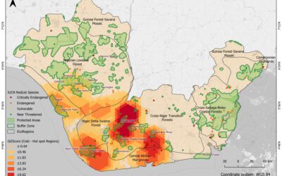
Christabel will present her M.Sc. thesis "ASSESSING THE ENVIRONMENTAL IMPACT OF OIL SPILLS IN THE NIGER DELTA, NIGERIA" on Monday 20th of December at 10am. From the abstract: "The Niger Delta region of Nigeria has been battling with an unprecedented number of oil...

M.Sc. idea presentation by Giovanni Matabishi
On Friday 26th of November at 10am Giovanni will present his M.Sc. idea on "Applying Artificial Light as a Focal Predictor to Model Bat Distribution in South Tyrol". His M.Sc. research is done in collaboration with EURAC research in Bolzano, South Tyrol, Italy. The...
MSc defense Diego Alarcon
Diego will present his M.Sc. thesis "Exploring the potential of remote sensing using machine learning to predict yields for table grape farms in Chile" on Friday, 10th of December at 9am. From the abstract: Table grape is among Chile most important crops, the country...

Internship and MSc idea presentation
On Friday 12th of November at 9am the following presentations will take place: Sofia Garcia:"Production of morphology data in African and Asian cities."Internship at DLR, supervisor: Henri Debray Annika Ludwig"Analysis of alpine grassland management dynamics based on...
MSc defense Malin Fischer
Malin Fischer will present her MSc thesis "Remote sensing and machine learning for irrigation mapping in complex landscapes: a case study in Mozambique" on Wednesday, 10th of November at 9 am. From her abstract: "Analyzing the spatio-temporal distribution of irrigated...
MSc idea, inno lab and internship
On Monday, 25th of October the following remote sensing presentation by our EAGLE students will take place: 9am MSc idea presentation by Nils Karges "Exploring spatial relationships of soundscape variables in urbanareas. " (supervisors: Hannes Taubenböck and Jürgen...
MSc thesis defense by Florian Baumgartner
Floran Baumgartner will present his M.Sc. thesis "The potential of Sentinel-2 time series for yield estimation of a perennial wild plant mix-ture using machine learning" on Friday 29th of October at 10am. From the abstract: "Monocultures are generally accompanied by...
MSc idea and InnoLab presentations
On Friday 15th of October at 10am we will have the following MSc idea and inno lab presentations: Nestor Gualsaqui - M.Sc. Thesis Idea: "Pre-crop emergence weed mapping using high satellite imagery"supervisor: Dr. Michael Thiel Yomna Eid - Innovation Lab:...
MSc defense by Frederic Schwarzenbacher
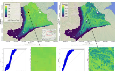
Frederic Schwarzenbacher will defend his M.Sc. thesis on Monday 6th at 3pm. The title is "Habitat suitability modeling for Desert Locust in the Awash River basin: Estimation of the breeding probability based on remote sensing, climatology and environment data" and...
MSc idea and internship presentations
Next Monday, Sept. 20th, at 9:30am the following EAGLE students will present thier MSc. thesis idea or internship: Sofia Garcia:“Estimating socioeconomic variables in Bolivia using satellite-based NTL and electricity consumption data”(Thesis idea, supervisors Hannes...