Aim
Aim of this course is to provide you with an overview on geographic processes of urbanization, the related demographic and structural changes of cities, and data analyses methods using remote sensing data for applications in urban geography.
Content
Humankind is within its largest migration ever: from rural areas into cities. The drivers of this global process of urbanization from demographic to economic and the related structural changes cities are facing will be discussed in this course. Remote sensing is one crucial data source in this dynamic transformation and its products are highly relevant for urban planning, as well as environmental management. Within this course different approaches and techniques are covered focusing on deriving relevant information about urbanized areas on different levels of detail. Uni-temporal-, multi-temporal-, and time series based image classification, segmentation, the analyses of point patterns, GIS analyses to assess spatial context and dependencies, as well as analyses in the 3D domain will be addressed in this course. This will be done providing and discussing example applications from different regions globally (e.g. urban sprawl analysis of megacities, the development of new dimensions of urban landscapes such as mega-regions, the rearrangement of business districts within the urban landscape, etc.). You will learn what capabilities Earth observation data, methods and products have for urban research and applications and how to design remote sensing based urban analysis, how to avoid caveats, troubleshoot errors and interpret the results.
General Course News and Updates
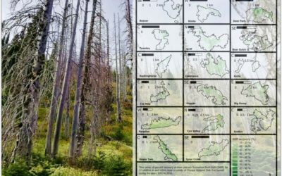
MSc defense by Martin Koenig
Martin König handed in his thesis with the title “Examining post-fire vegetation recovery with Landsat time series analysis in Olympic National Park (USA)”. Martin used remote sensing and ground collected data to make sense of vegetation recovery patterns for larger...
thesis idea presentations
On Monday 26th of July at 2pm we will have two MSc thesis idea presentations: Jakob Wachter (thesis idea):"Derivation of Snow cover in mountain regions from Webcam and Sentinel Imagery (thesis idea)" - supervisors Dr. Tobias Ullmann and Dr. Mattia Rossi, EURAC...
Thesis idea and internship presentation
On Thursday, July 22nd at 2pm we will have the following presentations: Haiyin Ye (thesis idea):"Monitoring gypsy moth outbreak using Sentinel-1 and Sentinel-2 data" - supervisors Soyeon bae and Martin Wegmann Christabel Ansah (internship):"Virtual...
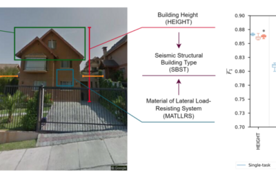
MSc Defense by Sandro Groth
Sandro Groth will present his M.Sc. thesis "Using street-level imagery and multi-task deep learning for multi-hazard risk related building characterization" on June 28th at 9am. From his abstract: "Accurate building characterization is a key component of multi-hazard...
MSc defense by Henrik Fisser
Henrik Fisser will present his M.Sc. thesis on Thursday 17th of June at 9am about “Sentinel-2-based moving truck detection for spatiotemporal road cargo emission and density approximation”. More details from his abstract: "In many countries freight is mainly...
MSc defense of Basil Tufail
Basil Tufail will present his M.Sc. thesis "Monitoring the Displacement of an Active Tailings Dam in Peru using Persistent Scatterer Interferometry (PS-InSAR)" on Friday, June 18th, at 9am. From the abstract: "As mining activities and the number of tailings dam grow...
MSc defense by Magdalena Halbgewachs
Magdalena Halbgewachs will present her MSc thesis "A Spectral Mixture Analysis and Landscape Metrics based framework for monitoring spatio-temporal forest cover changes: A case study in Mato Grosso, Brazil" on Wednesday 16th of June at 9am. From the abstract: More and...
Review of applications
Dear all applicants in 2021, we are currently working through the first evaluation of all 230 applications and will send out invitations for interviews in the next days/weeks. Unfortunately we are a bit delayed due to the high number of applications and we want to...
MSc thesis defense by Johannes Mast
Johannes Mast will present his thesis "Analyzing the relationship between urban morphology and economic subcenters with a focus on urban polycentricity using remote sensing and socioeconomic data" on Monday 14th of June at 9am. From the abstract: "Polycentricity...

high number of application submitted for 2021
The application deadline for the 2021 EAGLE generation passed yesterday and 230 application were submitted. That are 80 more than last year. Check out who started in the 2020 EAGLE generation here. We are now going through each single one and check for general...