Surface model creation from multi-source remote sensing data

Surface_model_creation

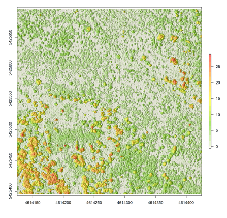
A canopy height model (CHM) overlaid on a hillshade product based on LiDAR point cloud

Nowadays there are plenty of 3D data sources which offer the possibility to model and monitor structural attributes of the landscape via the derivation of terrain, surface and canopy models. The core idea of this research project within an innovation laboratory is to leverage different sources of space- and airborne remote sensing data sources to derive digital surface models (DSMs) from forest stands. This can further provide the necessary database to compare their horizontal/vertical error as well as develop an error budget model by which the propagated error can be characterized. The remote sensing data sources which will be used here represent both landscape- and local scales, with airborne LiDAR and stereo SPOT data representing the landscape and unmanned aerial vehicle (UAV) data representing the local level. The methods include the state of the art as implemented in the available open-source software (FUSION, SAGA) as well as commercial photogrammetric suites (ERDAS Imagine).


read more news:

High alpine and snow training

High alpine and snow training

In collaboration with the German Alpine Club (DAV), Laura, one of our EAGLE students and Clara, a student assistant at our institute, recently participated in avalanche rescue training aimed at equipping individuals with essential skills and knowledge to respond...

semester wrap-up by our latest EAGLE generation

semester wrap-up by our latest EAGLE generation

Our latest generation of EAGLEs just wrote a nice blog post summarizing their first months within the EAGLE program, outlining how they bonded and formed a group plus how they experienced their first earth observation courses within our international M.Sc. program:...

International Day of Women and Girls in Science

International Day of Women and Girls in Science

We would like to celebrate the International Day of Women and Girls in Science with you! It is celebrated annually on February 11th. This day aims to promote full and equal access to science for women and girls, as well as to recognize the achievements of women in...

GRASS GIS introduced in our EAGLE MSc

GRASS GIS introduced in our EAGLE MSc

The very powerful and versatile spatial analysis program, GRASS, is introduced today within our EAGLE spatial data software course. GRASS provides a wide variety of functions, but just a few possibilities such as VI calculation, time-series or Python programming in...

Introduction to Whitebox software

Introduction to Whitebox software

The Whitebox geospatial software offers a wide range of functionality which are partly also not available in other packages, such as hydrological analysis or Lidar processing. Our earth observation EAGLE students are learning diverse geospatial software packages in...

Internship Networking event

Internship Networking event

Our EAGLEs have to conduct two internship and like to do them in quite diverse fields. Their research interests range from dry ecosystems to mountains, from conservation to agriculture, from the Arctic to Africa and from Earth Observation companies to large research...