M.Sc. thesis presentation by Karsten Wiertz

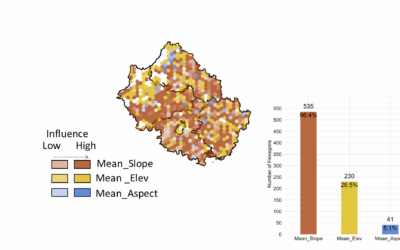
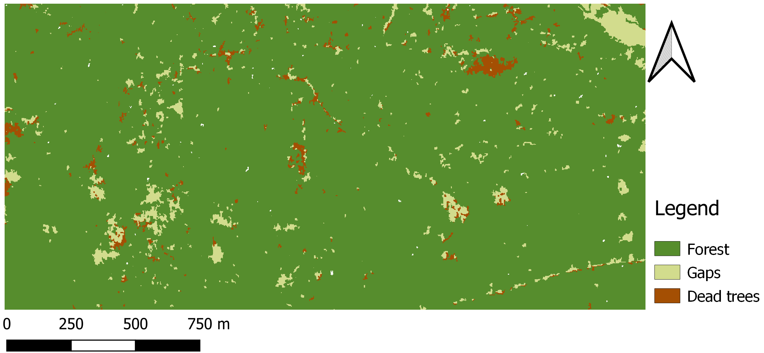
Karsten Wiertz will present his M.Sc. thesis on Wednesday 14th at 11am in room 0.004 KW 86 with the title “Development of a semi-automatic remote sensing approach for change- detection of forest structures in Bialowieza Forest.” From the abstract: The diversity of spatial structures in forests constitute an important factor for ecological processes and biodiversity. Therefore, the knowledge about the spatial distribution of forest structures is of high value for biodiversity studies. In recent years, object-based methods for the detection of forest parameters based on very high-resolution optical data have received increasing attention while seeing some methodological improvements. However, the challenge remains to define optimal parameters and produce objective and reproducible results. This study provides a way to extend the object-based method by comparing and selecting different segmentation results, attributes and classifiers. These options can be integrated into the GEOBIA framework and further extended by other options such as class structures and sample size.

read more news:

EAGLE summer dialogue

EAGLE summer dialogue

Our annual EAGLE summer dialogue was a great success again even though the weather was quite challenging. The EAGLEs organized a fantastic event with fun activities, great images reviving the last months and years and of course a BBQ, drinks and an outstanding...

new publication by our EAGLE student Clara Vydra

new publication by our EAGLE student Clara Vydra

Our EAGLE student Clara just published an article about snow cover variability in Central Asia - great to see our young EAGLE MSc students being on a good track for their scientific career. from the abstract: "Climate change is affecting the snow cover conditions on a...

UAS team – meme

UAS team – meme

The UAS (UAV or drone) team was quite busy the last months to collect data in Europe, Africa or Arctic and the group spend plenty of hours traveling and collecting Lidar, multispectral, thermal or hyperspectral data in various ecosystems. Of course in many cases faced...

scientific graphics course

scientific graphics course

Beside the various remote sensing courses such as radar, cloud computing, terrain analysis, urban analysis etc. we do also offer courses on softskills such as scientific writing, presentations as well scientific graphics and maps. Within our scientific graphics course...

EAGLE students introduce locust spatio-temporal modeling

EAGLE students introduce locust spatio-temporal modeling

Our EAGLE students Leonie, Sonja and Clara presented methods to model the spatial and temporal distribution of locust in France using statistical modelling approaches within R and the flexSDM package. The elaborated for two hours how the complex data preparation,...