Aim
In this seminar, we cover most aspects of remote sensing based assessment of Land Surface Dynamics. Topics such as snow cover dynamics, water body dynamics, forest cover and further vegetation dynamics, urbanization dynamics, coastal dynamics, or dynamics of geophysical parameters such as land surface temperature or selected indices will be addressed. In this contexts we look at opportunities arising from optical-, multi-spectral- and radar sensors, as well as thermal imagery. Data availability and access, as well as typical software tools for the handling of multispectral data or time-series analyses will be addressed as well. The course will consist of a theoretical part and a practical part, where the theory consists of a seminar (written seminar and presentation on a topic to be chosen from a list of available topics), and where the practical will consist of data processing examples.
Content
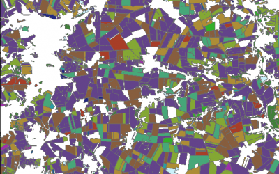
Topics cover most aspects of remote sensing based assessment of Land Surface Dynamics. Topics such as snow cover dynamics, water body dynamics, forest cover and further vegetation dynamics, urbanization dynamics, coastal dynamics, or dynamics of geophysical parameters such as land surface temperature or selected indices will be addressed. We adress questions such as climate change induced shifts of snow or rainy seasons, look at patterns of forest loss and degradation over time, analyze urbanization patterns and impacts of these processes on the natural environment, and assess changes in coastal morphology. Sensors in focus will be the ones allowing for long time series analyses, such as AVHRR, MODIS, ENVISAT, Landsat, TerraSAR-X, and the Sentinel Satellites.
Coding
Software
Techniques
Content
General Course News and Updates
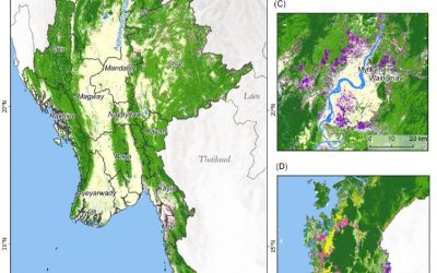
MSc on deforestation in Myanmar and its drivers
The MSc by Andrea Hess “Deforestation in Myanmar – what can we say about causes?” has been handed in. It has been supervised by Peter Leimgruber (Smithsonian Conservation Biology Institute) and Martin Wegmann. Deforestation in the tropics is a global issue. Tropical...
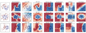
Deployment of a multi-classifier approach to improve land cover classification accuracy
This study will examine whether the application of hybrid classifiers increases the classification accuracy in comparison to a single classifier. A combination between parametric and non-parametric classifiers will be applied and their performance will be assessed....
Stereo photogrammetry for multi-temporal surface models based on aerial imagery
The data provided by aerial imagery are amongst the oldest sources of spatially explicit information for modern-time environmental management. These data are often captured over landscape-level domains using overlapping flight stripes to enable stereo photogrammetric...
Estimation of actual evapotranspiration in irrigation agricultural area of Uzbekistan using high resolution multi-frequent synthetic remote sensing data
Actual evapotranspiration (ETact) is an essential component of the water balance and its determination for large areas is difficult on regional scale and can be explored within an innovation laboratory. The use of remote sensing data to determine ETact is particularly...
Object based sequential masking classification using SAR and optical data
Remote sensing based crop mapping is still challenging when just relying on optical information as the only data source. Due to the unavailability of adequate optical satellite images the integration of SAR is promising and can be explored within an innovation...
Radiometric calibration, speckle reduction, geometric and terrain correction are essential preprocessing steps for SAR data. Within an innovation laboratory you will explore the different calibration and data preparation techniques for ground detected and single look...
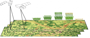
Surface model creation from multi-source remote sensing data
Nowadays there are plenty of 3D data sources which offer the possibility to model and monitor structural attributes of the landscape via the derivation of terrain, surface and canopy models. The core idea of this research project within an innovation laboratory is to...