Aim
In this module you will gain a detailed understanding of the advantages and challenges of Earth observation using Light Detection and Ranging (LiDAR) systems. Compared to other types of remote sensing data, the data from active Light Detection and Ranging (LiDAR) systems is of particular importance for local studies, where the 3D component (height) of objects is of relevance. Commonly LiDAR data is applied it in the field of digital terrain modelling, in forestry – e.g. for canopy height assessment, or urban structure applications. LiDAR embraces a range of active remote sensing systems mounted on different platforms, which provide valuable information for characterization of horizontal and vertical structure of the earth surface by measuring the travel time of laser pulses in visible and near-infrared spectral domains. The quality of scanning depends on the nature of the LIDAR system (discrete-return or full waveform) as well as on a set of other terrain- and data-driven factors. This course provides you with an overview on the theory and applications of LiDAR data, with a particular focus on airborne laser scanning. Following the initial theoretical sections on the principles and basic characteristics of LiDAR data, diverse practical steps and exercises will be implemented to provide real-world examples to illustrate how the LiDAR point clouds can be applied to extract information on terrain, surface and vegetation. These information will be further employed to model vegetation structural attributes on multiple spatial scales ranging from single trees to landscape levels.
Content
Block 1: Introduction to LiDAR (how does laser scanning work?)
- Reminder on general remote sensing issues: difference between active and passive sensing
- History of LiDAR measurements
- Basics of LiDAR data measurements (platforms, sensors)
- Airborne vs. spaceborne LiDAR: history, applications and data access
- Measurement of travel time of laser light (pulsed time of flight)
- On the concept of “structure”: why a third dimension is crucial?
Block 2: Principles of LiDAR measurements
- Platform navigation, orientation and positioning
- Difference between types of data acquisitions: discrete return and echo waveform
- The recorded parameters: elevation, height, signal intensity and co.
- The concept of „single-pulse“ vs. „multiple-pulse“
- How are the incoming returns recorded? first come- first served!
- Terrestrial LiDAR measurement: one position, rotating scanner
- Data formats and big data-management: each byte matters!
Block 3: Elevation models:
- General thoughts: why are the elevation models essential?
- Digital terrain models
- Digital surface models
- Normalized DSM (Canopy height models)
- Application fields: Forest, landscape and habitat representations
- Magnified focus on Forest (basic and derived parameters): Diameter at breast height, height, tree type proportions, tree type mapping, crown closure, stem count, growing stock und aboveground biomass
- Single tree measurements
- Urban: City models, roof top and building footprints
Block 4: Exercises in Open-Source domain of LiDAR data processing (Fusion/LDV, LASTools, R)
- Exercises on point cloud processing
- Import, export, visualizations and rendering
- Sample measurements, single tree measurements and associated tasks
- Elevation models
- Data trimming, cropping, smoothing and generalizing
- Catalog and descriptive communication
- Extraction of metrics for modeling purposes
- Thoughts on metrics
- Intensity: yes or no?
- Multi-scale metric extraction
- Multi-source metric extraction
- Class works and workshops (CIP-Pool/Homework)
- Literature review, discussion groups and public presentations
Coding
Coding examples and individual work will be covered
Software
Various software programs will be used, but mainly OpenSource software such as R.
Techniques
Different techniques will be introduced and practically applied.
Content
The content of scientific with regard to the audience will be discussed.
General Course News and Updates
MSc defense by Marius Witt
Marius Witt will present his M.Sc. thesis "Investigating discharge dynamics at catchment level usingremote sensing timeseries" on Friday 14th of January 2022 at 9am. From the abstract: The anthropogenic induced climate change is one of the foremost challenges of the...

Our students won the DLR Copernicus challenge 2021!
Great to see again our EAGLE students winning the DLR Copernicus challenge. Last year Henrik Fisser won with his truck detection approach, this year our EAGLE students Sofia Garcia, Annika Ludwig, Nils Karges, Andreas Bury and Antonio Castaneda won the DLR Copernicus...

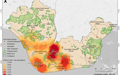
Great dashboard by our EAGLE students
our EAGLE students created various informative remote sensing and spatial environmental data dashboards and learned a lot how to communicate their Earth Observation research in an interactive online platform. One example by our student Ronald Okoth is shown below and...
MSc defense by Christabel Ansah
Christabel will present her M.Sc. thesis "ASSESSING THE ENVIRONMENTAL IMPACT OF OIL SPILLS IN THE NIGER DELTA, NIGERIA" on Monday 20th of December at 10am. From the abstract: "The Niger Delta region of Nigeria has been battling with an unprecedented number of oil...
M.Sc. idea presentation by Giovanni Matabishi
On Friday 26th of November at 10am Giovanni will present his M.Sc. idea on "Applying Artificial Light as a Focal Predictor to Model Bat Distribution in South Tyrol". His M.Sc. research is done in collaboration with EURAC research in Bolzano, South Tyrol, Italy. The...
MSc defense Diego Alarcon
Diego will present his M.Sc. thesis "Exploring the potential of remote sensing using machine learning to predict yields for table grape farms in Chile" on Friday, 10th of December at 9am. From the abstract: Table grape is among Chile most important crops, the country...

Internship and MSc idea presentation
On Friday 12th of November at 9am the following presentations will take place: Sofia Garcia:"Production of morphology data in African and Asian cities."Internship at DLR, supervisor: Henri Debray Annika Ludwig"Analysis of alpine grassland management dynamics based on...
MSc defense Malin Fischer
Malin Fischer will present her MSc thesis "Remote sensing and machine learning for irrigation mapping in complex landscapes: a case study in Mozambique" on Wednesday, 10th of November at 9 am. From her abstract: "Analyzing the spatio-temporal distribution of irrigated...
MSc idea, inno lab and internship
On Monday, 25th of October the following remote sensing presentation by our EAGLE students will take place: 9am MSc idea presentation by Nils Karges "Exploring spatial relationships of soundscape variables in urbanareas. " (supervisors: Hannes Taubenböck and Jürgen...
MSc thesis defense by Florian Baumgartner
Floran Baumgartner will present his M.Sc. thesis "The potential of Sentinel-2 time series for yield estimation of a perennial wild plant mix-ture using machine learning" on Friday 29th of October at 10am. From the abstract: "Monocultures are generally accompanied by...