Aim
In this module you will gain a detailed understanding of the advantages and challenges of Earth observation using Light Detection and Ranging (LiDAR) systems. Compared to other types of remote sensing data, the data from active Light Detection and Ranging (LiDAR) systems is of particular importance for local studies, where the 3D component (height) of objects is of relevance. Commonly LiDAR data is applied it in the field of digital terrain modelling, in forestry – e.g. for canopy height assessment, or urban structure applications. LiDAR embraces a range of active remote sensing systems mounted on different platforms, which provide valuable information for characterization of horizontal and vertical structure of the earth surface by measuring the travel time of laser pulses in visible and near-infrared spectral domains. The quality of scanning depends on the nature of the LIDAR system (discrete-return or full waveform) as well as on a set of other terrain- and data-driven factors. This course provides you with an overview on the theory and applications of LiDAR data, with a particular focus on airborne laser scanning. Following the initial theoretical sections on the principles and basic characteristics of LiDAR data, diverse practical steps and exercises will be implemented to provide real-world examples to illustrate how the LiDAR point clouds can be applied to extract information on terrain, surface and vegetation. These information will be further employed to model vegetation structural attributes on multiple spatial scales ranging from single trees to landscape levels.
Content
Block 1: Introduction to LiDAR (how does laser scanning work?)
- Reminder on general remote sensing issues: difference between active and passive sensing
- History of LiDAR measurements
- Basics of LiDAR data measurements (platforms, sensors)
- Airborne vs. spaceborne LiDAR: history, applications and data access
- Measurement of travel time of laser light (pulsed time of flight)
- On the concept of “structure”: why a third dimension is crucial?
Block 2: Principles of LiDAR measurements
- Platform navigation, orientation and positioning
- Difference between types of data acquisitions: discrete return and echo waveform
- The recorded parameters: elevation, height, signal intensity and co.
- The concept of „single-pulse“ vs. „multiple-pulse“
- How are the incoming returns recorded? first come- first served!
- Terrestrial LiDAR measurement: one position, rotating scanner
- Data formats and big data-management: each byte matters!
Block 3: Elevation models:
- General thoughts: why are the elevation models essential?
- Digital terrain models
- Digital surface models
- Normalized DSM (Canopy height models)
- Application fields: Forest, landscape and habitat representations
- Magnified focus on Forest (basic and derived parameters): Diameter at breast height, height, tree type proportions, tree type mapping, crown closure, stem count, growing stock und aboveground biomass
- Single tree measurements
- Urban: City models, roof top and building footprints
Block 4: Exercises in Open-Source domain of LiDAR data processing (Fusion/LDV, LASTools, R)
- Exercises on point cloud processing
- Import, export, visualizations and rendering
- Sample measurements, single tree measurements and associated tasks
- Elevation models
- Data trimming, cropping, smoothing and generalizing
- Catalog and descriptive communication
- Extraction of metrics for modeling purposes
- Thoughts on metrics
- Intensity: yes or no?
- Multi-scale metric extraction
- Multi-source metric extraction
- Class works and workshops (CIP-Pool/Homework)
- Literature review, discussion groups and public presentations
Coding
Coding examples and individual work will be covered
Software
Various software programs will be used, but mainly OpenSource software such as R.
Techniques
Different techniques will be introduced and practically applied.
Content
The content of scientific with regard to the audience will be discussed.
General Course News and Updates
EAGLE Internship Presentation “Earth Observation for Construction Statistics” at the Federal Agency for Cartography and Geodesy”
On January 28, 2025, Georg Starz will present her internship on "Earth Observation for Construction Statistics (BKG, Frankfurt)" at 12:15 in seminar room 3, John-Skilton-Str. 4a. From the abstract: The lack of affordable housing, especially in urban areas, is...
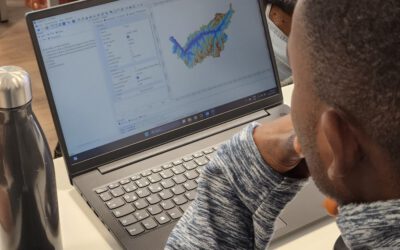
Empowering Students with SAGA GIS for Environmental Applications
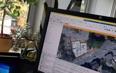
At EAGLE Earth Observation, we are committed to equipping our students with the tools and knowledge needed to excel in the field of environmental science. As part of this effort, our students are exploring the power of various scientific open-source software packages...
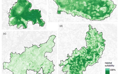
EAGLE Internship Presentation “Mapping Ecosystem Services in Norway”
On January 28, 2025, Sonja Maas will present her internship on " Mapping Ecosystem Services in Norway" at 13:00 in seminar room 3, John-Skilton-Str. 4a. From the abstract: Nature plays an important role in human well-being by providing essential services such as the...
Successful Master Thesis Defense by Konstantin Müller
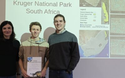
On January 14th, Konstantin Müller successfully defended his master’s thesis titled "Animal Path Segmentation and Analysis via Generalized Deep Neural Network Regression". Supervised by Jakob Schwalb-Willmann and Dr. Mirjana Bevanda, the presentation was delivered to...
EAGLE Internship Presentation “Glacier Surface Dynamics and Snowline Analysis Using Remote Sensing Data”
On January 21, 2025, Daria Ushakova will present her internship on "Glacier Surface Dynamics and Snowline Analysis Using Remote Sensing Data" at 13:00 in seminar room 3, John-Skilton-Str. 4a. From the abstract: This internship focused on analysing glacier surface...
EAGLE Master Thesis Defense “Linking Wildlife Conservation to Nature’s Contributions to People: A Case Study for the European Wildcat (Felis silvestris silvestris) in German Protected Forests”
On January 21, 2025, Svenja Dobelmann will defend her master thesis" Linking Wildlife Conservation to Nature’s Contributions to People: A Case Study for the European Wildcat (Felis silvestris silvestris) in German Protected Forests" at 12:00 in seminar room 3,...
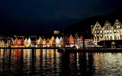
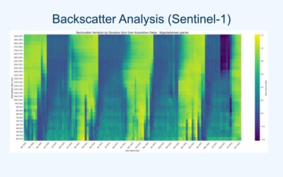
EAGLE Daria did her internship in Bergen
Our EAGLE student Daria recently wrapped up an internship at the University of Bergen in the Remote Sensing research group. With the support of her supervisor, Dr. Benjamin Abreu Robson, she got to work on the Jostedalsbreen glacier using drone and satellite data. Her...
EAGLE alumnus Henrik Fisser presenting polar research
Our EAGLE alumnus Henrik Fisser recently visited us after a research stay in the United States. He is now pursuing his PhD at UiT The Arctic University of Norway, specifically in the Earth Observation Department. UiT is renowned for its cutting-edge research in Earth...
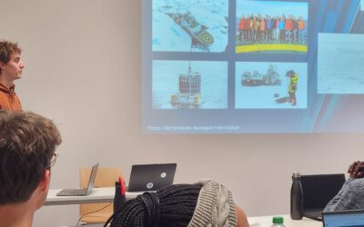
Orfeo Toolbox covered in our courses
As part of our international EAGLE MSc courses, we include comprehensive training on the powerful Orfeo Toolbox (OTB) software. OTB is an open-source library for processing remote sensing imagery, offering advanced algorithms for tasks such as image segmentation,...
EAGLE Internship Presentation ” Research and development of data strategies for disaster management, early warning systems, and refugee data analysis”
On January 07, 2025, Sarah Schneider will present her internship " Research and development of data strategies for disaster management, early warning systems, and refugee data analysis" at 14:00 in seminar room 3, John-Skilton-Str. 4a. From the abstract: The...