Aim
Spectroscopy and hyperspectral remote sensing enables to retrieve very detailed spectral information about a certain surface in dense bandwith intervalls. Information on the “spectral fingerprints” of surfaces is then available in a near-continuous manner. This allows for the differentiation of materials, such different geologic surfaces, different urban materials, or plants of different composition and vigor. Especially field- and laboratory spectroscopy has shown many benefits, as measurements can be carried out in a controlled environment, and can be directly visualized and explained. This course provides you insights into practical experiments using a field spectrometer, and subsequent data analysis to assess key environmental parameters such as plant health, soil moisture content, and geologic composition.
Content
The content of this course includes both the theoretical background of field and imaging spectroscopy, as well as practical experiments and subsequent data analysis. In particular, we will adress: the theoretical background of field and imaging spectroscopy / general reflectance and transmittance properties of plant leaves, canopies and soils / the quantification of biophysical and biochemical properties using spectroscopic measurements, feature parametrization and regression analysis / the advantages and challenges of existing and planned hyperspectral spaceborne sensors
Coding
Software
Techniques
Content
General Course News and Updates
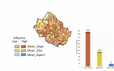
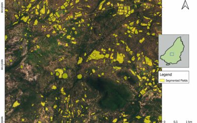
EAGLE Master Thesis Presentation “Ability of Random Forest Model to Predict the Mean and Standard Deviation of Winter Wheats Biomass in Bavaria: A case study”
On July 08, 2025, Sharmin Mim will defend her master thesis on "Ability of Random Forest Model to Predict the Mean and Standard Deviation of Winter Wheats Biomass in Bavaria: A case study " at 13:00 in seminar room 3, John-Skilton-Str. 4a. From the abstract:...
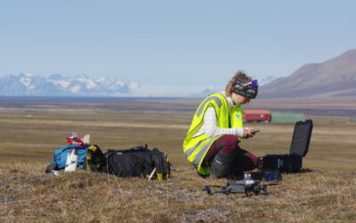
EAGLE Innolab Presentation “Ecology fieldwork in the high Arctic – A drone, tundra and reindeer”
On July 08, 2025, Ronja Seitz will present her Innolab on " Ecology fieldwork in the high Arctic - A drone, tundra and reindeer" at 12:00 in seminar room 3, John-Skilton-Str. 4a. From the abstract: Spitsbergen is the biggest island of the Svalbard archipelago,...
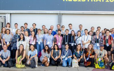
EORC Staff and EAGLE Students at ESA Living Planet Symposium 2025
This week, our EORC team and EAGLE MSc students are joining the global Earth observation community at the ESA Living Planet Symposium (LPS) 2025 — one of the most important gatherings for Earth system scientists, remote sensing experts, and space agencies worldwide....
EAGLE Master Defense: Quantification of Plant Functional Groups and Disturbances of Tundra Vegetation in the High Arctic Using High-Resolution UAV Timeseries Data
On July 01, 2025Ronja Seitz will present her Master Thesis on Quantification of Plant Functional Groups and Disturbances of Tundra Vegetation in the High Arctic Using High-Resolution UAV Timeseries Data " at 12:00 in seminar room 3, John-Skilton-Str. 4a. From...

Alpine Earth Observation: Learning Remote Sensing Where Science Meets Nature
Last week, our Alpine Earth Observation course brought a group of EAGLE students high into the Bavarian Alps, immersing them in a landscape where science and the raw beauty of high Alpine nature meet. Nestled at the Schneefernerhaus research station, the course...
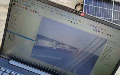
EAGLE Innolab: Development of a QGIS Plugin for the Planning of Ground-Mounted Photovoltaic Systems
On June 16, 2025, Georg Starz will present his Innolab results on " Development of a QGIS Plugin for the Planning of Ground-mounted Photovoltaic Systems " at 10:00 in seminar room 3, John-Skilton-Str. 4a. From the abstract: After a decline in the mid-2010s, the...
EAGLE Master Defense: Enhancing Land Cover Classification in Southern Africa Using Multi-Sensor and Multi-Algorithm Approaches
On June 10, 2025, Christobal Tobbin will present his Master Thesis on " Enhancing Land Cover Classification in Southern Africa Using Multi-Sensor and Multi-Algorithm Approaches" at 12:00 online. From the abstract: The Kavango-Zambezi (KAZA) region which is a part of...
Radio Bavaria BR2 covered our activities at the Africa-Festival
Once again, our team proudly took part in the International Africa Festival in Würzburg, continuing our active participation within the University of Würzburg's exhibition—a tradition we’ve upheld for many years. This year’s event highlighted the ongoing commitment of...

🎓 Congratulations to Sunniva McKeever on a Successful MSc Defense! 🌍🌲
Today, we proudly celebrate our MSc student Sunniva McKeever, who has just successfully defended her Master thesis entitled: “Spatio-temporal Forest Structure Dynamics in Germany: A Synthesis of Remote Sensing Products.” Supervised by Prof. Dr. Tobias Ullmann,...
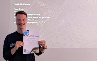
🚀 Hats Off to Janik Hoffmann for His Successful MSc Defense! 🛰📈
A big congratulations to Janik Hoffmann, who successfully defended his Master thesis today on the cutting-edge topic: “Deep Learning-driven SAR Image Super-Resolution.” Supervised by Prof. Dr. Tobias Ullmann and Dr. Wolfgang Koppe (Airbus Defence and Space GmbH),...