Aim
Within this course object-oriented image analysis is introduced using different very high to high remote sensing data. Different approaches and techniques will be covered to allow students to apply this method in applied science.
Content
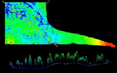
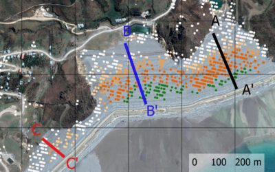
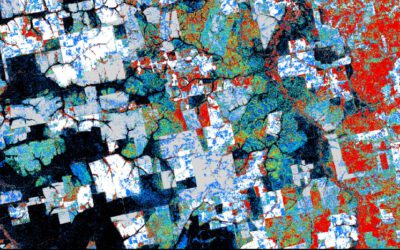
Theoretical basics of object-oriented methods are covered and discussed concerning their disadvantages and advantages for applied landscape analysis. Practical exercises are covering first segmentation steps to ready classified images. Various examples and technical settings are explored to outline the challenges and potential of object-oriented image analysis. Final outcome will be an individual project working on different set of images and methods.
Coding
Software
Techniques
Content
General Course News and Updates
MSc idea and internship presentations
Next Monday, Sept. 20th, at 9:30am the following EAGLE students will present thier MSc. thesis idea or internship: Sofia Garcia:“Estimating socioeconomic variables in Bolivia using satellite-based NTL and electricity consumption data”(Thesis idea, supervisors Hannes...
MSc defense by Belen Villacis
Belen will defend her M.Sc. thesis “Spatio-temporal patterns of urban expansion among main biomes in Ecuador using LULC data from 1990-2018” on Wednesday 8th of September, 2pm. From the abstract: "Over the past decades, the world has experienced an accelerated...
MSc defense by Ronja Lappe
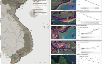
Ronja Lappe handed in her M.Sc. thesis "Assessing 30 years of coastline dynamics in Vietnam using the Landsat archive"from the abstract: "Almost half of the world’s human population lives in coastal regions, with 40 % less than ten meters above sea level. Due to...
MSc defense by Martin Koenig
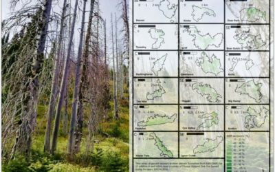
Martin König handed in his thesis with the title “Examining post-fire vegetation recovery with Landsat time series analysis in Olympic National Park (USA)”. Martin used remote sensing and ground collected data to make sense of vegetation recovery patterns for larger...
thesis idea presentations
On Monday 26th of July at 2pm we will have two MSc thesis idea presentations: Jakob Wachter (thesis idea):"Derivation of Snow cover in mountain regions from Webcam and Sentinel Imagery (thesis idea)" - supervisors Dr. Tobias Ullmann and Dr. Mattia Rossi, EURAC...
Thesis idea and internship presentation
On Thursday, July 22nd at 2pm we will have the following presentations: Haiyin Ye (thesis idea):"Monitoring gypsy moth outbreak using Sentinel-1 and Sentinel-2 data" - supervisors Soyeon bae and Martin Wegmann Christabel Ansah (internship):"Virtual...
MSc Defense by Sandro Groth
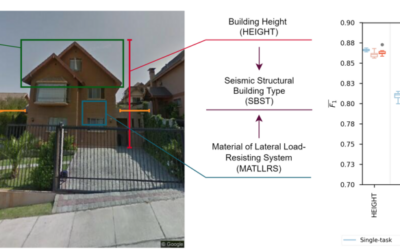
Sandro Groth will present his M.Sc. thesis "Using street-level imagery and multi-task deep learning for multi-hazard risk related building characterization" on June 28th at 9am. From his abstract: "Accurate building characterization is a key component of multi-hazard...
MSc defense by Henrik Fisser
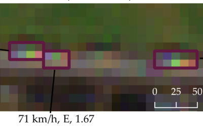
Henrik Fisser will present his M.Sc. thesis on Thursday 17th of June at 9am about “Sentinel-2-based moving truck detection for spatiotemporal road cargo emission and density approximation”. More details from his abstract: "In many countries freight is mainly...
MSc defense of Basil Tufail
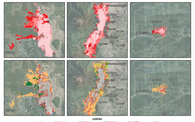
Basil Tufail will present his M.Sc. thesis "Monitoring the Displacement of an Active Tailings Dam in Peru using Persistent Scatterer Interferometry (PS-InSAR)" on Friday, June 18th, at 9am. From the abstract: "As mining activities and the number of tailings dam grow...
MSc defense by Magdalena Halbgewachs
Magdalena Halbgewachs will present her MSc thesis "A Spectral Mixture Analysis and Landscape Metrics based framework for monitoring spatio-temporal forest cover changes: A case study in Mato Grosso, Brazil" on Wednesday 16th of June at 9am. From the abstract: More and...