Aim
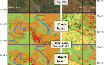
In this course we will learn the alternative image analysis paradigm of object-based image classification. Image objects are areas in images which consist of pixels from the same land-cover class (e.g. buildings, water surfaces, vegetation) and allow the application of additional image classification methods in comparison to pure pixel-based methods and the integration of multi-modal date (e.g. vector data).
Content
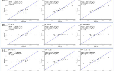
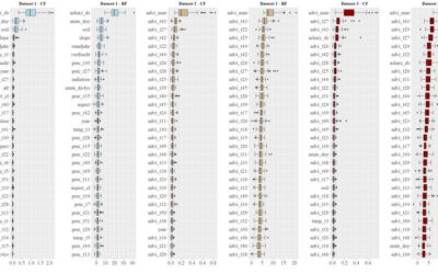
In the course we will use satellite images and high resolution aerial images in combination with vector data and analyze various image classification methods (nearest neighbor -> random forests -> deep learning) to extract relevant information from the images.
We will use the software “eCognition”.
The course will be held on 3 days in Würzburg plus an introductory lecture which is being held online.
Session 1: getting to know to image objects and eConition software, basic classification methods
Session 2: advanced classification (Machine Learning)
Session 3: Deep Learning
Coding
Software
Techniques
Content
General Course News and Updates
MSc defense Diego Alarcon
Diego will present his M.Sc. thesis "Exploring the potential of remote sensing using machine learning to predict yields for table grape farms in Chile" on Friday, 10th of December at 9am. From the abstract: Table grape is among Chile most important crops, the country...

Internship and MSc idea presentation
On Friday 12th of November at 9am the following presentations will take place: Sofia Garcia:"Production of morphology data in African and Asian cities."Internship at DLR, supervisor: Henri Debray Annika Ludwig"Analysis of alpine grassland management dynamics based on...
MSc defense Malin Fischer
Malin Fischer will present her MSc thesis "Remote sensing and machine learning for irrigation mapping in complex landscapes: a case study in Mozambique" on Wednesday, 10th of November at 9 am. From her abstract: "Analyzing the spatio-temporal distribution of irrigated...

MSc idea, inno lab and internship
On Monday, 25th of October the following remote sensing presentation by our EAGLE students will take place: 9am MSc idea presentation by Nils Karges "Exploring spatial relationships of soundscape variables in urbanareas. " (supervisors: Hannes Taubenböck and Jürgen...
MSc thesis defense by Florian Baumgartner
Floran Baumgartner will present his M.Sc. thesis "The potential of Sentinel-2 time series for yield estimation of a perennial wild plant mix-ture using machine learning" on Friday 29th of October at 10am. From the abstract: "Monocultures are generally accompanied by...
MSc idea and InnoLab presentations
On Friday 15th of October at 10am we will have the following MSc idea and inno lab presentations: Nestor Gualsaqui - M.Sc. Thesis Idea: "Pre-crop emergence weed mapping using high satellite imagery"supervisor: Dr. Michael Thiel Yomna Eid - Innovation Lab:...
MSc defense by Frederic Schwarzenbacher
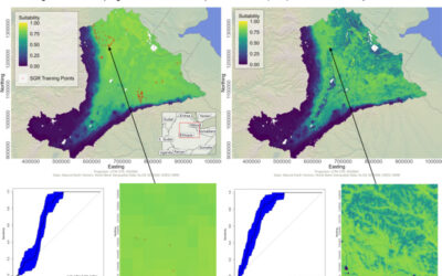
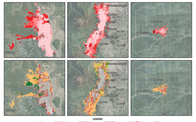
Frederic Schwarzenbacher will defend his M.Sc. thesis on Monday 6th at 3pm. The title is "Habitat suitability modeling for Desert Locust in the Awash River basin: Estimation of the breeding probability based on remote sensing, climatology and environment data" and...
MSc idea and internship presentations
Next Monday, Sept. 20th, at 9:30am the following EAGLE students will present thier MSc. thesis idea or internship: Sofia Garcia:“Estimating socioeconomic variables in Bolivia using satellite-based NTL and electricity consumption data”(Thesis idea, supervisors Hannes...
MSc defense by Belen Villacis
Belen will defend her M.Sc. thesis “Spatio-temporal patterns of urban expansion among main biomes in Ecuador using LULC data from 1990-2018” on Wednesday 8th of September, 2pm. From the abstract: "Over the past decades, the world has experienced an accelerated...
MSc defense by Ronja Lappe
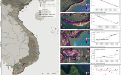
Ronja Lappe handed in her M.Sc. thesis "Assessing 30 years of coastline dynamics in Vietnam using the Landsat archive"from the abstract: "Almost half of the world’s human population lives in coastal regions, with 40 % less than ten meters above sea level. Due to...