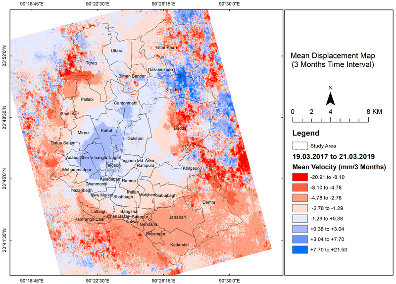
Johni Miah will present his M.Sc. thesis ” Detecting and Assessing Ground Subsidence of Dhaka City, Bangladesh, Using Synthetic Aperture Radar Data of Sentinel-1” on September 30th at 2pm in OKW 86. From the abstract: ” The identification and measurement of ground deformations in urban areas are essential to detect the vulnerable regions of the cities, which are susceptible to hazard. Interferometric Synthetic Aperture Radar (InSAR) is an effective and cost efficient technique for monitoring land subsidence due to its large spatial coverage and high accuracy. In this study, we investigated wide area surface subsidence characteristics in Dhaka city using Sentinel-1A Terrain Observation with Progressive Scans (TOPS) Synthetic Aperture Radar (SAR) images acquired from 19 March 2017 to 23 March 2019. In this paper, Small Baseline Subset (SBAS) InSAR approach, which generates interferograms between two SAR images with small spatial baseline and can reduce both spatial and temporal decorrelation for the long-term deformation. This paper analyses the spatial pattern of ground displacement of the Dhaka city and identifies the vulnerable areas in terms of subsidence. The research also shows the links between ground deformation and geological structure with land filling activities in the city. It is found that the transition of the subsidence is different depending on the location. The subsidence rate is high in urban fringes of north, south, northeast and south east. From the SBAS-InSAR analysis, the LOS displacement velocities for 2 years are varying from -151 to +108 mm/ 2 years. The mean displacement for 1 year is fluctuating from -79 to +72 mm/ year. For half a year (6 months interval), the mean displacement velocity ranges from -34 to +47 mm/ 6 months. The mean displacement for 3 months interval differs from -21 to +22 mm/3 months. The biggest subsidence found in the urban fringes of Dhaka city such as Uttar Khan, Badda, fringe part of Turag and Demra. From the distribution of the deformations, the uplift tends to occur on the core city areas. One of the major causes of subsidence is the geological structure of the city. The large subsidence has occurred in the Alluvium and the artificial fills areas. This study shows that the SBAS InSAR can be a useful tool for long-term continuous subsidence monitoring. Based on current results, it is worth to keep monitoring this region with current workflow.”







![[spotlight] Lecturer Spotlight: Martin Wegmann](https://eagle-science.org/wp-content/uploads/2026/07/Martin_Wegmann_EAGLE_lecture_2026-400x250.jpg)