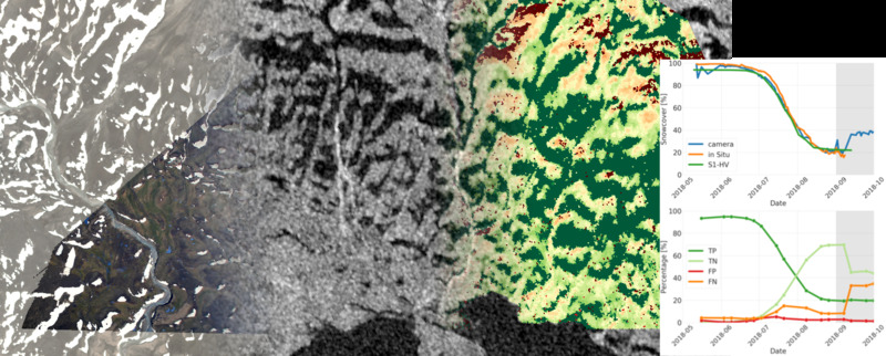
Sebastian Buchelt will present his M.Sc. thesis “Analysis of High-Resolution Spatio-Temporal Patterns of Snowmelt using Orthorectified Photo Cameras, Sentinel-1 Time Series and Digital Elevation Data” in a virtual course room. From the abstract: ” Snow is one of the most dynamic features in our Earth system. It influences the global energy, water and carbon cycle. Especially in the Arctic, snowmelt is a key regulator for photosynthetic activity and is strongly influenced by amplified global warming. Snow meltout and snow cover (SC) are essential variables to better understand ongoing changes. This study evaluates the potential of Sentinel-1 (S1) synthetic aperture radar (SAR) time series for monitoring snow cover with high spatio-temporal resolution to cover its understudied large small-scale heterogenity. We use 97 same-orbit dual-polarized SAR images acquired in Interferometric Wide swath mode (IW) of the years 2017 and 2018 to identify the meltout of snow during summer using backscatter intensity thresholds derived from the SAR time series. SC maps are then derived from meltout. Both products are validated against orthorectified in-situ time-lapse camera images, wherefore an improved procedure was developed within this study. The analysis based on HV polarization outperformed the HH polarization. With HV, over 50% of meltout pixels could be correctly detected within a period of one S1 repeat cycle. The SC Fraction could be reproduced with an R² value of more than 0.95. The overall accuracy of SC maps was always above 75% and in more than half of the cases above 90%. Hence, S1 time series data enables automated SC monitoring at very high spatio-temporal scale (20m, 6 days) over large regions with good accuracy and should therefore be pursued further on.”







![[spotlight] Lecturer Spotlight: Martin Wegmann](https://eagle-science.org/wp-content/uploads/2026/07/Martin_Wegmann_EAGLE_lecture_2026-400x250.jpg)