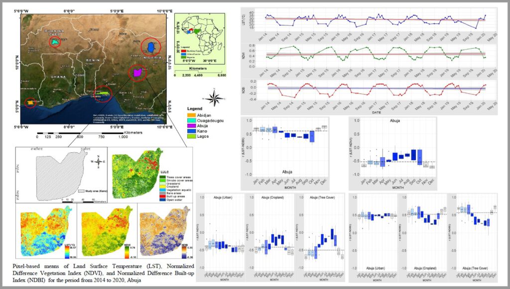
Navid Chamani is defending his thesis “Investigation on the intra-annual variations of the relationship between Landsat 8-derived LST and spectral indices in west Africa” on September 25th 10am.
from the abstract: “Monitoring the variations of the land surface temperature (LST) as a critical parameter in land surface processes and climate/environmental changes is vital for comprehensive land management. LST is in a constant interplay with land surface dynamics and responds significantly to the land cover changes. In recent decades, remote sensing has emerged as a robust tool in the rapid measurement of these changes and their mutual relationship. In this study, the intra-annual relationship between LST and two spectral indices (SIs): Normalized Difference Vegetation Index (NDVI) and Normalized Difference Built-up Index (NDBI), derived from Landsat 8 satellite imageries from 2014 to 2020, was investigated in five different areas in West Africa; Kano, Abuja, Lagos, Ouagadougou, and Abidjan using google earth engine (GEE). As well as the impact of different land use land cover (LULC) classes on both LST variations and the LST-SIs correlation was evaluated. For this purpose, three land cover types: built-up areas, cropland, and tree cover areas were selected from S2 PROTOTYPE LAND COVER 20M MAP OF AFRICA 2016 product. The results showed that LST is negatively correlated with NDVI and positively associated with NDBI. But, the mean of r values was spatiotemporally variable. The LST-SIs relationship showed higher association values during the dry season. In arid and semi-arid regions like Kano and Ouagadougou, the LST-NDVI correlation was not significant (r < -0.5). However, the LST-NDBI association showed r values above 0.50 during some dry months. The well-vegetated areas like Lagos and Abidjan had the highest LST-SIs association throughout the year. Tree cover areas experienced lower LST values compared with the city areas and cropland. In addition, the results indicated that the intra-annual relationship between LST and SIs within different LULC types developed differently. In Kano, Abuja, and Ouagadougou, the tree cover areas demonstrated the highest LST-SIs association, while in Lagos and Abidjan, the smallest association was recorded in tree cover areas. Our results indicate the importance of two parameters, including time and space, to understand the relationship between the land surface components and LST. These findings can be applied for better formulation of land-use strategies to exploit land resources and also to avoid the adverse ecological/economic consequences of seasonal climatic changes.” supervised by Michael Thiel
![[spotlight] Lecturer Spotlight: Martin Wegmann](https://eagle-science.org/wp-content/uploads/2026/07/Martin_Wegmann_EAGLE_lecture_2026-400x250.jpg)


