On July 24, 2026, Wajiha Yasmeen will present her inno lab results on ” Comparing intra-urban thermal patterns using high-resolution HotSat-1 and Landsat 8 data from 14 U.S. cities ” at 12:00 at the EORC meeting room/1st floor in John-Skilton-Str. 4a
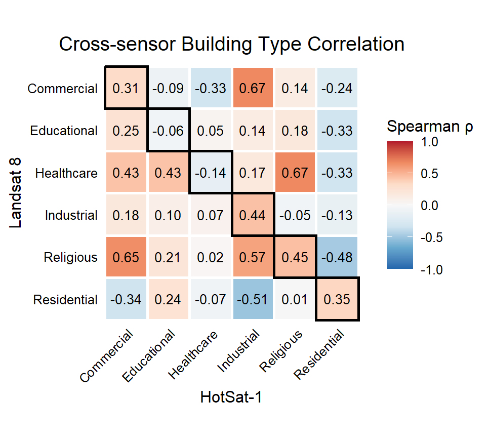
From the abstract: Higher resolution thermal imagery is widely expected to improve the study of surface urban heat island effect, but this has rarely been tested directly against established sensors like Landsat. Therefore, we compared the relative thermal behavior of building and street types across 14 U.S. cities using sensor-specific normalized thermal indicators. Radiance from high resolution thermal satellite HotSat-1 and LST values from Landsat-8 were extracted for individual urban features using OpenStreetMap building and road polygons, and Getis-Ord Gi* hot and cold spot analysis was computed over both rasters to identify statistically significant thermal clusters. Because the two sensors record physically different quantities, values were converted to within-scene percentile ranks, and median ranks per building and road class were compared across sensors. Cross-sensor agreement was then evaluated using Spearman rank correlation and assessed in relation to each city’s Köppen-Geiger climate classification. The results indicate that agreement between the two sensors varies considerably between cities, reflecting urban heterogeneity where Landsat’s coarser pixels mix more surface types, weakening correspondence with the higher-resolution imagery.
1st supervisor: Dr. Martin Wegmann
From the abstract: Higher resolution thermal imagery is widely expected to improve the study of surface urban heat island effect, but this has rarely been tested directly against established sensors like Landsat. Therefore, we compared the relative thermal behavior of building and street types across 14 U.S. cities using sensor-specific normalized thermal indicators. Radiance from high resolution thermal satellite HotSat-1 and LST values from Landsat-8 were extracted for individual urban features using OpenStreetMap building and road polygons, and Getis-Ord Gi* hot and cold spot analysis was computed over both rasters to identify statistically significant thermal clusters. Because the two sensors record physically different quantities, values were converted to within-scene percentile ranks, and median ranks per building and road class were compared across sensors. Cross-sensor agreement was then evaluated using Spearman rank correlation and assessed in relation to each city’s Köppen-Geiger climate classification. The results indicate that agreement between the two sensors varies considerably between cities, reflecting urban heterogeneity where Landsat’s coarser pixels mix more surface types, weakening correspondence with the higher-resolution imagery.
1st supervisor: Dr. Martin Wegmann






![[spotlight] Lecturer Spotlight: Martin Wegmann](https://eagle-science.org/wp-content/uploads/2026/07/Martin_Wegmann_EAGLE_lecture_2026-400x250.jpg)