About
Michael studied Geography at the University of Graz, Austria (2000-2007) with a focus on remote sensing, geoinformatics and human geography. He joined DLR in 2008 for his PhD thesis on the integration of remotely sensed spatial information in urban urban for the integration in empirical social scientific analysis in cooperation with the German Institute for Economic Research (DIW). Between 2013-2022 he was a PostDoc at DLR focusing on studies in the context of urban poverty research, urban green and air pollution. Since 2022 he leads the City and Society Research group at DLR. Michael is passionate about the inspiring work and always curios about finding new insights about our urban environments.

Recent News

EAGLE Innolab Presentation “Earth observation data cube for the Volcanoes National Park, Rwanda”
On July 15, 2025, Jean de Dieu Tuyizere will present his Innolab on " Earth observation data cube for the Volcanoes National Park, Rwanda" at 12:00 in seminar room 3, John-Skilton-Str. 4a. From the abstract: The increasing availability of Earth observation (EO)...

WG: EAGLE Innolab Presentation “Automated Basement Identification in SVI: A Two-Stage Learning Framework”
On July 15, 2025, Gökce Budak will present her Innolab results on " Automated Basement Identification in SVI: A Two-Stage Learning Framework" at 13:00 in seminar room 3, John-Skilton-Str. 4a. From the abstract: The presence of a basement, a structural attribute not...
EAGLE Master Thesis Presentation “Ability of Random Forest Model to Predict the Mean and Standard Deviation of Winter Wheats Biomass in Bavaria: A case study”
On July 08, 2025, Sharmin Mim will defend her master thesis on "Ability of Random Forest Model to Predict the Mean and Standard Deviation of Winter Wheats Biomass in Bavaria: A case study " at 13:00 in seminar room 3, John-Skilton-Str. 4a. From the abstract:...
EAGLE Innolab Presentation “Ecology fieldwork in the high Arctic – A drone, tundra and reindeer”
On July 08, 2025, Ronja Seitz will present her Innolab on " Ecology fieldwork in the high Arctic - A drone, tundra and reindeer" at 12:00 in seminar room 3, John-Skilton-Str. 4a. From the abstract: Spitsbergen is the biggest island of the Svalbard archipelago,...
EAGLE Master Defense: Quantification of Plant Functional Groups and Disturbances of Tundra Vegetation in the High Arctic Using High-Resolution UAV Timeseries Data
On July 01, 2025Ronja Seitz will present her Master Thesis on Quantification of Plant Functional Groups and Disturbances of Tundra Vegetation in the High Arctic Using High-Resolution UAV Timeseries Data " at 12:00 in seminar room 3, John-Skilton-Str. 4a. From...

EAGLE Innolab: Development of a QGIS Plugin for the Planning of Ground-Mounted Photovoltaic Systems
On June 16, 2025, Georg Starz will present his Innolab results on " Development of a QGIS Plugin for the Planning of Ground-mounted Photovoltaic Systems " at 10:00 in seminar room 3, John-Skilton-Str. 4a. From the abstract: After a decline in the mid-2010s, the...
EAGLE Master Defense: Enhancing Land Cover Classification in Southern Africa Using Multi-Sensor and Multi-Algorithm Approaches
On June 10, 2025, Christobal Tobbin will present his Master Thesis on " Enhancing Land Cover Classification in Southern Africa Using Multi-Sensor and Multi-Algorithm Approaches" at 12:00 online. From the abstract: The Kavango-Zambezi (KAZA) region which is a part of...
EAGLE Master Defense: Deep Learning-driven SAR Image Super-Resolution
On May 20, 2025, Janik Hoffmann will present his Master thesis on Deep Learning-driven SAR Image Super-Resolution" at 13:00 in seminar room 3, John-Skilton-Str. 4a. From the abstract: Synthetic Aperture Radar (SAR) is a microwave remote sensing system that is used for...
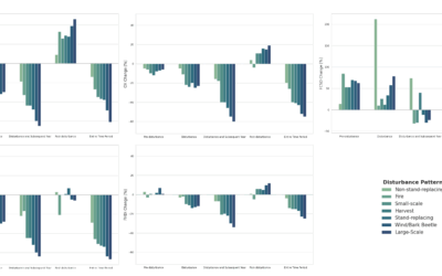
EAGLE Master Defense: Spatio-temporal Forest Structure Dynamics in Germany: A Synthesis of Remote Sensing Products
On May 20, 2025, Sunniva McKeever will present her Master thesis on " Spatio-temporal Forest Structure Dynamics in Germany: A Synthesis of Remote Sensing Products" at 12:00 in seminar room 3, John-Skilton-Str. 4a. From the abstract: Germany’s forests have experienced...
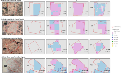
EAGLE Master Theses defense “Revealing Inconsistencies in Population Datasets in Refugee and IDP Camps”
On April 03, 2025, Lallu Nikerthil Prathapan will present her Master Thesis " Revealing Inconsistencies in Population Datasets in Refugee and IDP Camps " at 15:00 in seminar room 3, John-Skilton-Str. 4a. From the abstract: Accurate population estimates are crucial for...