Ahmed Saadallah will defend his M.Sc. thesis “The Potential of Earth Observation for Monitoring Agricultural Lands in Egypt (1984-2017)” on Wednesday 10th of April at 2pm in the student working room JMW 52.
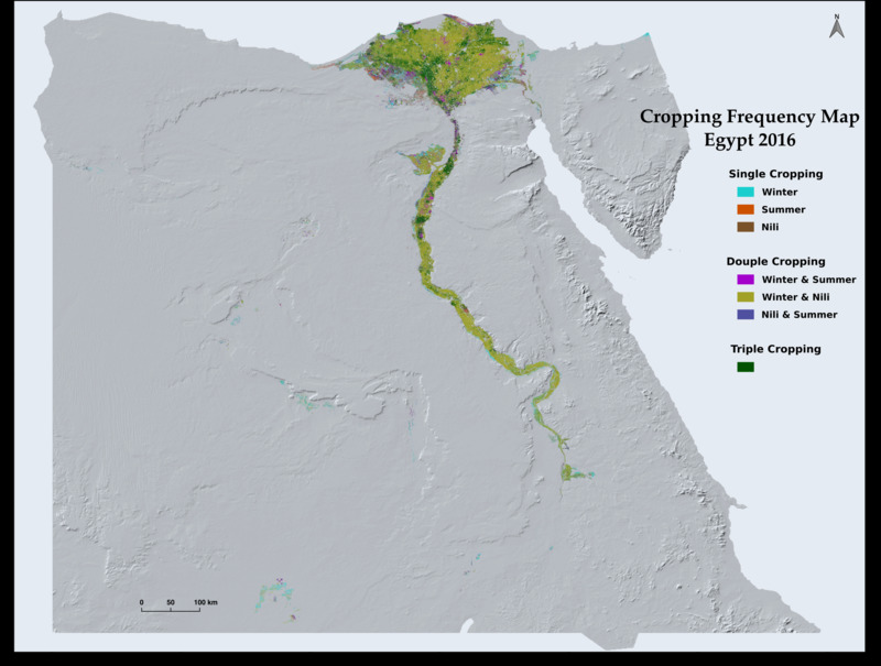
The need for accurate and timely information on the extent and the use-intensity of agricultural lands is growing with the increasing pressure on agricultural systems to increase production, in order to narrow the food gap, while maintaining at the same time the sustainability of the agricultural resources and reducing the negative impacts on the environment. In Egypt, such information is urgently needed for generating effective policies and improving management practices in order to promote the agricultural sector to address current and future challenges. Over the past four decades, it has been proven through the use of Earth Observation (EO) applications that remote sensing data can provide this information accurately, quickly, and at low cost. In this study, the extent and the use-intensity of the agricultural land in Egypt were mapped on an annual basis from 1984 to 2017 using Landsat time series data. Pixel-based supervised classification approach, using Random Forest algorithm, was used to map the extent of cultivated land area annually. Harmonic analysis was used for smoothing and filling the gaps in the time series data of Landsat derived Normalized Difference Vegetation Index (NDVI) in order to identify the Peak of Season (POS) phenological parameter, which was used later to map cropping frequency and estimate Multiple Cropping Intensity (MCI) on annual basis. The overall average classification accuracy was 89%. In addition, the results indicate that the cultivated area in Egypt expanded from 25760 km2 in 1984 to 32539 km2 in 2017, with an overall average increase of 185 km2 per year. Moreover, 86% of the total cultivated area in Egypt on average was multi-cropped. The overall average MCI at the national level for the last 34 years since 1984 is 214%.

