
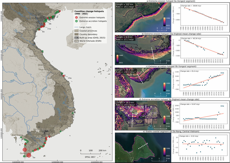
Ronja Lappe handed in her M.Sc. thesis “Assessing 30 years of coastline dynamics in Vietnam using the Landsat archive”
from the abstract: “Almost half of the world’s human population lives in coastal regions, with 40 % less than ten meters above sea level. Due to population and economic growth in many coastal areas, any negative physical impact on these ecosystems has socio-economic consequences. Globally, Vietnam is among the countries most exposed to coastal hazards. The densely populated 3,260-km long coastline shows a high diversity of coastal landscapes. Satellite archives, such as Landsat, provide a free and powerful opportunity for long-term area-wide monitoring of the coastal zone. An automatic analysis of coastline dynamics from 1984 to 2021 was conducted in this thesis for Vietnam’s entire coastal region. The analysis is based on Landsat-derived annual 75th percentile Modified Normalized DifferenceWater Index (MNDWI) composites, representing the mean high-water level. Sub-pixel contours are extracted for quantifying coastline change rates along shore-normal transects using linear regressions. A hotspot analysis identifies the coastal segments with the most severe erosion and accretion. The automatic Landsat-based coastline detection yielded a sub-pixel accuracy of 8 m, validated on a single Landsat acquisition. Almost half of Vietnam’s coastline did not experience any significant change, while one quarter has been classified as erosional and one as accretional, respectively. Highest accretion rates with change rates of up to +47 m/year are mainly associated with the construction of artificial coastlines, while highest erosion rates of -28 m/year may be related to both natural sediment redistribution processes and human activity. Most erosion and accretion hotspots are concentrated in the large river deltas of the Mekong in the south and the Red River in the north. Both regions are characterized by rapid economic and population growth. The presented coastline detection approach has additionally been tested in northern Alaska and Sylt (Wadden sea), showing promising results for a potential global transferability of the method.”
supervisors: Dr. rer. nat. Tobias Ullmann (Titel hat sich vielleicht geändert?) (Uni Würzburg) und Dr. Felix Bachofer (DLR)
![[spotlight] Lecturer Spotlight: Thilo Erbertseder](https://eagle-science.org/wp-content/uploads/2026/10/Thilo_Lecturer_Portrait_EAGLE_EORC_2026-400x250.jpg)




![[Spotlight] Lecturer Spotlight: Julian Faeth](https://eagle-science.org/wp-content/uploads/2026/10/Julian_Faeth_EORC_EAGLE_2026-400x250.jpg)


