Aim:
Within this course different methods to analyse point pattern statistically and conduct a spatial prediction are covered. Students will learn how to design such analysis, how to avoid caveats, troubleshoot errors and interpret the results.
Content
Different statistical methods will be applied for analysing spatial point patterns, such as vegetation samples or biodiversity related information. These results will be statistically predicted using methods such as GLM, GAM, Random Forest or MaxEnt. Implications of spatial point patterns as well as chosen environmental parameters will be discussed. All methods will be practically applied during the course using the programming language R. The needed pre-requisites are covered in the course “Applied Programming for Remote Sensing and GIS“.
Coding
Software
Techniques
Content
General Course News and Updates

EAGLE workshop on Earth Observation application
Our first EAGLE workshop on Earth Observation applications covered various topics. After a heartily welcome by Tobias Ullmann did more than 50 participants listen to the following talks: Ása Aðalsteinsdóttir: “SAR Monitoring in Iceland” Katrin Wernicke:...

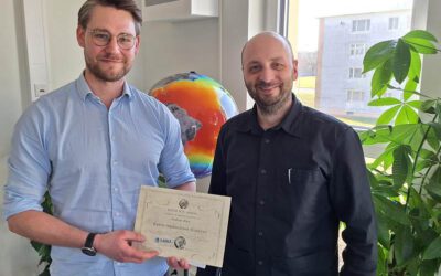
DGPF award for our EAGLE MSc Luisa Wagner
We are very happy to congratulate our former EAGLE student Luisa Wagner for the 2nd prize of the Karl‐Kraus‐Nachwuchsförderpreis 2024. Luisa received this award for her M.Sc. thesis which she handed in early last year on "Analysis of ice shelf front dynamics in Pine...

Master Thesis Defense: “Modelling the Spatio-Temporal Suitability of Urban Environments for Aedes Aegypti Mosquitoes based on their Bio-Ecological Characteristics in Rio de Janeiro “
On Friday, March 22, at 12:00 Rutendo Mukaratirwa will present her master thesis on " Modelling the Spatio-Temporal Suitability of Urban Environments for Aedes Aegypti Mosquitoes based on their Bio-Ecological Characteristics in Rio de Janeiro " in seminar room 3,...
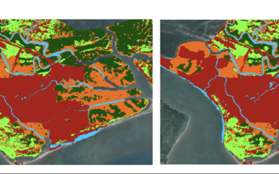
Master Thesis Defense: “Development of Caribbean Seagrass Ecosystem Accounts fusing Earth Observation with Biophysical Modeling of Coastal Carbon” on Tuesday, March 19, 2024
On Tuesday, March 18, at 15:00 Andrea Cárdenas Reyes will present her master thesis on "Development of Caribbean Seagrass Ecosystem Accounts fusing Earth Observation with Biophysical Modeling of Coastal Carbon" in seminar room 3, John-Skilton-Str. 4a. ...
Andreas Bury successfully defended his MSc thesis
Andreas Bury successfully defended his MSc thesis "Assessing Air Pollution in Urban Environments: A Comprehensive Analysis Using Earth Observation and In Situ Measurements" at the EAGLE colloquium on the 8th of March 2024. His research offers an approach to...
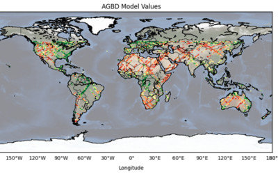
Master Thesis Defense: “CNN-based Global Aboveground Biomass Estimation using Sentinel-2 and GEDI” on Tuesday, March 12, 2024
On Tuesday, March 12, at 12:00 Ka Hei Chow will present her master thesis on " CNN-based Global Aboveground Biomass Estimation using Sentinel-2 and GEDI" in seminar room 3, John-Skilton-Str. 4a. Abstract: Accurate global estimation of aboveground biomass...
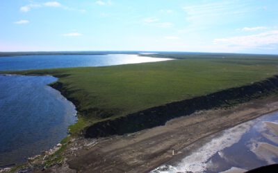
Master Thesis Defense: “Assessing the Mangrove Ecosystem in Eastern Obolo, Niger Delta” on Monday, March 18 at 11:30
On Monday, March 18, at 11:30 Hyeonmin Kang will present her master thesis on "Assessing the Mangrove Ecosystem in Eastern Obolo, Niger Delta" in seminar room 3, John-Skilton-Str. 4a. From the abstract: This study focuses on assessing the mangrove ecosystem in Eastern...

Master Thesis Defense: “Assessing Air Pollution in Urban Environments: A Comprehensive Analysis Using Earth Observation and In Situ Measurements” on Friday, March 08 at 13:00
On Friday, March 08, at 13:00, Andreas Bury will present his master thesis on "Assessing Air Pollution in Urban Environments: A Comprehensive Analysis Using Earth Observation and In Situ Measurements" in seminar room 3, John-Skilton-Str. 4a. From the...

High alpine and snow training
In collaboration with the German Alpine Club (DAV), Laura, one of our EAGLE students and Clara, a student assistant at our institute, recently participated in avalanche rescue training aimed at equipping individuals with essential skills and knowledge to respond...

semester wrap-up by our latest EAGLE generation
Our latest generation of EAGLEs just wrote a nice blog post summarizing their first months within the EAGLE program, outlining how they bonded and formed a group plus how they experienced their first earth observation courses within our international M.Sc. program:...